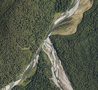
The Harper River is a tributary of the Wilberforce River which itself flows into the Rakaia River in New Zealand's Canterbury region. It is located in the Southern Alps and a pass in the Harper River headwaters leads into the Waimakariri River catchment. One of the most popular tramping routes in Canterbury enters the East Harper via Cass Saddle and exits via Lagoon Saddle at the head of the West Harper.
The waters of the Harper River and its major tributary, the Avoca River, are channelled into Lake Coleridge via a structure known as the Harper Diversion which was constructed in 1921 as part of a hydroelectricity project.
The Harper Avoca catchment has been the site of much ecological research since the mid-1950s.
It is well serviced by huts on Lagoon and Cass Saddles, the West Harper, Hamilton Hut at the junction of the two branches of the Harper, Avoca Hut in the headwaters of the Avoca, two huts at Back Basins Creek, a small two man hut up Back Basins Creek and a larger hut that can be rented off Glenthorne Station near the junction of the Avoca and Harper Rivers. The Harper is comparatively well documented by early European explorers including Julius von Haast and Samuel Butler.
The Potomac River is a major river in the Mid-Atlantic region of the United States that flows from the Potomac Highlands in West Virginia to the Chesapeake Bay in Maryland. It is 405 miles (652 km) long, with a drainage area of 14,700 square miles (38,000 km2), and is the fourth-largest river along the East Coast of the United States and the 21st-largest in the United States. More than 5 million people live within its watershed.
The Murrumbidgee River is a major tributary of the Murray River within the Murray–Darling basin and the second longest river in Australia. It flows through the Australian state of New South Wales and the Australian Capital Territory, descending 1,500 metres (4,900 ft) over 1,485 kilometres (923 mi), generally in a west-northwesterly direction from the foot of Peppercorn Hill in the Fiery Range of the Snowy Mountains towards its confluence with the Murray River near Boundary Bend.
The Avoca River, an inland intermittent river of the north–central catchment, part of the Murray-Darling basin, is located in the lower Riverina bioregion and Central Highlands and Wimmera regions of the Australian state of Victoria. The headwaters of the Avoca River rise on the northern slopes of the Pyrenees Range and descend to flow into the ephemeral Kerang Lakes.
The Namoi River, a major perennial river that is part of the Barwon catchment of the Murray–Darling basin, is located in the Northern Tablelands and North West Slopes districts of New South Wales, Australia.
The Clyde River is an open intermediate tide-dominated drowned valley estuary or perennial river that flows into the Tasman Sea at Batemans Bay, located in the South Coast region of New South Wales, Australia.
The Liao River is the principal river in southern Northeast China, and one of the seven main river systems in China. Its name is derived from the Liao region, a historical name for southern Manchuria, from which the Liaoning province, Liaodong Peninsula, and Liao dynasty also derive their names. The river is also popularly known as the "mother river" in Northeast China. Coursing 1,345 kilometres (836 mi) long, the Liao River system drains a catchment basin of over 232,000 square kilometres (90,000 sq mi), but its mean discharge is quite small at only about 500 cubic metres per second (18,000 cu ft/s), about one-twentieth that of the Pearl River. The Liao River has an exceedingly high sediment load because many parts of it flow through powdery loess.
The Loddon River, an inland river of the north–central catchment, part of the Murray-Darling basin, is located in the lower Riverina bioregion and Central Highlands and Loddon Mallee regions of the Australian state of Victoria. The headwaters of the Loddon River rise on the northern slopes of the Great Dividing Range east of Daylesford and descend to flow north into the Little Murray River, near Swan Hill. The river is impounded by the Cairn Curran and Laanecoorie reservoirs.
The Kiwalik River is a stream on the Seward Peninsula in the U.S. state of Alaska. The headwaters of the river originate in the eastern portion of the peninsula, around Granite Mountain. The river flows north to its mouth at Kiwalik Lagoon, Chukchi Sea. The start of the 20th century mining town of Candle is found on its western bank at the confluence of Candle Creek. The ore minerals and materials found in the river basin are galena, gold, pyrite, scheelite, silver and sphalerite, and the primary commodities are tungsten, lead and zinc.
The Wilberforce River is a river in the Southern Alps of New Zealand. It is located in western Canterbury and is naturally a tributary of the Rakaia River, but like the Harper River, it has had some of its flow diverted into Lake Coleridge as part of a hydroelectricity project. This diversion boosted the output of the Coleridge Power Station and was established in 1977.
Crooked River is a river that flows from headwaters in the Southern Alps to Lake Brunner in the West Coast region of New Zealand's South Island. It is named for the erratic path it takes. Near Lake Brunner, it passes through reasonably flat farmland, but closer to its source, it rushes through gorges and rapids. One tributary is the Poerua River from Lake Poerua.
The Dandenong Creek is an urban creek of the Port Phillip catchment, located in the eastern and south-eastern Greater Melbourne region of the Australian east coast state of Victoria. The creek descends approximately 550 metres (1,800 ft) over its course of 53 kilometres (33 mi) before joining the Eumemmerring Creek to form the Patterson River and eventually draining into the Beaumaris Bay.
Nesquehoning Creek is an east flowing 14.9-mile-long (24.0 km) tributary of the Lehigh River in northeastern Pennsylvania in the United States.
The Waihao River is a natural watercourse in the Canterbury region of New Zealand's South Island. It flows into the Wainono Lagoon near Studholme.
Waimate Creek is a natural watercourse in the southern Canterbury region of New Zealand's South Island. Its original Māori name was Te Waimatemate, which means "slowly moving waters".
Craigieburn Forest Park is a protected area in the South Island of New Zealand, adjacent to Arthur's Pass National Park to the north.
The Doubtful River is a river in the Canterbury region of New Zealand. It rises near Mount Barron and flows south then south-east through Lake Sumner Forest Park, reaching the Boyle River 40 kilometres (25 mi) west of Hanmer Springs. The Doubtful Range lies to the south. The Doubtless River and Devilskin Stream are tributaries entering from the north.
The Trent River is a river of the West Coast Region of New Zealand's South Island. It flows east from its source in the Kaimata Range northeast of Otira, turning north to reach the valley of the Ahaura River via the Tūtaekurī River.
The Robinson River is a river in the West Coast Region of the South Island of New Zealand. It is a tributary of the Upper Grey River and much of the river lies within the Lake Sumner Conservation Park. Rising on the slopes of Mount Boscawen on the main divide about 12 kilometres (7.5 mi) south of the Lewis Pass, the river runs west-southwest along a straight, narrow valley before turning northwest to reach the Upper Grey.
The Alice River is a river located on the Cape York Peninsula of Far North Queensland, Australia.
The Wangapeka Track is a tramping track in the north-west of the South Island of New Zealand. It is one of the main tramping tracks in the Kahurangi National Park, a protected area managed by the Department of Conservation. The route traverses the southern end of the park, from the historic Wangapeka goldfields area west of Tapawera, to the coastal plains of the West Coast at Little Wanganui. The route is 59 km (37 mi) long, and crosses the Wangapeka and Little Wanganui saddles, each over 1,000 m (3,300 ft) in elevation. The track passes through the valleys of the Wangapeka River, Karamea River, Taipō River and Little Wanganui River. The majority of the track is in river valleys and under forest cover, with small sections in tussock land at Stag Flat and the Little Wanganui Saddle. It typically takes walkers 4–6 days to complete the route.
This page is based on this Wikipedia article Text is available under the CC BY-SA 4.0 license; additional terms may apply. Images, videos and audio are available under their respective licenses.