
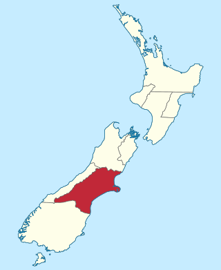
Canterbury is a region of New Zealand, located in the central-eastern South Island. The region covers an area of 44,503.88 square kilometres (17,183.04 sq mi), making it the largest region in the country by area. It is home to a population of 666,300.
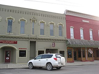
Avoca is a town in Steuben County, New York, United States. The population was 1,996 at the 2020 census.

Christchurch is the largest city in the South Island and the second-largest city by urban area population in New Zealand, after Auckland. Christchurch lies in the Canterbury Region, near the centre of the east coast of the South Island, east of the Canterbury Plains. It is located near the southern end of Pegasus Bay, and is bounded to the east by the Pacific Ocean and to the south by Banks Peninsula. The Avon River / Ōtākaro flows through the centre of the city, with a large urban park along its banks. Christchurch has a reputation for being an 'English' city, with its architectural identity and common nickname the "Garden City" due to similarities with garden cities in England.

The Avoca River, an inland intermittent river of the north–central catchment, part of the Murray-Darling basin, is located in the lower Riverina bioregion and Central Highlands and Wimmera regions of the Australian state of Victoria. The headwaters of the Avoca River rise on the northern slopes of the Pyrenees Range and descend to flow into the ephemeral Kerang Lakes.

The Waimakariri River is one of the largest rivers in Canterbury, on the eastern coast of New Zealand's South Island. It flows for 151 kilometres (94 mi) in a generally southeastward direction from the Southern Alps across the Canterbury Plains to the Pacific Ocean.

The Rakaia River is in the Canterbury Plains in New Zealand's South Island. The Rakaia River is one of the largest braided rivers in New Zealand. The Rakaia River has a mean flow of 203 cubic metres per second (7,200 cu ft/s) and a mean annual seven-day low flow of 87 m3/s (3,100 cu ft/s). In the 1850s, European settlers named it the Cholmondeley River, but this name lapsed into disuse. The name Rakaia comes from Māori "Ō Rakaia", meaning the place where people were arranged by ranks.

The Avoca is a river in County Wicklow, Ireland. It is contained completely within the county. Its length is 35 miles (56.3 km).

Avoca is a small town near Arklow, in County Wicklow, Ireland. It is situated on the River Avoca.

Avoca is a town in the Central Highlands of Victoria, Australia, 71 kilometres (44 mi) north west of Ballarat. It is one of two main towns in the Pyrenees Shire, the other being Beaufort to the south.

William John Alexander Montgomery was a New Zealand politician and merchant from Little River on Banks Peninsula. Born in London, he lived in a number of places and pursued a number of occupations before settling in Christchurch, New Zealand.
The Canterbury Province was a province of New Zealand from 1853 until the abolition of provincial government in 1876. Its capital was Christchurch.

Cass is a small locality in inland Canterbury on New Zealand's South Island, near Arthur's Pass. It is known for its small railway station which was the subject of the 1936 painting Cass by Rita Angus, voted in 2006 New Zealand's favourite work of art. It is also the location of a University of Canterbury field station established in 1914. Cass currently has a single permanent resident.

The Harper River is a tributary of the Wilberforce River which itself flows into the Rakaia River in New Zealand's Canterbury region. It is located in the Southern Alps and a pass in the Harper River headwaters leads into the Waimakariri River catchment. One of the most popular tramping routes in Canterbury enters the East Harper via Cass Saddle and exits via Lagoon Saddle at the head of the West Harper.

Environment Canterbury, frequently abbreviated to ECan, is the promotional name for the Canterbury Regional Council. It is the regional council for Canterbury, the largest region in the South Island of New Zealand. It is part of New Zealand's structure of local government.
Avoca is a locality in the Canterbury region of New Zealand. It is situated along the Midland Railway Line between Craigieburn and Staircase. There are no permanent residents, but it once supported a small number of railway staff.

Avoca was an electoral district of the Legislative Assembly in the Australian state of Victoria from 1859 to 1889. It was based in northern Victoria. It was defined by the 1858 Electoral Act as:
Commencing at the source of the River Avoca in the Main Dividing Range ; thence northwards by that river and by a line bearing north to the River Murray ; thence by the River Murray to the River Loddon; thence south-wards by the River Loddon to McNeil's Creek;[a] thence by McNeil's Creek to the Main Dividing Range; and thence westerly by the Main Dividing Range to the commencing point aforesaid, including the parish of Tarnagulla.
Colin James Callan was an Australian-born New Zealand swimmer who specialised in butterfly and breaststroke, and represented New Zealand at the 1950 British Empire Games. He won eight New Zealand national swimming titles.

