New Zealand State Highway 25

Last updated

State Highway 25 NZ.svg

State Highway 25
Route information
Maintained by NZ Transport Agency
Length 231 km (144 mi)
Major junctions
West end SH 2 State Highway 2 NZ.svg near Mangatarata
East end SH 2 State Highway 2 NZ.svg at Waihi
Location
Primary
destinations
Thames, Coromandel, Whitianga, Tairua, Pauanui, Whangamata
Highway system
State Highway 24 NZ.svg SH 24 SH 26 State Highway 26 NZ.svg

State Highway 25 (SH 25) is a North Island state highway in New Zealand that loops around the Coromandel Peninsula. It is a major route for holidaymakers and tourists which has access to some of New Zealand's most idyllic beach holiday spots. The summer period around Christmas and New Year's Eve is a particularly busy period for the highway. The road is very scenic, but also windy in many parts as well as single carriage on the entire route, and is prone to accidents. It is New Zealand's third longest two-digit state highway, after SH 35 and SH 94. It is part of the Pacific Coast Highway.

North Island The northern of the two main islands of New Zealand

The North Island, also officially named Te Ika-a-Māui, is one of the two main islands of New Zealand, separated from the larger but much less populous South Island by Cook Strait. The island's area is 113,729 square kilometres (43,911 sq mi), making it the world's 14th-largest island. It has a population of 3,749,200.

The New Zealand state highway network is the major national highway network in New Zealand. Nearly 100 roads in the North and South Islands are state highways. All state highways are administered by the NZ Transport Agency.

Coromandel Peninsula peninsula in New Zealand

The Coromandel Peninsula on the North Island of New Zealand extends 85 kilometres north from the western end of the Bay of Plenty, forming a natural barrier to protect the Hauraki Gulf and the Firth of Thames in the west from the Pacific Ocean to the east. It is 40 kilometres wide at its broadest point. Almost the entire population lies on the narrow coastal strips fronting the Hauraki Gulf and the Bay of Plenty. In clear weather the peninsula is clearly visible from Auckland, the country's biggest city, which lies on the far shore of the Hauraki Gulf, 55 kilometres to the west. The peninsula is part of the local government areas of Thames-Coromandel District and the Waikato Region and is part of the Regional Tourism Organisation representing The Coromandel.

Contents

There is one spur road, SH 25A, that crosses the peninsula west to east, almost intersecting SH 25 at both ends.

Route

SH 25 begins at SH 2 3 km north of Mangatarata at a recently constructed roundabout. [1] The highway travels eastwards across the Hauraki Plains where it crosses the Waihou River on the new Kopu Bridge, it hits the junction with SH 26 and moves northwards through the township of Thames. The road continues north, skirting the Firth of Thames into the small township of Coromandel before travelling eastwards across the peninsula to the Bay of Plenty side towards Whitianga. SH 25 veers south-west on the Whitianga Bypass, through Coroglen and Whenuakite and over windy hill roads into Tairua, where travellers can access Pauanui. SH 25 then continues southwards, past the intersection of the spur road 25A and towards Whangamata. The road bypasses Whangamata on the west side and continues southbound until it reaches its final terminus in Waihi at the intersection of Kenny Street & Rosemont Road. [2]

New Zealand State Highway 2 road in New Zealand

State Highway 2 runs north–south through eastern parts of the North Island of New Zealand from the outskirts of Auckland to Wellington. It runs via Tauranga in the Bay of Plenty, Gisborne, and Napier and Hastings in Hawke's Bay. It is the second-longest highway in the North Island, after State Highway 1, which runs the length of both of the country's main islands.

Hauraki Plains

The Hauraki Plains are a geographical feature and non-administrative area located in the northern North Island of New Zealand, at the lower (northern) end of the Thames Valley. They are located 75 kilometres south-east of Auckland, at the foot of the Coromandel Peninsula and occupy the southern portion of a rift valley bounded on the north-west by the Hunua Ranges, to the east by the Coromandel and Kaimai Ranges and the west by a series of undulating hills which separate the plains from the much larger plains of the Waikato River. Broadly, the northern and southern parts of the Hauraki Plains are administered by the Hauraki District and the Matamata-Piako District respectively.

Waihou River river in New Zealand

The Waihou River is located in the northern North Island of New Zealand. Its former name, Thames River, was bestowed by Captain James Cook in November 1769, when he explored 14 mi (23 km) of the river from the mouth. An older Māori name was "Wai Kahou Rounga". A 1947 Geographic Board enquiry ruled that the official name would be Waihou.

Spurs

State Highway 25a NZ.svg

State Highway 25A
Location Kopu–Hikuai
Length 28.2 km (17.5 mi)

State Highway 25A (SH 25A) traverses the Coromandel Peninsula from west to east directly. This 28.2 km road begins at the intersection of SH 26 only 400m away from the SH 25/SH 26 intersection. It terminates on SH 25 between Tairua and Whangamata. [3]

New Zealand State Highway 26 road in New Zealand

State Highway 26 (SH 26) is a state highway in the North Island of New Zealand, linking Hamilton with the Coromandel Peninsula. It starts in the Hamilton suburb of Hillcrest, and travels 96 kilometres to Kopu, 6 kilometres south of Thames. It passes through Morrinsville, Te Aroha and Paeroa.

Tairua Place in Waikato, New Zealand

The town of Tairua is on the east coast of the Coromandel Peninsula in the North Island of New Zealand. It lies at the mouth of the Tairua River on its north bank and on the small Paku Peninsula. The population was 1,227 in the 2013 Census, a decrease of 42 from 2006. Tairua is a Māori name which translates literally as tai: tides, rua: two.

Whangamata Place in Waikato, New Zealand

The town of Whangamata is sited on the southeast coast of the Coromandel Peninsula in the North Island of New Zealand. It is located 30 kilometres north of Waihi, to the north of the western extremity of the Bay of Plenty.

Route changes

SH 25 once went through the town centres of Whitianga and Whangamata. In Whitianga, the bypass was constructed carrying traffic away from the original route via Buffalo Beach Road, Albert Street, and South Highway. [4] In Whangamata, SH 25 bypasses the town via Tairua Road instead of using Harry Watt Drive, Hetherington Road and Port Road.

Whitianga Place in Waikato, New Zealand

Whitianga is a town on the Coromandel Peninsula, in the Waikato Region of New Zealand's North Island. The town is located on Mercury Bay, on the northeastern coast of the peninsula. The town has a permanent population of 5,080 as of June 2018, making it the second-largest town on the Coromandel Peninsula behind Thames.

In the early 2000s the last sections of the highway were sealed, particularly around the northern end of the Coromandel Peninsula between Coromandel township and Whitianga. [5]

In 2011 NZTA completed the new Kopu Bridge, a two lane structure, across the Waihou River. It replaced the previous one-lane bridge, where at times holidaymakers had to queue for hours to cross. The old bridge, which was built in 1928, is scheduled to be deconstructed although a key part of its history will still be preserved. [6] [7]

Kopu Bridge bridge in New Zealand

The (old) Kopu Bridge is a single-lane swing bridge that spans the Waihou River, near its emergence into the Firth of Thames in the Thames-Coromandel District of New Zealand's North Island. The bridge was completed in 1928 and was part of State Highway 25. The swinging span in the middle of the bridge is 43 metres long and with an overall length of 463 metres, the bridge was the longest and oldest single lane bridge within the state highway network. It is also New Zealand's only remaining operational swing bridge.

See also

Related Research Articles

Paeroa Minor urban area in Waikato, New Zealand

Paeroa is a small town in New Zealand, in the northern Waikato region of the Thames Valley. Located at the foot of the Coromandel Peninsula, it is close to the junction of the Waihou and Ohinemuri Rivers, 20 kilometres from the coast at the Firth of Thames. The population is 3900.

Thames-Coromandel District Territorial authority in Waikato, New Zealand

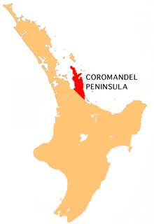
The Thames-Coromandel District is a territorial authority district in the North Island of New Zealand, covering all the Coromandel Peninsula and extending south to Hikutaia.

Hikuai Place in Waikato, New Zealand

Hikuai is a small community on the Tairua River towards the base of the Coromandel Peninsula in the North Island of New Zealand. It lies 40 kilometres north of Waihi and 10 kilometres southwest of Tairua, close to the junction of State Highways 25 and 25A, the latter of which is a winding road cutting across the steep Coromandel Range of hills. It is a tourist hot spot in days such as New Zealand Labour Weekend, The Christmas Holidays and especially when Tairua and Pauanui are busy.

New Zealand State Highway 1 road in New Zealand

State Highway 1 is the longest and most significant road in the New Zealand road network, running the length of both main islands. It appears on road maps as SH 1 and on road signs as a white number 1 on a red shield, but it has the official designations SH 1N in the North Island, SH 1S in the South Island.

New Zealand State Highway 20 road in New Zealand

State Highway 20, also known as the Southwestern Motorway, is a New Zealand state highway linking State Highway 1 at Manukau City Centre with State Highway 16 in Point Chevalier, via Mangere and Onehunga. Along with its spurs, State Highway 20A and 20B, the state highway serves Auckland Airport, the country's largest, therefore making State Highway 20 a key arterial route connecting the airport to the wider Auckland region and most of the upper North Island. The route also forms the southern part of the Western Ring Route, a 48 kilometres (30 mi) motorway route bypassing central Auckland. It is the only New Zealand State Highway that is entirely motorway.

New Zealand State Highway 5 road in New Zealand

State Highway 5 is the second shortest of New Zealand's eight national highways. It extends from SH 1 at Tirau, on the plains of the Waikato River, to SH 2, close to the Hawke Bay coast at Bay View, 10 km north of Napier. Distances are measured from north to south.

New Zealand State Highway 3 road in New Zealand

State Highway 3 (SH 3) is one of New Zealand's eight national state highways. It serves the west coast of the country's North Island and forms a link between State Highway 1 and State Highway 2. Distances are measured from north to south.

Coroglen Place in Waikato, New Zealand

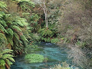
Coroglen is a locality in the Coromandel Peninsula, New Zealand. It lies on State Highway 25, 18 kilometres south of Whitianga and 26 kilometres north west of Tairua. The "Tapu-Coroglen Road", a windy gravel road, connects it across the Coromandel Range with Tapu on the west coast of the peninsula.

New Zealand State Highway 30 road in New Zealand

State Highway 30 (SH 30) is a New Zealand state highway, linking the Waikato and Bay of Plenty towns of Te Kuiti, Mangakino, Rotorua, and Whakatane.

New Zealand State Highway 38 road in New Zealand

State Highway 38 is a road in the North Island of New Zealand that starts from SH 5 near Waiotapu, and ends at Wairoa, where it connects to SH 2. It is the shortest connection from the central North Island (Rotorua) to the East Coast (Gisborne), but it is not often used as such. Large parts of the road are narrow and winding, and about 74 kilometres (46 mi) is unsealed. Travel on this highway takes roughly four hours.

New Zealand State Highway 57 road in New Zealand

State Highway 57 is a New Zealand state highway, linking State Highway 1 north of Ohau to State Highway 3 east of Ashhurst, via Levin, Shannon, Massey University and the southern suburbs of Palmerston North. The highway connects State Highway 1 traffic coming north from Wellington to the city of Palmerston North, and further to the Manawatu Gorge, allowing passage to the eastern side of the North Island and to the twin cities of Napier and Hastings. The highway is classified by the NZTA as a national strategic road.

State Highway 17 was the designation for a 32-kilometre stretch of highway in northern Auckland in the North Island of New Zealand from December 1999 to October 2012. It is now designated Urban Route 31 and consists of the Hibiscus Coast Highway, Dairy Flat Highway and Albany Expressway. It linked State Highway 1 at Puhoi in the north with SH 1 at Albany in the south. Its main destinations were the towns of Waiwera, Orewa, Red Beach, Whangaparaoa, Silverdale, Dairy Flat and the suburb of Albany. Prior to its inception as SH 17, the road was part of SH 1, and was redesignated as SH 17 as the Northern Motorway was extended northwards and took over the designation of SH 1.

State Highway 46 (SH 46) is a New Zealand state highway in the central North Island.

State Highway 27 (SH 27) is a state highway in the Waikato Region of the North Island of New Zealand. It is an important north/south link along the Waihou/Piako valley and forms an important transport route across the mostly dairy farming Matamata-Piako District. SH 27, in conjunction with SH 2, is often used as an alternative route to SH 1 between Auckland and Tauranga, Rotorua and Taupo.

References

  1. "SH2/25 Intersection Improvement". New Zealand Transport Agency. Retrieved 3 March 2016.
  2. State Highway 25 on Google Maps
  3. State Highway 25A on Google Maps
  4. "Revoking a Section of State Highway and Declaring a Section of State Highway-State Highway 25, Thames-Coromandel District". NZ Gazette. 6 September 2012. Retrieved 5 July 2016.
  5. "Regions on the road to safer driving". New Zealand Herald. 30 June 2000.
  6. "Kopu Bridge replacement". New Zealand Transport Agency. Retrieved 3 March 2016.
  7. "The future of old Kopu Bridge". New Zealand Transport Agency. 11 July 2013.