
Coromandel, also called Coromandel Town to distinguish it from the wider district, is a town on the Coromandel Harbour, on the western side of the Coromandel Peninsula, which is in the North Island of New Zealand. It is 75 kilometres east of the city of Auckland, although the road between them, which winds around the Firth of Thames and Hauraki Gulf coasts, is 190 km long. The population was 1,870 as of June 2024.

The Thames-Coromandel District is a territorial authority district in the North Island of New Zealand, covering all the Coromandel Peninsula and extending south to Hikutaia.

Hauraki District is a territorial authority governed by the Hauraki District Council within the Waikato region of New Zealand. The seat of the council is at Paeroa.
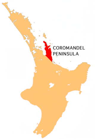
The Coromandel Peninsula on the North Island of New Zealand extends 85 kilometres (53 mi) north from the western end of the Bay of Plenty, forming a natural barrier protecting the Hauraki Gulf and the Firth of Thames in the west from the Pacific Ocean to the east. It is 40 kilometres (25 mi) wide at its broadest point. Almost its entire population lives on the narrow coastal strips fronting the Hauraki Gulf and the Bay of Plenty. In clear weather the peninsula is clearly visible from Auckland, the country's biggest city, which lies on the far shore of the Hauraki Gulf, 55 kilometres (34 mi) to the west. The peninsula is part of the Thames-Coromandel District and the Waikato Region.
Hikuai is a small community on the Tairua River near the base of the Coromandel Peninsula in the North Island of New Zealand. It lies 40 kilometres north of Waihi and 10 kilometres southwest of Tairua, close to the junction of State Highways 25 and 25A, the latter of which is a winding road cutting across the steep Coromandel Range of hills. It is a tourist hot spot at times such as New Zealand Labour Day weekend, the Christmas and New Year holiday, and especially when Tairua and Pauanui are busy.

Colville, a small town in the north of the Coromandel Peninsula in the North Island of New Zealand, lies 26 kilometres north of Coromandel in Colville Bay on the Hauraki Gulf, and is the northernmost town of any note on the peninsula. North of Colville, 28 kilometres of rough road lead to the small settlement of Port Jackson, close to the peninsula's northwesternmost point, Cape Colville and 20 km to Port Charles on the northeastern side.

Tairua is a beachside town located on the east coast of the Coromandel Peninsula in the North Island of New Zealand in the Thames-Coromandel District. It is located 150 kilometres east of Auckland and 125 kilometers north of Tauranga. It lies at the mouth of the Tairua River on its north bank and on the small Paku Peninsula. As the 2023 census, the town had a permanent population of 1,630. Tairua is a Māori name which translates literally as tai: tides, rua: two.

Ngatea is a small town on the Hauraki Plains in the North Island of New Zealand. It is located 18 kilometres southwest of Thames and 70 kilometres southeast of Auckland. Ngatea lies on the Piako River, eight kilometres south of its outflow into the Firth of Thames.

The town of Whangamatā is on the southeast coast of the Coromandel Peninsula in the North Island of New Zealand. It is located 30 kilometres north of Waihi, to the north of the western extremity of the Bay of Plenty.

Matauri Bay is a bay in New Zealand, situated 30 km north of Kerikeri, in Whangaroa county, just north of the Bay of Islands. It has over a kilometre of white sand and crystal clear water, making it a popular summer destinations for surfers, divers, fishers and holidaymakers.

Coroglen is a locality in the Coromandel Peninsula, New Zealand. It lies on State Highway 25, 18 kilometres south of Whitianga and 26 kilometres north west of Tairua. The "Tapu-Coroglen Road", a windy gravel road, connects it across the Coromandel Range with Tapu on the west coast of the peninsula.

Tapu is a locality on the western side of the Coromandel Peninsula of New Zealand. State Highway 25 runs through it. Coromandel is 35 km to the north, and Thames is 19 km to the south. The Tapu River flows from the Coromandel Range past the settlement and into the Firth of Thames to the west.

Te Puru is a locality on the western side of the Coromandel Peninsula of New Zealand. State Highway 25 runs through it. Tapu lies about 7 km to the north, and Thames is about 12 km to the south. The Te Puru Stream and about 18 tributaries drain a steep hilly 23 km2 area of the Coromandel Range, almost entirely covered by native forest. It runs through the settlement and into the Firth of Thames to the west. Flooding has been a problem.
Te Rerenga is a locality on the Whangapoua Harbour, Coromandel Peninsula, New Zealand. State Highway 25 runs through it. Coromandel is 12 km to the west. Whitianga lies to the south east. The Waitekuri and Opitonui Rivers flow from the Coromandel Range in the west and south through the area to drain in the Whangapoua Harbour.

Whenuakite is a locality on the Coromandel Peninsula of New Zealand. State Highway 25 runs through it. Whitianga is north west, Coroglen 8 km west, Cooks Beach and Hahei north, Hot Water Beach north east, and Tairua 18 km to the south east. The Whenuakite River flows from coastal hills in the east through the area to drain in the Whitianga Harbour.
Kūaotunu is a small coastal township at the east coast of the Coromandel Peninsula on the mouth of the Kuaotunu River on the North Island of New Zealand.

Kopu is a settlement in on the Coromandel Peninsula in New Zealand's North Island. It is located near Thames, in the Thames-Coromandel District in the Waikato region.

Kauaeranga Valley is a valley created by the Kauaeranga River, which flows from the Coromandel Range southwest to the Firth of Thames at Thames, New Zealand in the North Island. It contains the settlement of Kauaeranga on the Coromandel Peninsula. It is located near Thames, in the Thames-Coromandel District in the Waikato region. It covers a land area of 180.51 km2.

Onemana is a 1970s beach village on the eastern side of the Coromandel Peninsula of New Zealand, with a beach, a surf club, fire station and dairy. It lies 3 km (1.9 mi) to the east of State Highway 25, south of Pauanui and north of Whangamatā. The Wharekawa River and Opoutere are just to the north and west.
Rings Beach is a beach settlement on the Coromandel Peninsula of New Zealand, between Matarangi on the west and Kūaotunu on the east. The eastern end of the settlement is known as Kūaotunu West.


