The area has a rich history of Māori settlement, with several pā in the vicinity.[3]
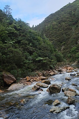
James Cook and Joseph Banks rowed up the Waihou River on 20 November 1769 and disembarked near Hikutaia. They were impressed by the kahikatea which formed a dense forest in the area. Banks described it as "the finest timber my Eyes ever beheld".[4]
In 1794, acting on Cook's description of the forest, Captain Dell and his crew of the ship Fancy camped in a place they called Graves End, which is now Hikutaia, and took 213 kahikatea trees with assistance from local Māori. At least five ships came for more timber by the end of the century. Four Europeans were living at Hikutaia in 1799, assisting the trade in timber and the sale of Māori labour. These men lived with and married Māori.[5] Cultural misunderstandings between traders and Māori sometimes led to violence.[6]
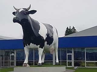
Hikutaia was known for its cheese factory in the mid 1960s.[7] The factory opened in 1917.[8]
Marae
Hikutaiā Marae is a traditional meeting ground for the local Ngāti Maru tribe.[9]Ngāti Paoa have also traditionally lived in the area.[5]
Education
Hikutaia School is a coeducational full primary (years 1-8) school with a decile rating of 4 and a roll of 86.[10]
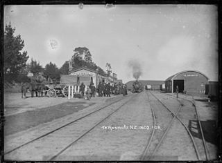
Railway station
Hikutaia station
Hikutaia had a railway station from 1898 to 1995 on the Thames Branch. Larkins and O'Brien built the Kopu to Hikutaia section from August 1885 for £10,879,[11] had made good progress by January 1886[12] and completed that section in May 1887.[13] Heath and Irwin started building the Hikutaia to Paeroa section in January 1887.[14][15] The road to the station was built in 1888.[16] Work on the Paeroa to Te Aroha section began in 1892,[17] but in 1895 it was said, "a Parliamentary faction stopped the workers in their work".[18] Work on the bridges resumed in 1897,[19] including the Hikutaia River bridge, with spans of 3 x 40ft (12m), 13ft (4.0m), and 11ft (3.4m).[20] The Minister of Public Works was able to travel by train from Hikutaia to Thames in July 1897.[21]
Hikutaia station site in 2023
The Thames to Paeroa section of the line opened on Monday, 19 December 1898,[16] with Hikutaia as a flag station.[22] It had a partly built 6th class station (a shelter shed), 200ft (61m) x 12ft (3.7m) passenger platform, 20ft (6.1m) x 30ft (9.1m) goods shed with verandah, loading bank, cattle and sheep yards. A year later there were also urinals and a passing loop for 50 wagons.[16] In 1906 the siding was extended, but goods were being stolen, as the goods shed wasn't locked and the station was unstaffed. Security improved in 1914, when a tablet porter was appointed[23] and lighting was added in 1915.[16] Signals were installed in 1916 and 1919.[23] In 1920 it was said the station was sometimes beyond its capacity and improvements were needed.[24]
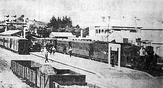
As government gave support to roads and cut railway spending, decline started, tablet working ending in 1930, with only 3 mixed trains a day each way between Paeroa and Thames, the porter moved to Auckland, the tablet equipment to Mangapehi[23] and passenger trains withdrawn on 28 March 1951.[22] The crossing loop was reduced to 37 wagons in 1958, the platform was removed in September 1959 and the privy and urinal in November 1959.[23] In the 1960s the cheese factory at Wharepoa started sending its cheese from Hikutaia, rather than Wharepoa Road.[25] By 1965 the main traffic was coal to New Zealand Co-operative Dairy Company and produce from it. From 17 July 1966 only traffic in wagon loads was handled and the station building and goods shed were sold on 19 April 1967 and the 2 railway houses in 1969. The stock yards were unused in 1971 and closed in March 1972, when they too were sold. The crossing loop was out of use by 1974 and removed in January 1976,[23] though another record says it was still in place in 1981.[22] By 1980, only 982 tonnes were carried, all of it lime and fertiliser.[23] On Sunday, 26 April 1981 Hikutaia closed to all traffic.[22] However, in July 1982, it re-opened for maintenance trains. June 28, 1991, was the last day of commercial traffic on the Thames branch and the line officially closed on March 29, 1995.[23] It is now used by the Hauraki Rail Trail.[26]
Matamata is a town in Waikato, New Zealand. It is located near the base of the Kaimai Ranges, and is a thriving farming area known for Thoroughbred horse breeding and training pursuits. It is part of the Matamata-Piako District, which takes in the surrounding rural areas, as well as Morrinsville and Te Aroha. State Highway 27 and the Kinleith Branch railway run through the town. The town has a population of 8,700 as of June 2022.
Morrinsville is a provincial town in the Waikato region of New Zealand's North Island, with an estimated population of 8,520 as of June 2022. The town is located at the northern base of the Pakaroa Range, and on the south-western fringe of the Hauraki Plains. Morrinsville is around 33 kilometres east of Hamilton and 22 kilometres west of Te Aroha. The town is bordered by the Piako River to the east and the Waitakaruru Stream to the south.
Te Aroha is a rural town in the Waikato region of New Zealand with a population of 3,906 people in the 2013 census, an increase of 138 people since 2006. It is 53 km (33 mi) northeast of Hamilton and 50 km (31 mi) south of Thames. It sits at the foot of 952 metres (3,123 ft) Mount Te Aroha, the highest point in the Kaimai Range.
Takapau is a small rural community in the Central Hawkes Bay in New Zealand. It is located 20 kilometres west of Waipukurau, off State Highway 2, and has a population of more than 500.
Putāruru is a small town in the South Waikato District and the Waikato region of New Zealand's North Island. It lies on the western side of the Mamaku Ranges and in the upper basin of the Waihou River. It is on the Oraka Stream 65 kilometres south-east of Hamilton. State Highway 1 and the Kinleith Branch railway run through the town.
The East Coast Main Trunk (ECMT) is a railway line in the North Island of New Zealand, originally running between Hamilton and Taneatua via Tauranga, connecting the Waikato with the Bay of Plenty. The ECMT now runs between Hamilton and Kawerau, with a branch line to Taneatua from the junction at Hawkens. The line is built to narrow gauge of 1,067 mm, the uniform gauge in New Zealand. It was known as the East Coast Main Trunk Railway until 2011, when the word "Railway" was dropped.
Matatoki is a locality on the Hauraki Plains of New Zealand. It lies on State Highway 26, south east of Thames and north of Paeroa. The Matatoki Stream runs from the Coromandel Range through the area to join the Waihou River.
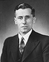
Robert Coulter was a New Zealand politician of the Labour Party.
The Thames Branch railway line connected Thames, New Zealand, with Hamilton and was originally part of the East Coast Main Trunk railway. Part of the line between Morrinsville and Waitoa remains open and is in use as the Waitoa Branch line, connecting to the Fonterra Dairy Factory at Waitoa.
The Waitawheta River is a river of the Waikato Region of New Zealand's North Island. It flows from a point south-east of Mount Te Aroha in the Kaimai Range to the Karangahake Gorge at the foot of the Coromandel Peninsula to reach the Ohinemuri River at Karangahake, five kilometres east of Paeroa.
Te Kumi railway station was a station on the North Island Main Trunk in New Zealand. The railway had been delayed by Māori opposition to it entering King Country and Te Kumi was one of the last places where such resistance was shown.
Ohinemuri County was one of the counties of New Zealand of the North Island.
Te Awamutu was a temporary terminus, serving the border town of Te Awamutu, on the North Island Main Trunk (NIMT) in New Zealand from 1880, when the line was extended from Ōhaupō, until 1887, when the line was extended south to Ōtorohanga.
The Paeroa-Pokeno railway line or deviation in the upper North Island of New Zealand between Paeroa on the East Coast Main Trunk (ECMT) and Pokeno on the North Island Main Trunk (NIMT) was a proposed route with construction started but abandoned. The proposal has been revived in recent years as part of a more direct route between Auckland and Tauranga.
Paeroa railway station is a former railway station in Paeroa; on the Thames Branch, and on the East Coast Main Trunk Railway to Waihi. Between 1895 and 1991 Paeroa had a station at the north end of the town centre, followed by one further north, another back near the town centre and then another over a mile south of the town.
The Northern Steam Ship Company Ltd (NSS) served the northern half of the North Island of New Zealand from 1881 to 1974. Its headquarters, the Northern Steam Ship Company Building, remains in use on Quay St, Auckland as a bar.
Tirohia is a rural community in the Hauraki District and Waikato region of New Zealand's North Island. It was one of the main areas used by Ngāti Hako, including Te Rae o te Papa pā. A bridge was built over the Waihou River in 1919.
Kiwitahi is a rural community in the Matamata-Piako District and Waikato region of New Zealand's North Island, located directly south of Morrinsville.
Eureka is a rural settlement in the Waikato District and Waikato region of New Zealand's North Island. It is located on State Highway 26, and is surrounded by dairy farmland on a flat plain.
Motumaoho is a small village in the Waikato region of New Zealand's North Island, just to the west of the Pakaroa Range. It is on SH26, 25 km (16 mi) east of Hamilton and 7 km (4.3 mi) west of Morrinsville. The village is bordered by the Waitakaruru Stream to the east. Motumaoho can be translated as an intruding clump of trees.
This page is based on this Wikipedia article Text is available under the CC BY-SA 4.0 license; additional terms may apply. Images, videos and audio are available under their respective licenses.