
Great Barrier Island lies in the outer Hauraki Gulf, New Zealand, 100 kilometres (62 mi) north-east of central Auckland. With an area of 285 square kilometres (110 sq mi) it is the sixth-largest island of New Zealand and fourth-largest in the main chain. Its highest point, Mount Hobson, is 627 metres (2,057 ft) above sea level. The local authority is the Auckland Council.

The Wellington Region is a local-government region of New Zealand that occupies the southern end of the North Island. The region covers an area of 8,049 square kilometres (3,108 sq mi), and has a population of 542,000.
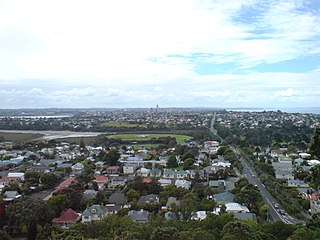
The North Shore is a part of the urban area of Auckland, New Zealand, located to the north of the Waitematā Harbour. From 1989 until 2010, North Shore City was an independent city within the Auckland Region.

Ninety Mile Beach is on the western coast of the far north of the North Island of New Zealand. The beach is actually 88 kilometres long. Its southern end is close to the headland of Reef Point, to the west of Ahipara Bay, near Kaitaia. From there it sweeps briefly northeast before running northwest along the Aupouri Peninsula for the majority of its length. It ends at Scott Point, 5 kilometres (3 mi) south of Cape Maria van Diemen and about 10 kilometres (6 mi) south of Cape Reinga.
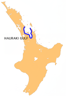
The Hauraki Gulf / Tīkapa Moana is a coastal feature of the North Island of New Zealand. It has an area of 4000 km2, and lies between, in anticlockwise order, the Auckland Region, the Hauraki Plains, the Coromandel Peninsula, and Great Barrier Island. Most of the gulf is part of the Hauraki Gulf Marine Park.
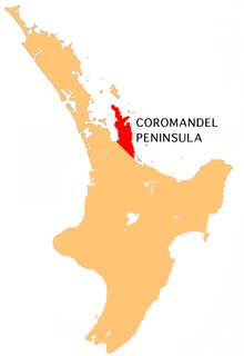
The Coromandel Peninsula on the North Island of New Zealand extends 85 kilometres (53 mi) north from the western end of the Bay of Plenty, forming a natural barrier protecting the Hauraki Gulf and the Firth of Thames in the west from the Pacific Ocean to the east. It is 40 kilometres (25 mi) wide at its broadest point. Almost its entire population lies on the narrow coastal strips fronting the Hauraki Gulf and the Bay of Plenty. In clear weather the peninsula is clearly visible from Auckland, the country's biggest city, which lies on the far shore of the Hauraki Gulf, 55 kilometres (34 mi) to the west. The peninsula is part of the Thames-Coromandel District of the Waikato region.
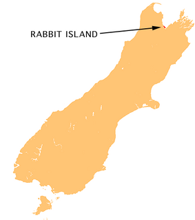
Moturoa / Rabbit Island is a small island that lies across the southernmost part of Tasman Bay / Te Tai-o-Aorere, on the northern coast of New Zealand's South Island. The long narrow island runs east–west for 8 kilometres (5 mi), and covers 15 km2 (5.8 sq mi).

The Mercury Islands are a group of seven islands off the northeast coast of New Zealand's North Island. They are located 8 kilometres (5 mi) off the coast of the Coromandel Peninsula, and 35 kilometres (22 mi) northeast of the town of Whitianga.

Beachlands is an outer suburb of Auckland, New Zealand, established in the 1920s, where development increased in the 1950s due to its popularity as a beach holiday destination. It is located on the "Pohutukawa Coast" and in close proximity to Maraetai.

Beach Haven is a suburb of Auckland, New Zealand, and is located in the North Shore north-west of the Auckland CBD. The area has gentrified rapidly over recent years as young professionals moved into the area.
The Mokohinau Islands (Pokohinau) are a small group of islands that lie off the northeast coast of New Zealand's North Island. The islands are 100 km (62 mi) northeast of Auckland, 21 km (13 mi) northwest of Great Barrier Island and approximately 52 km (32 mi) east of Bream Head. The main islands of the group include Fanal Island (Motukino), Burgess Island (Pokohinu), Flax Island (Hokoromea), and Trig Island (Atihau). Most of them are managed by the Department of Conservation as nature reserves and wildlife sanctuaries. Landing is not allowed without a permit, with the exception of Burgess Island, much of which is managed as a scenic reserve by the Department of Conservation. The remainder of Burgess Island is Crown Land and is administered by the Ministry of Transport. The total land area of the Mokohinau Islands is 160 ha.

Auckland Council is the local government council for the Auckland Region in New Zealand. It is a territorial authority that has the responsibilities, duties and powers of a regional council and so is a unitary authority, according to the Local Government Act 2009, which established the Council. The governing body consists of a mayor and 20 councillors, elected from 13 wards. There are also 149 members of 21 local boards who make decisions on matters local to their communities. It is the largest council in Oceania, with a $3 billion annual budget, $29 billion of ratepayer equity, and 9,870 full-time staff as of 30 June 2016. The council began operating on 1 November 2010, combining the functions of the previous regional council and the region's seven city and district councils into one "super council" or "super city".

Akuaku, also known as Aku Aku, was a settlement approximately halfway between Waipiro Bay and Whareponga in the East Coast region of New Zealand's North Island. A traditional landing point for waka taua, the town is most notable now as the former home of Major Ropata Wahawaha, N.Z.C, as well as the ancestral home of Te Whānau-a-Rākairoa.
Whangapoua is a small settlement of mostly holiday houses on the Coromandel Peninsula of New Zealand. It is situated 25 minutes drive east over the Coromandel Range from Coromandel along the northeastern coastline encompassing popular white sand beaches New Chums Beach, Matarangi, Kuaotunu Beach and Otama Beach.

Otama Beach is a beach on the northeast coast of the Coromandel Peninsula, New Zealand, 20 km north of Whitianga.

Rakitu Island is an uninhabited 253 ha island off the northeast coast of Great Barrier Island in the Auckland Region of New Zealand. The island is also referred to as "Arid Island" and lies about 4 km (2.5 mi) off Whangapoua Beach, sheltering the bay of Whangapoua Creek.

Onetangi is a settlement on the north coast of Waiheke Island in New Zealand. It has a long white-sand beach fronting onto Onetangi Bay.
Medlands Beach is in Oruawharo Bay on the east coast of Great Barrier Island in the Auckland Region of New Zealand. Auckland Council describes it as the most accessible beach on the island. It is one of the island's main tourist areas but is little developed. The small settlement of Medlands consists of permanent houses and holiday baches, some behind the dunes, sheltered from winds from the sea, and others elevated for a view.
Claris is a settlement on the east coast of Great Barrier Island in the Auckland Region of New Zealand. Though less populous than the main seaport area of Tryphena on the west coast, Claris functions as the administrative centre for the island, and a large proportion of its commercial and community services are based there.
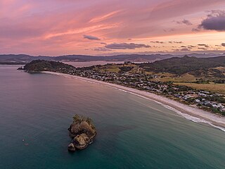
Whangapoua Beach is a beach on the east coast of Great Barrier Island in New Zealand's Hauraki Gulf.
