Related Research Articles

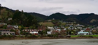
Coromandel, also called Coromandel town to distinguish it from the wider district, is a town on the Coromandel Harbour, on the western side of the Coromandel Peninsula, which is in the North Island of New Zealand. It is 75 kilometres east of the city of Auckland, although the road between them, which winds around the Firth of Thames and Hauraki Gulf coasts, is 190 km long. The population was 1,860 as of June 2020.

The Thames-Coromandel District is a territorial authority district in the North Island of New Zealand, covering all the Coromandel Peninsula and extending south to Hikutaia.

Hauraki District is a territorial authority within the Hauraki region of New Zealand. The seat of the council is at Paeroa.

Mangatainoka is a small settlement in the Tararua District of New Zealand's North Island. It is located on the banks of the Mangatainoka River, 5 km (3.1 mi) north of Pahiatua.
Ascot Park is a suburb of Porirua City approximately 22 kilometres (14 mi) north of Wellington in New Zealand.
Onepoto is a suburb of Porirua City in New Zealand. It is bounded to the north by Whitireia Park, a large park which is slowly being returned to native bush, and to the east by the Porirua Harbour.
Aotea is a suburb of Porirua.
Atawhai is one of the suburbs of Nelson, New Zealand. It lies north of Nelson and is the location of Wakapuaka Cemetery, a burial place since 1861. It also has a coastline on Nelson Haven and access to Boulder Bank from State Highway 6.
Kenleith is a rural settlement in the South Waikato District and Waikato region of New Zealand's North Island. It includes the Kinleith Mill.
Bishopdale is one of the suburbs of Nelson, New Zealand.
Washington Valley is a major inner suburb of Nelson, New Zealand. It lies to the west of Nelson city centre between Stepneyville and Beachville.
Stepneyville is a suburb of Nelson, New Zealand.
Maitai is an inner suburb of Nelson, New Zealand. It lies at the western edge of Nelson city centre, immediately to the south of The Wood, on the northern bank of the Maitai River. A monument representing the location of the geographic centre of New Zealand is located in Maitai.
Enner Glynn is a suburb of Nelson, New Zealand. It lies to the south of Nelson city centre and east of Stoke, inland from Wakatu.
Maitlands is one of the suburbs of Nelson, New Zealand. It lies to the east of Stoke, immediately to the west of Enner Glynn.
Annesbrook is an industrial suburb of Nelson, New Zealand.
Nayland is a suburb of Stoke, New Zealand. It lies to the north of Stoke, close to Nelson Airport, southwest of Nelson city centre.
Monaco is a small suburb of Nelson, west of town centre of Stoke. It lies on a narrow peninsula which extends into Tasman Bay / Te Tai-o-Aorere immediately to the south of Nelson Airport, southwest of central Nelson.
Saxton is a suburb of Nelson, south of Stoke and northwest of Richmond.
Kopu is a settlement in on the Coromandel Peninsula in New Zealand's North Island. It is located near Thames, in the Thames-Coromandel District in the Waikato region.
References
- ↑ "Statistical Area 2 2018 (generalised) GIS" (Data table). stats.govt.nz. Statistics New Zealand.
- 1 2 3 4 5 "Place Summary - Kauaeranga". Stats NZ. Statistics New Zealand.
- ↑ "Provisional Statistics". stats.govt.nz. Statistics New Zealand.
Coordinates: 37°08′43″S175°35′25″E / 37.1453702°S 175.5902866°E