Square Kauri

Last updated
Square Kauri Square Kauri trunk 2.jpg
Square Kauri

The Square Kauri is an estimated 1,200 year old kauri tree (Agathis australis) in the Coromandel Range on the Coromandel Peninsula, New Zealand. It is the 15th largest kauri on the peninsula [1]

<i>Agathis australis</i> species of plant

Agathis australis, commonly known by its Māori name kauri, is a coniferous tree of Araucariaceae in the genus Agathis, found north of 38°S in the northern districts of New Zealand's North Island.

Coromandel Range mountain range in New Zealand

The Coromandel Range is a ridge of rugged hills running the length of the Coromandel Peninsula in the North Island of New Zealand. It is located 60 kilometres (37 mi) east of the city of Auckland, and runs north-south for approximately 85 kilometres. The highest point in the range is Mount Moehau, at the northern end of the peninsula within the Moehau Range. There are numerous peaks over 600 metres in height.

Coromandel Peninsula peninsula in New Zealand

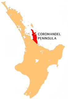
The Coromandel Peninsula on the North Island of New Zealand extends 85 kilometres north from the western end of the Bay of Plenty, forming a natural barrier to protect the Hauraki Gulf and the Firth of Thames in the west from the Pacific Ocean to the east. It is 40 kilometres wide at its broadest point. Almost the entire population lies on the narrow coastal strips fronting the Hauraki Gulf and the Bay of Plenty. In clear weather the peninsula is clearly visible from Auckland, the country's biggest city, which lies on the far shore of the Hauraki Gulf, 55 kilometres to the west. The peninsula is part of the local government areas of Thames-Coromandel District and the Waikato Region and is part of the Regional Tourism Organisation representing The Coromandel.

The Square Kauri is a popular stop along the "Tapu-Coroglen Road", as it is only a short walk from the road. Its unusual square-looking trunk spared it from felling when most of the large kauri trees in the area were logged during the late 19th century.

Tapu, New Zealand Place in Waikato, New Zealand

Tapu is a locality on the western side of the Coromandel Peninsula of New Zealand. State Highway 25 runs through it. Coromandel is 35 km to the north, and Thames is 19 km to the south. The Tapu River flows from the Coromandel Range past the settlement and into the Firth of Thames to the west.

Coroglen Place in Waikato, New Zealand

Coroglen is a locality in the Coromandel Peninsula, New Zealand. It lies on State Highway 25, 18 kilometres south of Whitianga and 26 kilometres north west of Tairua. The "Tapu-Coroglen Road", a windy gravel road, connects it across the Coromandel Range with Tapu on the west coast of the peninsula.

Trunk (botany) main wooden axis of a tree

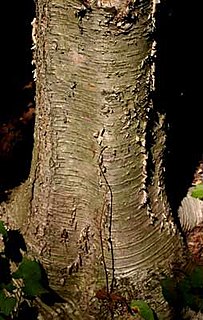
In botany, the trunk is the stem and main wooden axis of a tree, which is an important feature in tree identification, and which often differs markedly from the bottom of the trunk to the top, depending on the species. The trunk is the most important part of the tree for timber production.

Measurements

Trunk girth 8.76 m (28.7 ft)
Clean bole12.8 m (42 ft)
Trunk volume69.8 m3 (2,460 cu ft) [2]

All the measurements above were taken in 1975. [2]

Related Research Articles

Great Barrier Island largest island near New Zealands North Island

Great Barrier Island lies in the outer Hauraki Gulf, New Zealand, 100 kilometres (62 mi) north-east of central Auckland. With an area of 285 square kilometres (110 sq mi) it is the sixth-largest island of New Zealand and fourth-largest in the main chain. Its highest point, Mount Hobson, is 627 metres (2,057 ft) above sea level. The local authority is the Auckland Council.

Coromandel, New Zealand Place in Waikato, New Zealand

Coromandel or Coromandel Town is a town on the Coromandel Harbour, on the western side of the Coromandel, which is in the North Island of New Zealand. It is 75 kilometres east of the city of Auckland, although the road between them, which winds around the Firth of Thames and Hauraki Gulf coasts, is 190 km long. The population was 1,750 as of June 2018.

Waipoua Forest

Waipoua Forest preserves some of the best examples of kauri forest remaining in New Zealand. It is notable for having two of the largest living kauri trees, Tāne Mahuta and Te Matua Ngahere. The forest was declared a sanctuary in 1952. A community-based volunteer organisation, the Waipoua Forest Trust, helps maintain the forest.

Thames-Coromandel District Territorial authority in Waikato, New Zealand

The Thames-Coromandel District is a territorial authority district in the North Island of New Zealand, covering all the Coromandel Peninsula and extending south to Hikutaia.

Colville, New Zealand Place in Waikato, New Zealand

Colville, a small town in the north of the Coromandel Peninsula in the North Island of New Zealand, lies 26 kilometres north of Coromandel in Colville Bay on the Hauraki Gulf, and is the northernmost town of any note on the peninsula. North of Colville, 28 kilometres of rough road lead to the small settlement of Port Jackson, close to the peninsula's northwesternmost point, Cape Colville and 20 km to Port Charles on the northeastern side.

Whitianga Place in Waikato, New Zealand

Whitianga is a town on the Coromandel Peninsula, in the Waikato Region of New Zealand's North Island. The town is located on Mercury Bay, on the northeastern coast of the peninsula. The town has a permanent population of 5,080 as of June 2018, making it the second-largest town on the Coromandel Peninsula behind Thames.

Tāne Mahuta

Tāne Mahuta is a giant kauri tree in the Waipoua Forest of Northland Region, New Zealand. Its age is unknown but is estimated to be between 1,250 and 2,500 years. It is the largest kauri known to stand today. It is named for the Māori god of forests and of birds.

Hahei Place in Waikato, New Zealand

Hahei is a small settlement in Mercury Bay on the eastern side of the Coromandel Peninsula in New Zealand. It is near Cathedral Cove, between the settlements of Cooks Beach and Hot Water Beach. It is approximately 6 km south east of Whitianga and 6 km north of Hot Water Beach.

Manaia, Waikato Place in Waikato, New Zealand

Manaia is a locality on the western side of the Coromandel Peninsula of New Zealand. It lies to the east of State Highway 25, south of Coromandel and north of Tapu. The Manaia River flows from the Coromandel Range through the area and into the Manaia Harbour to the west. The harbour contains mussel farms.

The 309 Road is a 22-kilometre (14 mi) gravel road between the towns of Coromandel and Whitianga in New Zealand. It winds its way from Coromandel, on the west side of the Coromandel Peninsula, over the ranges to Whitianga, on the eastern side. There are two theories as to how it got its name: one is that there are 309 bends in the road, the other is that horse-drawn coaches used to take 309 minutes to travel it.

The Siamese Kauri is a kauri tree growing in Kauri Grove, about 10 kilometres south of Coromandel township in the north-east of the North Island of New Zealand. The tree gains its name from the conjoined lower trunk that the two trees share. It grows in the Kauri Grove, one of the few remaining stands of mature kauri on the Coromandel Peninsula. It is about 500 metres off the 309 Road, and is accessed by a 30-minute walking track.

The Tapu River is a river of the Coromandel Peninsula in New Zealand's North Island. It flows west from the Coromandel Range, reaching the Firth of Thames at the settlement of Tapu, approximately halfway between Thames and Coromandel.

Waitawheta River river in New Zealand

The Waitawheta River is a river of the Waikato Region of New Zealand's North Island. It flows from a point south-east of Mount Te Aroha in the Kaimai Range to the Karangahake Gorge at the foot of the Coromandel Peninsula to reach the Ohinemuri River at Karangahake, five kilometres east of Paeroa.

Driving Creek Railway

The Driving Creek Railway is a narrow gauge bush and mountain railway on the outskirts of the provincial town of Coromandel on the northwestern coast of the Coromandel Peninsula on New Zealand's North Island. The railway leads up the mountain to a viewing platform building 165 m high above the surrounding Coromandel west coast country.

Te Mata, Thames-Coromandel District human settlement in New Zealand

Te Mata is a small village on the western coast of the Coromandel Peninsula, New Zealand, located approximately halfway between Coromandel Town and Thames. It overlooks Te Mata River.

Whangapoua Place in Waikato, New Zealand

Whangapoua is a small settlement of mostly holiday houses on the Coromandel Peninsula of New Zealand. It is situated 25 minutes drive east over the Coromandel Range from Coromandel along the northeastern coastline encompassing popular white sand beaches New Chums Beach, Matarangi, Kuaotunu Beach and Otama Beach.

References

  1. "Square Kauri Tree". Department of Conservation. Retrieved 2013-03-02.
  2. 1 2 "Coromandel Giants". Kauri 2000 Trust. Retrieved 2013-03-02.

Coordinates: 36°59′25″S175°34′22″E / 36.990278°S 175.572667°E / -36.990278; 175.572667

Geographic coordinate system Coordinate system

A geographic coordinate system is a coordinate system that enables every location on Earth to be specified by a set of numbers, letters or symbols. The coordinates are often chosen such that one of the numbers represents a vertical position and two or three of the numbers represent a horizontal position; alternatively, a geographic position may be expressed in a combined three-dimensional Cartesian vector. A common choice of coordinates is latitude, longitude and elevation. To specify a location on a plane requires a map projection.