Whanganui Island

Last updated

Whanganui Island
Whanganui Island
Geography
Location Hauraki Gulf
Coordinates 36°47′S175°26′E / 36.783°S 175.433°E / -36.783; 175.433
Area2.83 km2 (1.09 sq mi)
Administration
New Zealand
Demographics
Population?

Whanganui Island is the largest of a small group of islands at the entrance to Coromandel harbour in the Hauraki Gulf, off the coast of New Zealand's North Island.

Contents

The island, which is privately owned, is 2.83 square kilometres (1.09 sq mi) in area. Much of it is farmed, but there are some forested areas.

Early history

The ancient of Horokino (Herekino) situated at Arapaoa Bay (Homestead Bay) was captured by the Tainui from the original inhabitants, the Ngāti Huarere, and was one of several dotted around the perimeter of the Coromandel Harbour, then known as the Waiau. [1]

Horokino (Herekino) Pa situated at Arapaoa or Aropawa Bay (Homestead Bay) Whanganui Island Horokino ( Herekino) Pa situated at Arapaoa or Aropawa Bay ( Homestead Bay) Whanganui Island Aotearoa.jpg
Horokino (Herekino) Pā situated at Arapaoa or Aropawa Bay (Homestead Bay) Whanganui Island

Modern history

The geographic naming by both Māori and Pākehā has been subject to many changes over the history of the island and this makes the study of its history confusing.

The historian A. V. Piesse made a study of the names and seems to have arrived at a suitable summary. "The island is separated from the mainland by a narrow passage known as Whenuakura.The ancient name for the Island was Poroporo (according to Church Missionary Society catechist James Preece), later referred to by early settlers as Arapaoa, and then finally Whanganui Island (although originally as Wanganui Island). Also the Southernmost Point of the Island, now called Tawhiti Point was originally named Poroporo. Tawhiti Point was the name first used for the Northern end of Tawhiti (Woolshed) Bay, which is now called Rodney Point. [2] The island was variously also named Beesons Island, [3] Parker Island [4] and Waiou. [5]

Arapaoa Bay Coromandel Harbour NZ, A sketch (1848?) by J J Merrett Arapaoa Bay Coromandel Harbour NZ, A sketch ( 1848) J J Merrett Alexander Turnbull Library A-143-104.jpg
Arapaoa Bay Coromandel Harbour NZ, A sketch (1848?) by J J Merrett
Arapaoa Bay from the house looking out onto the Coromandel Harbour. William Webster's base and John Logan Campbell's home for a period Arapaoa Bay from the house looking out onto the Coromandel Harbour.jpg
Arapaoa Bay from the house looking out onto the Coromandel Harbour. William Webster's base and John Logan Campbell's home for a period

American William Webster established a shipbuilding and trading enterprise on the island in 1836. [6] He owned the island until the signing of the Treaty of Waitangi, when he lost legal title to the island as all titles passed to the British crown.[ citation needed ]

During the period of William Webster John Logan Campbell spent a period of time on Whanganui Island. There is a certain amount of confusion about where he stayed. Some say he lived at Timber (Woolshed) Bay and some say he stayed at the home at Arapaoa Bay. There was a good deal of shipbuilding activity in Timber (Woolshed) Bay [7] and this was of primary interest to Campbell so it was possible that he stayed there. However Piesse for one includes a sketch of Campbell's "base" in his book [8] and Campbell writes about his "Stay at Herekino" [9] in his book "Poenamo" [10]

Town of Coromandel

Whanganui Island was the original site for the new Town of Coromandel. Plans were drawn up and sold in New Zealand and Britain.

Sale of Sections at the new town of Coromandel on Whanganui Island beginning 7 August 1862 Sale of Sections at Coromandel ( Whanganui Island) The New Zealander Paper Auckland Wed August 6 1862.jpg
Sale of Sections at the new town of Coromandel on Whanganui Island beginning 7 August 1862

and sections were sold. The issue to the new owners was that the plan implied flattish land but the land was far from flat. There was also no suitable permanent source of fresh water.

Name Coromandel Town written on Plan on Whanganui Island Aotearoa Original Plan including Kapanga Coromandel Town Aotearoa Original Plan including Kapanga.jpg
Name Coromandel Town written on Plan on Whanganui Island Aotearoa Original Plan including Kapanga

.The new owners abandoned their land and eventually the Crown bought all but two of the sections and helped the Settlers establish themselves in the mainland settlement of Kapanga (the new Coromandel Town )

. The land in this photo approximately corresponds to the land in the town plan. Woolshed Bay is the next Bay past the anchored yachts before ridge covered with trees. Woolshed Bay the next Bay past the anchored yachts before ridge covered with trees Whanganui Island Coromandel Harbour.jpg
. The land in this photo approximately corresponds to the land in the town plan. Woolshed Bay is the next Bay past the anchored yachts before ridge covered with trees.

Woolshed Bay on the protected southern shore is a popular overnight mooring spot for cruising from Auckland.

See also

Related Research Articles

<span class="mw-page-title-main">Coromandel, New Zealand</span> Town in Waikato, New Zealand

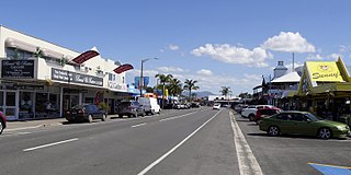
Coromandel, also called Coromandel Town to distinguish it from the wider district, is a town on the Coromandel Harbour, on the western side of the Coromandel Peninsula, which is in the North Island of New Zealand. It is 75 kilometres east of the city of Auckland, although the road between them, which winds around the Firth of Thames and Hauraki Gulf coasts, is 190 km long. The population was 1,930 as of June 2023.

<span class="mw-page-title-main">Poor Knights Islands</span> Group of islands and marine reserve off the east coast of New Zealands North Island

The Poor Knights Islands are a group of islands off the east coast of the Northland Region of the North Island of New Zealand. They lie 50 kilometres (31 mi) to the northeast of Whangārei, and 22 kilometres (14 mi) offshore halfway between Bream Head and Cape Brett. Uninhabited since the 1820s, they are a nature reserve and popular underwater diving spot, with boat tours typically departing from Tutukaka. The Poor Knights Islands Marine Reserve surrounds the island.

<span class="mw-page-title-main">Wellington Harbour</span> Harbour in New Zealand

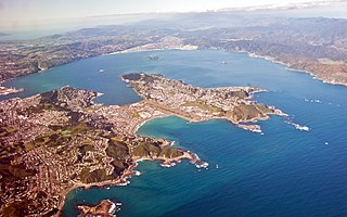
Wellington Harbour is a large natural harbour on the southern tip of New Zealand's North Island. The harbour entrance is from Cook Strait. Central Wellington is located on parts of the western and southern sides of the harbour, and the suburban area of Lower Hutt is to the north and east.

<span class="mw-page-title-main">Tory Channel</span> Channel in New Zealand

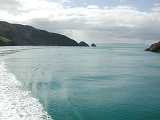
Tory Channel is one of the drowned valleys that form the Marlborough Sounds in New Zealand. Inter-island ferries normally use it as the principal channel between Cook Strait and the Marlborough Sounds.

<span class="mw-page-title-main">Coromandel Peninsula</span> Peninsula in New Zealand

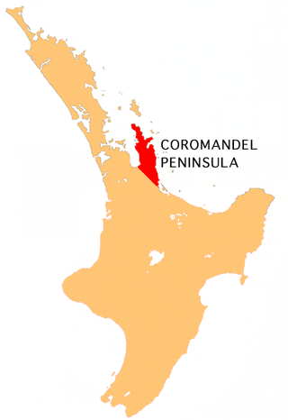
The Coromandel Peninsula on the North Island of New Zealand extends 85 kilometres (53 mi) north from the western end of the Bay of Plenty, forming a natural barrier protecting the Hauraki Gulf and the Firth of Thames in the west from the Pacific Ocean to the east. It is 40 kilometres (25 mi) wide at its broadest point. Almost its entire population lives on the narrow coastal strips fronting the Hauraki Gulf and the Bay of Plenty. In clear weather the peninsula is clearly visible from Auckland, the country's biggest city, which lies on the far shore of the Hauraki Gulf, 55 kilometres (34 mi) to the west. The peninsula is part of the Thames-Coromandel District and the Waikato Region.

<span class="mw-page-title-main">John Logan Campbell</span> New Zealand politician (1817–1912)

Sir John Logan Campbell was a Scottish-born New Zealand public figure. He was described by his contemporaries as "the father of Auckland".

<span class="mw-page-title-main">Cape Campbell</span>

Cape Campbell, Te Rae-o-te-kōhaka in the Māori language, is in Marlborough, New Zealand, on the northeastern coast of the South Island. It lies at the southern end of Clifford Bay, 15 kilometres (9 mi) northeast of Ward, and 42 kilometres (26 mi) southeast of Blenheim. Cape Campbell lies close to the salt works at Lake Grassmere.

<span class="mw-page-title-main">Mercury Bay</span> Bay in New Zealand

Mercury Bay is a large V-shaped bay on the eastern coast of the Coromandel Peninsula on the North Island of New Zealand. It was named by the English navigator Captain James Cook during his exploratory expeditions. It was first named Te-Whanganui-a-Hei, the great bay of Hei, by the Māori.

<span class="mw-page-title-main">Whitianga</span> Town in Waikato, New Zealand

Whitianga is a town on the Coromandel Peninsula, in the Waikato region of New Zealand's North Island. The town is located on Mercury Bay, on the northeastern coast of the peninsula. The town has a permanent population of 6,440 as of June 2023, making it the second-largest town on the Coromandel Peninsula behind Thames.

<span class="mw-page-title-main">Whanganui A Hei (Cathedral Cove) Marine Reserve</span> Beach and marine reserve in New Zealand

Te Whanganui-A-Hei Marine Reserve is in the southern part of Mercury Bay on the Coromandel Peninsula in New Zealand covering an area of 840 hectares. On the coast of the mainland, it stretches from Cook Bluff in the north-west to the northern end of Hahei Beach in the south-east. Its offshore extremes run from Motukorure Island through Waikaranga Island to Okorotere Island and the northern end of Mahurangi Island.

<span class="mw-page-title-main">Motukorea</span> Island near Auckland, New Zealand

Motukorea or Browns Island is a small New Zealand island, in the Hauraki Gulf north of Musick Point, one of the best preserved volcanoes in the Auckland volcanic field. The age of eruption is about 25,000 years ago, when the Tāmaki Estuary and the Waitemata Harbour were forested river valleys. Due to centuries of cultivation, little native bush remains except on the north-eastern cliffs, leaving the volcanic landforms easily visible. It exhibits the landforms from three styles of eruption. The island consists of one main scoria cone with a deep crater, a small remnant arc of the tuff ring forming the cliffs in the northeast, and the upper portions of lava flows. The area was dry land when the eruptions occurred, but much of the lava is now submerged beneath the sea.

Whanganui, also spelled "Wanganui", is a city in the Manawatu-Wanganui Region of New Zealand.

<span class="mw-page-title-main">New Zealand place names</span> Overview of place names in New Zealand

Most New Zealand place names have a Māori or a British origin. Both groups used names to commemorate notable people, events, places from their homeland, and their ships, or to describe the surrounding area. It is unknown whether Māori had a name for the whole of New Zealand before the arrival of Europeans, but post-colonisation the name Aotearoa has been used to refer to the whole country. Dutch cartographers named the islands Nova Zeelandia, the Latin translation of the Dutch Nieuw Zeeland. By the time of British exploration, the country's name was anglicised to New Zealand.

The following lists events that happened during 1826 in New Zealand.

The first Christian mission is established at Rangihoua. The Hansen family, the first non-missionary family also settles there. Samuel Marsden explores the Hauraki Gulf and travels to within sight of Tauranga Harbour. The first book in Māori is published in Sydney. The first European is born in New Zealand.

<span class="mw-page-title-main">Tama-te-kapua</span>

In Māori tradition of New Zealand, Tama-te-kapua, also spelt Tamatekapua and Tama-te-Kapua and also known as Tama, was the captain of the Arawa canoe which came to New Zealand from Polynesia in about 1350.

<span class="mw-page-title-main">Cooks Beach</span> Place in Waikato, New Zealand

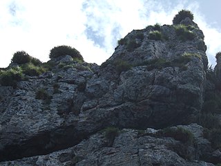
Cooks Beach (Pukaki) is a town on a three-kilometre white-sand beach on the Coromandel Peninsula of New Zealand. To its north is Cooks Bay, and beyond that is Mercury Bay. To the east is the locality of Hahei and the tourist attraction of Cathedral Cove. Roads to the south connect to SH 25. On the northwest, Shakespeare Cliff is a scenic reserve with a lookout point.

References

  1. "Whanganui Island – A History. The town that never was." A V Piesse
  2. "Whanganui Island – A History. The town that never was." A V Piesse Pages 4 & 5
  3. The New-Zealander. Wednesday August 6, 1862 Vol XVIII Issue 1711 6 August 1862 "The Wynard Pier"
  4. Parker Island Papers Past _ Newspapers _ New Zealand Times _ 18 July 1899 _ LOCAL AND GENERAL
  5. "Romance of Coromandel | NZETC".
  6. Paul Monin. "Coromandel and surrounds". Te Ara: The Encyclopedia of New Zealand. Retrieved 7 January 2018.
  7. In Timber (now Woolshed Bay) you can still see the dig out where the ships were built and Kim Ward – ex Manager of the Island told me that at low tide you could find remnants of posts sunk into the ground (about 2ft square) where they attached blocks to assist in the launching of the newly built boats – April 2020 Jim Sharp, Ruffins Bay.
  8. "Arapaoa Bay, Websters Base "Whanganui Island – A History. The town that never was." A V Piesse Page 21
  9. James Cowan (1 November 1933). "Famous New Zealanders — No. 8". The New Zealand Railways Magazine. Vol. 8, no. 7. p. 18. Retrieved 5 May 2021. In April he landed at Herekino Bay, in Waiau or Coromandel Harbour ... Campbell's description in his book "Poenamo" of Coromandel and Beeson's Island and Herekino when he arrived there in 1840
  10. Campbell, John Logan (1973). Poenamo. Golden Press Pty Ltd. ISBN   0855582774.