Whangapoua

Last updated

Whangapoua
Whangapoua Sunset.jpg
Aerial overview of Whangapoua
Whangapoua
Coordinates: 36°42′49″S175°36′54″E / 36.71361°S 175.61500°E / -36.71361; 175.61500
Country New Zealand
Region Waikato
District Thames-Coromandel District
WardMercury Bay ward
Community BoardMercury Bay Community
Government
  Council Thames-Coromandel District Council
Area
[1]
  Total0.74 km2 (0.29 sq mi)
Population
 (June 2023) [2]
  Total120
  Density160/km2 (420/sq mi)

Whangapoua is a small settlement of mostly holiday houses located on the Coromandel Peninsula of New Zealand. It is situated 25 minutes drive east over the Coromandel Range from Coromandel along the northeastern coastline encompassing popular white sand beaches New Chums Beach, Matarangi, Kuaotunu Beach and Otama Beach.

Contents

Amenities in Whangapoua include a small wharf and boat ramp, and a general store that also supplies petrol and diesel. The nearby estuary provides further water access for boats. Whangapoua Beach is a safe 1.5km long sandy swimming beach flanked in the north by the rocky foreshore towards Motuto Point and by Te Rehutae Point in the southeast.

The northern end of Whangapoua Beach is the starting point of a partly unformed track to New Chums Beach - that beach is only accessible via this track at low tide or by boat. The nearest school is in Te Rerenga.

History

Whangapoua's Māori history dates back to the 13th century. A reserve at Opera Point, east of Whangapoua, contains the remains of the Raukawa pa site. European settlers started arriving in the 1860s, drawn to the area chiefly for kauri milling and gold mining.

Today, Whangapoua is spread along behind the beach and consists of about 120 permanent residents, [3] but can swell to over 1000 with holiday residents during the most popular holiday period from late December to February.

Demographics

Whangapoua is described by Statistics New Zealand as a rural settlement. It covers 0.74 km2 (0.29 sq mi) [1] and had an estimated population of 120 as of June 2023, [2] with a population density of 162 people per km2. Whangapoua is part of the larger Mercury Bay North statistical area. [4]

Historical population
YearPop.±% p.a.
200654    
201342−3.53%
201875+12.30%
Source: [5]

Whangapoua had a population of 75 at the 2018 New Zealand census, an increase of 33 people (78.6%) since the 2013 census, and an increase of 21 people (38.9%) since the 2006 census. There were 33 households, comprising 42 males and 36 females, giving a sex ratio of 1.17 males per female. The median age was 61.0 years (compared with 37.4 years nationally), with 12 people (16.0%) aged under 15 years, 6 (8.0%) aged 15 to 29, 21 (28.0%) aged 30 to 64, and 36 (48.0%) aged 65 or older.

Ethnicities were 84.0% European/Pākehā, 16.0% Māori, and 8.0% other ethnicities. People may identify with more than one ethnicity.

Although some people chose not to answer the census's question about religious affiliation, 60.0% had no religion and 32.0% were Christian.

Of those at least 15 years old, 12 (19.0%) people had a bachelor's or higher degree, and 12 (19.0%) people had no formal qualifications. The median income was $21,100, compared with $31,800 nationally. 3 people (4.8%) earned over $70,000 compared to 17.2% nationally. The employment status of those at least 15 was that 15 (23.8%) people were employed full-time, 6 (9.5%) were part-time, and 3 (4.8%) were unemployed. [5]

Related Research Articles

<span class="mw-page-title-main">Coromandel, New Zealand</span> Town in Waikato, New Zealand

Coromandel, also called Coromandel Town to distinguish it from the wider district, is a town on the Coromandel Harbour, on the western side of the Coromandel Peninsula, which is in the North Island of New Zealand. It is 75 kilometres east of the city of Auckland, although the road between them, which winds around the Firth of Thames and Hauraki Gulf coasts, is 190 km long. The population was 1,930 as of June 2023.

<span class="mw-page-title-main">Thames-Coromandel District</span> Territorial authority district in Waikato, New Zealand

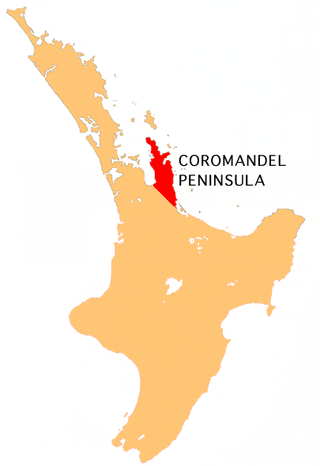
The Thames-Coromandel District is a territorial authority district in the North Island of New Zealand, covering all the Coromandel Peninsula and extending south to Hikutaia.

<span class="mw-page-title-main">Hauraki District</span> Territorial authority district in Waikato Region, New Zealand

Hauraki District is a territorial authority within the Hauraki region of New Zealand. The seat of the council is at Paeroa.

<span class="mw-page-title-main">Coromandel Peninsula</span> Peninsula in New Zealand

<span class="mw-page-title-main">Waihi Beach</span> Town in the Bay of Plenty, New Zealand

Waihi Beach is a coastal town at the western end of the Bay of Plenty in New Zealand's North Island. It lies 10 kilometres to the east of the town of Waihi, at the foot of the Coromandel Peninsula. The main beach is 10 kilometres long. The town had a permanent population of 2,780 as of June 2023.

<span class="mw-page-title-main">Pauanui</span> Place in Waikato, New Zealand

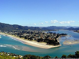
The town of Pauanui is on the east coast of the Coromandel Peninsula in the North Island of New Zealand. It lies at the mouth of the Tairua River on its south bank, directly opposite the larger town of Tairua.

<span class="mw-page-title-main">Whitianga</span> Town in Waikato, New Zealand

Whitianga is a town on the Coromandel Peninsula, in the Waikato region of New Zealand's North Island. The town is located on Mercury Bay, on the northeastern coast of the peninsula. The town has a permanent population of 6,440 as of June 2023, making it the second-largest town on the Coromandel Peninsula behind Thames.

<span class="mw-page-title-main">Whangamatā</span> Town in Waikato, New Zealand

The town of Whangamatā is on the southeast coast of the Coromandel Peninsula in the North Island of New Zealand. It is located 30 kilometres north of Waihi, to the north of the western extremity of the Bay of Plenty.

<span class="mw-page-title-main">Whiritoa</span> Settlement in Waikato, New Zealand

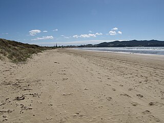
Whiritoa is a small beach town on the Coromandel Peninsula, New Zealand between Whangamatā and Waihi Beach. It has a permanent population in the low hundreds, which swells to over a thousand during the New Year holiday period.

<span class="mw-page-title-main">Purau</span> Settlement in Canterbury, New Zealand

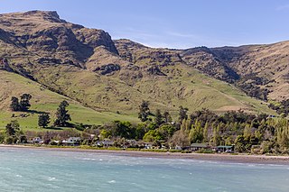
Purau is a small town in Canterbury, New Zealand, facing Lyttelton Harbour.

<span class="mw-page-title-main">Hahei</span> Place in Waikato, New Zealand

Hahei is a small settlement in Mercury Bay on the eastern side of the Coromandel Peninsula in New Zealand. It is near Cathedral Cove, between the settlements of Cooks Beach and Hot Water Beach. It is approximately 11 km south east of Whitianga and 8 km north of Hot Water Beach.

<span class="mw-page-title-main">Tapu, New Zealand</span> Rural settlement in New Zealand

Tapu is a locality on the western side of the Coromandel Peninsula of New Zealand. State Highway 25 runs through it. Coromandel is 35 km to the north, and Thames is 19 km to the south. The Tapu River flows from the Coromandel Range past the settlement and into the Firth of Thames to the west.

<span class="mw-page-title-main">Te Puru</span> Rural settlement in New Zealand

Te Puru is a locality on the western side of the Coromandel Peninsula of New Zealand. State Highway 25 runs through it. Tapu lies about 7 km to the north, and Thames is about 12 km to the south. The Te Puru Stream and about 18 tributaries drain a steep hilly 23 km2 area of the Coromandel Range, almost entirely covered by native forest. It runs through the settlement and into the Firth of Thames to the west. Flooding has been a problem.

<span class="mw-page-title-main">Matarangi</span> Place in Waikato, New Zealand

Matarangi is a beach settlement on the Coromandel Peninsula of New Zealand, with around 420 permanent residents in 2018 which increases to over 7000 holidaymakers during the summer period of late December to February. It was developed in the 1980s as a purpose-built resort town and occupies a white sand peninsula between the Whangapoua Harbour and historic Mercury Bay. It is half an hour from the towns of Coromandel to the west and Whitianga to the south east.

Kūaotunu is a small coastal township at the east coast of the Coromandel Peninsula on the mouth of the Kuaotunu River on the North Island of New Zealand.

<span class="mw-page-title-main">Onemana</span> Beach village in New Zealand

Onemana is a 1970s beach village on the eastern side of the Coromandel Peninsula of New Zealand, with a beach, a surf club, fire station and dairy. It lies 3 km (1.9 mi) to the east of State Highway 25, south of Pauanui and north of Whangamatā. The Wharekawa River and Opoutere are just to the north and west.

<span class="mw-page-title-main">Tokerau Beach</span> Place in Northland Region, New Zealand

Tokerau Beach is a settlement on the northwestern side of Doubtless Bay on the Karikari Peninsula of Northland, New Zealand.

Rings Beach is a beach settlement on the Coromandel Peninsula of New Zealand, between Matarangi on the west and Kūaotunu on the east. The eastern end of the settlement is known as Kūaotunu West.

<span class="mw-page-title-main">Waiomu</span> Rural settlement in New Zealand

Waiomu is a settlement on the west coast of the Coromandel Peninsula of New Zealand, between Tapu to the north and Te Puru to the south. State Highway 25 runs through it.

<span class="mw-page-title-main">Thornton Bay</span> Rural settlement in Waikato, New Zealand

Thornton Bay is a settlement on the west coast of the Coromandel Peninsula of New Zealand, between Te Puru to the north and Whakatete Bay to the south. State Highway 25 runs through it. Ngarimu Bay immediately to the south is considered to be part of the same urban area by Statistics New Zealand.

References

  1. 1 2 "ArcGIS Web Application". statsnz.maps.arcgis.com. Retrieved 26 August 2022.
  2. 1 2 "Subnational population estimates (RC, SA2), by age and sex, at 30 June 1996-2023 (2023 boundaries)". Statistics New Zealand . Retrieved 25 October 2023. (regional councils); "Subnational population estimates (TA, SA2), by age and sex, at 30 June 1996-2023 (2023 boundaries)". Statistics New Zealand . Retrieved 25 October 2023. (territorial authorities); "Subnational population estimates (urban rural), by age and sex, at 30 June 1996-2023 (2023 boundaries)". Statistics New Zealand . Retrieved 25 October 2023. (urban areas)
  3. Shenagh Gleeson (5 July 2012). "Coromandel Peninsula Post". The Peninsula Post. Retrieved 2 March 2013.
  4. 2018 Census place summary: Mercury Bay North
  5. 1 2 "Statistical area 1 dataset for 2018 Census". Statistics New Zealand. March 2020. 7010612.