
A beach is a landform alongside a body of water which consists of loose particles. The particles composing a beach are typically made from rock, such as sand, gravel, shingle, pebbles, etc., or biological sources, such as mollusc shells or coralline algae. Sediments settle in different densities and structures, depending on the local wave action and weather, creating different textures, colors and gradients or layers of material.

A rip current is a specific type of water current that can occur near beaches where waves break. A rip is a strong, localized, and narrow current of water that moves directly away from the shore by cutting through the lines of breaking waves, like a river flowing out to sea. The force of the current in a rip is strongest and fastest next to the surface of the water.

A rip tide, or riptide, is a strong offshore current that is caused by the tide pulling water through an inlet along a barrier beach, at a lagoon or inland marina where tide water flows steadily out to sea during ebb tide. It is a strong tidal flow of water within estuaries and other enclosed tidal areas. The riptides become the strongest where the flow is constricted. When there is a falling or ebbing tide, the outflow water is strongly flowing through an inlet toward the sea, especially once stabilised by jetties.

Piha is a coastal settlement in West Auckland, on the western coast of the Auckland Region in New Zealand. It is one of the most popular beaches in the area and a major day-trip destination for Aucklanders throughout the year, and especially in summer.

Black's Beach is a secluded section of beach beneath the bluffs of Torrey Pines on the Pacific Ocean in La Jolla, a community of San Diego, California. It is officially part of Torrey Pines State Beach. The northern portion of Black's Beach is owned and managed by the California Department of Parks and Recreation, while the southern portion of the beach, officially known as Torrey Pines City Beach, is jointly owned by the City of San Diego and the state park, and managed by the City of San Diego. This distinction is important as Black's Beach is most known as a nude beach, a practice that is now prohibited in the southern portion managed by the City of San Diego.

Huntington State Beach is a protected beach in Southern California, located in the City of Huntington Beach in Orange County. It extends 2 miles (3.2 km) from Newport Beach north to Beach Boulevard, where the Huntington City Beach begins. The 121-acre (49 ha) park was established in 1942.

Perdido Key is an unincorporated community located in Escambia County, Florida, United States, between the cities of Pensacola, Florida and Orange Beach, Alabama. The community is located on and named for Perdido Key, a barrier island in northwest Florida and southeast Alabama. "Perdido" means "lost" in the Spanish and Portuguese languages. The Florida district of the Gulf Islands National Seashore includes the east end of the island, as well as other Florida islands. No more than a few hundred yards wide in most places, Perdido Key stretches some 16 miles (26 km) from near Pensacola to Perdido Pass Bridge near Orange Beach.

The intertidal zone or foreshore is the area above water level at low tide and underwater at high tide; in other words, it is the part of the littoral zone within the tidal range. This area can include several types of habitats with various species of life, such as sea stars, sea urchins, and many species of coral with regional differences in biodiversity. Sometimes it is referred to as the littoral zone or seashore, although those can be defined as a wider region.
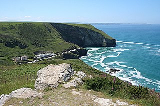
Trebarwith Strand is a section of coastline located near the coastal settlement of Trebarwith on the north coast of Cornwall, Britain, UK, 2+1⁄2 miles (4.0 km) south of Tintagel. It has 800m of sandy beach contained by cliffs in which natural caves are found. The beach can only be accessed at low tide. The strand was once used to land ships to export slate from the nearby quarries while sand from the beach was used for agricultural purposes. The view from the beach is dominated by rocks 300m offshore known as Gull Rock or Otterham Rocks.
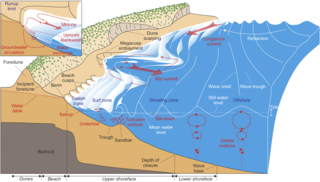
The surf zone or breaker zone is the nearshore part of a body of open water between the line at which the waves break and the shore. As ocean surface waves approach a shore, they interact with the bottom, get taller and steeper, and break, forming the foamy surface called surf. The region of breaking waves defines the surf zone. After breaking in the surf zone, the waves continue to move in, and they run up onto the sloping front of the beach, forming an uprush of water called swash. The water then runs back again as backwash. The water in the surf zone is relatively shallow, depending on the height and period of the waves.

Zuma Beach is a county beach at 30000 Pacific Coast Highway (PCH) in Malibu, California. One of the largest and most popular beaches in Los Angeles County, California, it is known for its long, wide sands and excellent surf. It consistently ranks among the healthiest beaches for clean water conditions in Los Angeles County.

A baïne is a pool of water of a few dozen to several hundred metres in length, parallel to the beach and directly connected to the sea. Each one is spaced every 300 to 400 metres and formed under the influence of waves and the tide. The French term baïne is typical for the Aquitaine coast of France in the departments of Gironde, Charente-Maritime and Landes, but it can occur on beaches throughout the world.

Praia do monte Clérigo is a beach within the municipality of Aljezur, in Algarve, Portugal. The beach is on the western Seaboard in the north west of the Algarve. The beach is 5.1 miles (8.2 km) north west of the village of Aljezur, and is 70.0 miles (112.7 km) north west, by road, from the regions capital of Faro. Praia do monte Clérigohas been designated a blue Flag beach (2012).
A rip current statement is a warning statement issued by the National Weather Service of the United States when there is a high threat of rip currents due to weather and ocean conditions.

Digging, also referred to as excavation, is the process of using some implement such as claws, hands, manual tools or heavy equipment, to remove material from a solid surface, usually soil, sand or rock on the surface of Earth. Digging is actually the combination of two processes, the first being the breaking or cutting of the surface, and the second being the removal and relocation of the material found there. In a simple digging situation, this may be accomplished in a single motion, with the digging implement being used to break the surface and immediately fling the material away from the hole or other structure being dug.

The Robberg Nature Reserve and Marine Protected Area is an inshore conservation region in the territorial waters of South Africa, near Plettenberg Bay in the Western Cape province.
The Browns Bank Complex Marine Protected Area is an offshore conservation region in the exclusive economic zone of South Africa
The Namaqua National Park Marine Protected Area is an inshore conservation region in Namaqualand at the Northern Cape province along the territorial waters of South Africa. It is closely associated with the Namaqua National Park, with which it has a common border and management.
The Marcus Island Marine Protected Area is a inshore conservation region in the territorial waters of South Africa.
Tomahawk Beach is a beach on the Pacific Ocean 7.5 kilometres (4.7 mi) southeast of the city centre of Dunedin, New Zealand. Located within the Ocean Grove Reserve between St Kilda Beach and Smaills Beach, at the point where Otago Peninsula joins the mainland of the South Island, Tomahawk Beach is a white sand beach popular with casual beach-goers and dog-walkers as well as surfers. Sand is extracted from the Tomahawk Lagoon channel, which runs across the beach, for commercial purposes and to prevent flooding.


