Demographics
Hikuai statistical area covers an area of the east coast of the Coromandel Peninsula which surrounds but does not include Tairua and Pauanui. It has an area of 284.16 km2 (109.71 sq mi) [1] and had an estimated population of 300 as of June 2022, [2] with a population density of 1 people per km2.
Historical population| Year | Pop. | ±% p.a. |
|---|
| 2006 | 231 | — |
|---|
| 2013 | 219 | −0.76% |
|---|
| 2018 | 237 | +1.59% |
|---|
| Source: [3] |
Hikuai statistical area had a population of 237 at the 2018 New Zealand census, an increase of 18 people (8.2%) since the 2013 census, and an increase of 6 people (2.6%) since the 2006 census. There were 84 households, comprising 117 males and 120 females, giving a sex ratio of 0.97 males per female. The median age was 47.0 years (compared with 37.4 years nationally), with 42 people (17.7%) aged under 15 years, 33 (13.9%) aged 15 to 29, 114 (48.1%) aged 30 to 64, and 42 (17.7%) aged 65 or older.
Ethnicities were 94.9% European/Pākehā, 19.0% Māori, 3.8% Pacific peoples, and 2.5% other ethnicities. People may identify with more than one ethnicity.
The percentage of people born overseas was 11.4, compared with 27.1% nationally.
Although some people chose not to answer the census's question about religious affiliation, 60.8% had no religion, 25.3% were Christian and 2.5% had other religions.
Of those at least 15 years old, 30 (15.4%) people had a bachelor's or higher degree, and 45 (23.1%) people had no formal qualifications. The median income was $29,000, compared with $31,800 nationally. 21 people (10.8%) earned over $70,000 compared to 17.2% nationally. The employment status of those at least 15 was that 102 (52.3%) people were employed full-time, 27 (13.8%) were part-time, and 3 (1.5%) were unemployed. [3]

Coromandel, also called Coromandel Town to distinguish it from the wider district, is a town on the Coromandel Harbour, on the western side of the Coromandel Peninsula, which is in the North Island of New Zealand. It is 75 kilometres east of the city of Auckland, although the road between them, which winds around the Firth of Thames and Hauraki Gulf coasts, is 190 km long. The population was 1,960 as of June 2022.

The Thames-Coromandel District is a territorial authority district in the North Island of New Zealand, covering all the Coromandel Peninsula and extending south to Hikutaia.

Hauraki District is a territorial authority within the Hauraki region of New Zealand. The seat of the council is at Paeroa.

Colville, a small town in the north of the Coromandel Peninsula in the North Island of New Zealand, lies 26 kilometres north of Coromandel in Colville Bay on the Hauraki Gulf, and is the northernmost town of any note on the peninsula. North of Colville, 28 kilometres of rough road lead to the small settlement of Port Jackson, close to the peninsula's northwesternmost point, Cape Colville and 20 km to Port Charles on the northeastern side.
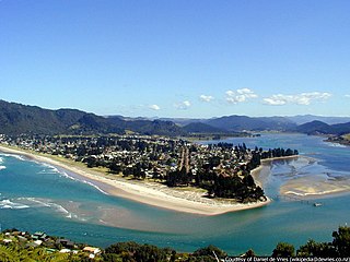
The town of Pauanui is on the east coast of the Coromandel Peninsula in the North Island of New Zealand. It lies at the mouth of the Tairua River on its south bank, directly opposite the larger town of Tairua.

The town of Tairua is on the east coast of the Coromandel Peninsula in the North Island of New Zealand. It lies at the mouth of the Tairua River on its north bank and on the small Paku Peninsula. Tairua is a Māori name which translates literally as tai: tides, rua: two.

Ngatea is a small town on the Hauraki Plains in the North Island of New Zealand. It is located 18 kilometres southwest of Thames and 70 kilometres southeast of Auckland. Ngatea lies on the Piako River, eight kilometres south of its outflow into the Firth of Thames.

Coroglen is a locality in the Coromandel Peninsula, New Zealand. It lies on State Highway 25, 18 kilometres south of Whitianga and 26 kilometres north west of Tairua. The "Tapu-Coroglen Road", a windy gravel road, connects it across the Coromandel Range with Tapu on the west coast of the peninsula.
Kennedy Bay is a locality in the north eastern Coromandel Peninsula of New Zealand. The Harataunga and Omoho Streams flow from the Coromandel Range past the settlement and into the bay to the east.

Te Puru is a locality on the western side of the Coromandel Peninsula of New Zealand. State Highway 25 runs through it. Tapu lies about 7 km to the north, and Thames is about 12 km to the south. The Te Puru Stream and about 18 tributaries drain a steep hilly 23 km2 area of the Coromandel Range, almost entirely covered by native forest. It runs through the settlement and into the Firth of Thames to the west. Flooding has been a problem.
Te Rerenga is a locality on the Whangapoua Harbour, Coromandel Peninsula, New Zealand. State Highway 25 runs through it. Coromandel is 12 km to the west. Whitianga lies to the south east. The Waitekuri and Opitonui Rivers flow from the Coromandel Range in the west and south through the area to drain in the Whangapoua Harbour.

Whenuakite is a locality on the Coromandel Peninsula of New Zealand. State Highway 25 runs through it. Whitianga is north west, Coroglen 8 km west, Cooks Beach and Hahei north, Hot Water Beach north east, and Tairua 18 km to the south east. The Whenuakite River flows from coastal hills in the east through the area to drain in the Whitianga Harbour.

The settlement of Broad Bay is located on the Otago Harbour coast of Otago Peninsula, in the South Island of New Zealand. It is administered as part of the city of Dunedin, and is technically a suburb of that city, though its isolation and semi-rural nature make it appear as a settlement in its own right.
Whangapoua is a small settlement of mostly holiday houses located on the Coromandel Peninsula of New Zealand. It is situated 25 minutes drive east over the Coromandel Range from Coromandel along the northeastern coastline encompassing popular white sand beaches New Chums Beach, Matarangi, Kuaotunu Beach and Otama Beach.
Tai Tapu, previously known as Taitapu, is a small town adjacent to the Halswell River and nestled in the Port Hills, located 6 km east of the town of Lincoln and 18 km south west of Christchurch in the Canterbury region of New Zealand's South Island. State Highway 75 passes through the centre of the village, connecting Christchurch with Akaroa and the Banks Peninsula.
State Highway 25 is a New Zealand state highway that runs eastwards across the Hauraki Plains then northwards up the western side of Coromandel Peninsula and down the eastern side to Waihi. The route is very scenic and provides access to idyllic beach holiday locations. It is a major road for holidaymakers and tourists, with the summer period around Christmas and New Year's Eve a particularly busy time. It is single carriageway for the entire route. The road is windy in many parts and prone to accidents. It is New Zealand's third longest two-digit state highway, after SH 35 and SH 94. It is part of the Pacific Coast Highway. There is one spur road, SH 25A, which cuts across the peninsula west to east, almost intersecting SH 25 at both ends.

Kopu is a settlement in on the Coromandel Peninsula in New Zealand's North Island. It is located near Thames, in the Thames-Coromandel District in the Waikato region.

Cooks Beach (Pukaki) is a town on a three-kilometre white-sand beach on the Coromandel Peninsula of New Zealand. To its north is Cooks Bay, and beyond that is Mercury Bay. To the east is the locality of Hahei and the tourist attraction of Cathedral Cove. Roads to the south connect to SH 25. On the northwest, Shakespeare Cliff is a scenic reserve with a lookout point.

Kauaeranga Valley is a valley created by the Kauaeranga River, which flows from the Coromandel Range southwest to the Firth of Thames at Thames, New Zealand in the North Island. It contains the settlement of Kauaeranga on the Coromandel Peninsula. It is located near Thames, in the Thames-Coromandel District in the Waikato region. It covers a land area of 180.51 km2.

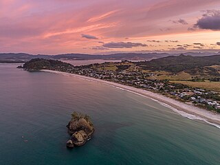
Onemana is a 1970s beach village on the eastern side of the Coromandel Peninsula of New Zealand, with a beach, a surf club, fire station and dairy. It lies 3 km (1.9 mi) to the east of State Highway 25, south of Pauanui and north of Whangamatā. The Wharekawa River and Opoutere are just to the north and west.

