
Trolling is a method of fishing where one or more fishing lines, baited with lures or bait fish, are drawn through the water at a consistent, low speed. This may be behind a moving boat, or by slowly winding the line in when fishing from a static position, or even sweeping the line from side-to-side, e.g. when fishing from a jetty. Trolling is used to catch pelagic fish such as salmon, mackerel and kingfish.

Big-game fishing, also known as offshore sportfishing, offshore gamefishing or blue-water fishing, is a form of recreational fishing targeting large game fish, usually on a large body of water such as a sea or ocean.

Recreational fishing, also called sport fishing or game fishing, is fishing for leisure, exercise or competition. It can be contrasted with commercial fishing, which is professional fishing for profit; or subsistence fishing, which is fishing for survival and livelihood.

A fishing lure is any one of a broad category of artificial angling baits that are inedible replicas designed to mimic prey animals that attract the attention of predatory fish, typically via appearances, flashy colors, bright reflections, movements, vibrations and/or loud noises which appeal to the fish's predation instinct and entice it into gulping the lure. Angling activities using lures are known as lure fishing.
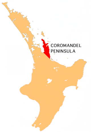
The Coromandel Peninsula on the North Island of New Zealand extends 85 kilometres (53 mi) north from the western end of the Bay of Plenty, forming a natural barrier protecting the Hauraki Gulf and the Firth of Thames in the west from the Pacific Ocean to the east. It is 40 kilometres (25 mi) wide at its broadest point. Almost its entire population lives on the narrow coastal strips fronting the Hauraki Gulf and the Bay of Plenty. In clear weather the peninsula is clearly visible from Auckland, the country's biggest city, which lies on the far shore of the Hauraki Gulf, 55 kilometres (34 mi) to the west. The peninsula is part of the Thames-Coromandel District and the Waikato Region.
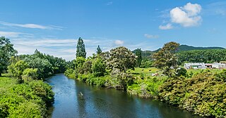
Hikuai is a small community on the Tairua River near the base of the Coromandel Peninsula in the North Island of New Zealand. It lies 40 kilometres north of Waihi and 10 kilometres southwest of Tairua, close to the junction of State Highways 25 and 25A, the latter of which is a winding road cutting across the steep Coromandel Range of hills. It is a tourist hot spot at times such as New Zealand Labour Day weekend, the Christmas and New Year holiday, and especially when Tairua and Pauanui are busy.
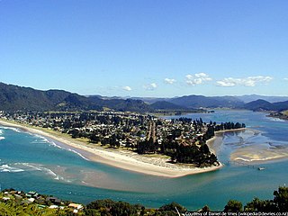
The town of Pauanui is on the east coast of the Coromandel Peninsula in the North Island of New Zealand. It lies at the mouth of the Tairua River on its south bank, directly opposite the larger town of Tairua.

Tairua is a beachside town located on the east coast of the Coromandel Peninsula in the North Island of New Zealand in the Thames-Coromandel District. It is located 150 kilometres east of Auckland and 125 kilometers north of Tauranga. It lies at the mouth of the Tairua River on its north bank and on the small Paku Peninsula. As the 2023 census, the town had a permanent population of 1,630. Tairua is a Māori name which translates literally as tai: tides, rua: two.

Slipper Island is located 3 kilometres (1.9 mi) to the east of the Coromandel Peninsula in New Zealand's North Island and 8 kilometres (5 mi) southeast of the town of Pauanui.

Sea trout is the common name usually applied to anadromous (sea-run) forms of brown trout, and is often referred to as Salmo trutta morpha trutta. Other names for anadromous brown trout are bull trout, sewin (Wales), peel or peal, mort, finnock (Scotland), white trout (Ireland), Dollaghan and salmon trout (culinary).
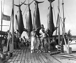
Marlin fishing or billfishing is offshore saltwater game fishing targeting several species of fast-swimming pelagic predatory fish with elongated rostrum collectively known as billfish, which include those from the families Istiophoridae and Xiphiidae (swordfish). It is considered by some fishermen to be a pinnacle of big-game fishing, due to the size, speed and power of the billfish and their relative elusiveness.

Coarse fishing is a phrase commonly used in Britain and Ireland. It refers to the angling for rough fish, which are fish species considered undesirable as food or game fish. Freshwater game fish are all salmonids, particularly salmon, trout and char. Generally, coarse fish are freshwater fish that are not salmonids, though there is often disagreement over whether grayling should be classified as a game fish or a coarse fish.

An artificial fly or fly lure is a type of fishing lure, usually used in the sport of fly fishing. In general, artificial flies are an imitation of aquatic insects that are natural food of the target fish species the fly fishers try to catch. Artificial flies are constructed by fly tying, in which furs, feathers, thread or any of very many other materials are tied onto a fish hook.

Spin fishing is an angling technique where a spinnerbait, a type of hybrid fishing lure with at least one freely rotating blade, is used to entice the fish to bite. When the line is reeled back, the spinnerbait blades will spin passively with the oncoming water flow, in turn stirring up a significant amount of turbulence and noise, which transmit through the water and provoke predatory fish to strike the lure out of their foraging as well as territorial instincts. Spin fishing is used in both freshwater and marine environments.
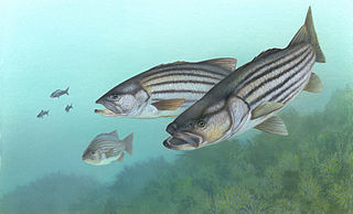
Striped bass are perciform fish found all along the Atlantic coast, from Florida to Nova Scotia. A distinct strain has historically existed in the Gulf of Mexico, but the fishery that exists there today is for stocked or reservoir-escapee fish. Striped bass are of significant value as sporting fish, and have been introduced to many areas outside their native range.
The following outline is provided as an overview of and topical guide to fishing:

Shad is a type of fish, much valued as a sport fish. The male shad is an excellent game fish, showing multiple jumps and an occasional end-over-end; it has been called a "freshwater tarpon". The gravid female does not fight much, but is often kept for the roe. The current world record is listed by the IGFA as 11 pounds 4 ounces (5.1 kg), set at Holyoke Dam, Massachusetts, on 19 May 1986 by Robert A. Thibodo.

Mahi-mahi are swift and acrobatic game fish with striking colours. These colours darken when the fish dies The current IGFA all tackle record is 39.91 kilograms (88lb), caught in 1998 in Exuma, Bahamas by Chris Johnson of Lake Mary, Florida. Catches average 7 to 13 kilograms, and any mahi-mahi over 18 kilograms (40 lb) is exceptional. Males are often larger than females.
Whangapoua Harbour is a shallow natural harbour in the northeast of the Coromandel Peninsula. It is located between Whangapoua in the north, Te Rerenga in the southwest, and Matarangi on the Omara Spit in the north separating it from the ocean. Two boat ramps and a jetty provide boat access into the harbour.
State Highway 25 is a New Zealand state highway that runs eastwards across the Hauraki Plains then northwards up the western side of Coromandel Peninsula and down the eastern side to Waihi. The route is very scenic and provides access to idyllic beach holiday locations. It is a major road for holidaymakers and tourists, with the summer period around Christmas and New Year's Eve a particularly busy time. It is single carriageway for the entire route. The road is windy in many parts and prone to accidents. It is New Zealand's third longest two-digit state highway, after SH 35 and SH 94. It is part of the Pacific Coast Highway. There is one spur road, SH 25A, which cuts across the peninsula west to east, almost intersecting SH 25 at both ends.
