
Coromandel, also called Coromandel Town to distinguish it from the wider district, is a town on the Coromandel Harbour, on the western side of the Coromandel Peninsula, which is in the North Island of New Zealand. It is 75 kilometres east of the city of Auckland, although the road between them, which winds around the Firth of Thames and Hauraki Gulf coasts, is 190 km long. The population was 1,930 as of June 2023.

The Thames-Coromandel District is a territorial authority district in the North Island of New Zealand, covering all the Coromandel Peninsula and extending south to Hikutaia.
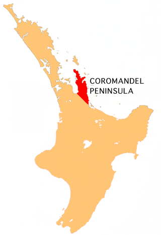
The Coromandel Peninsula on the North Island of New Zealand extends 85 kilometres (53 mi) north from the western end of the Bay of Plenty, forming a natural barrier protecting the Hauraki Gulf and the Firth of Thames in the west from the Pacific Ocean to the east. It is 40 kilometres (25 mi) wide at its broadest point. Almost its entire population lives on the narrow coastal strips fronting the Hauraki Gulf and the Bay of Plenty. In clear weather the peninsula is clearly visible from Auckland, the country's biggest city, which lies on the far shore of the Hauraki Gulf, 55 kilometres (34 mi) to the west. The peninsula is part of the Thames-Coromandel District and the Waikato Region.

Ōhope, is a beach settlement situated on the northeast coast of New Zealand's North Island in the Eastern Bay of Plenty. It is six kilometres east of Whakatāne and is located between Ōhiwa Harbour to the south and Ōhope Beach to the north, providing views of both.
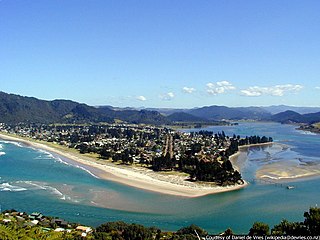
The town of Pauanui is on the east coast of the Coromandel Peninsula in the North Island of New Zealand. It lies at the mouth of the Tairua River on its south bank, directly opposite the larger town of Tairua.
Whitianga is a town on the Coromandel Peninsula, in the Waikato region of New Zealand's North Island. The town is located on Mercury Bay, on the northeastern coast of the peninsula. The town has a permanent population of 6,440 as of June 2023, making it the second-largest town on the Coromandel Peninsula behind Thames.

The town of Whangamatā is on the southeast coast of the Coromandel Peninsula in the North Island of New Zealand. It is located 30 kilometres north of Waihi, to the north of the western extremity of the Bay of Plenty.

Whiritoa is a small beach town on the Coromandel Peninsula, New Zealand between Whangamatā and Waihi Beach. It has a permanent population in the low hundreds, which swells to over a thousand during the New Year holiday period.

Hahei is a small settlement in Mercury Bay on the eastern side of the Coromandel Peninsula in New Zealand. It is near Cathedral Cove, between the settlements of Cooks Beach and Hot Water Beach. It is approximately 11 km south east of Whitianga and 8 km north of Hot Water Beach.

Ōmaha is a small beach town on Ōmaha Bay in the Auckland Region, in the north of New Zealand. It is located 74.7 km north of central Auckland. It is on a sandspit that adjoins Tāwharanui Peninsula and separates Whangateau Harbour from Ōmaha Bay. The nearest sizeable town is Warkworth which is situated 16.8 km south west of Ōmaha.

Tata Beach is a beach and small coastal settlement of predominantly holiday houses in the South Island, New Zealand. Found in the Golden Bay region, it is approximately 20 kilometres (12 mi) north-east of Tākaka.

Tapu is a locality on the western side of the Coromandel Peninsula of New Zealand. State Highway 25 runs through it. Coromandel is 35 km to the north, and Thames is 19 km to the south. The Tapu River flows from the Coromandel Range past the settlement and into the Firth of Thames to the west.

Mārahau is a village in the Tasman District of the South Island of New Zealand, approximately 19 kilometres (12 mi) north of Motueka. Its location on Tasman Bay and at the southern entrance of the Abel Tasman National Park makes it a popular holiday destination for those keen on outdoor activities. People access the Abel Tasman from Mārahau by tramping, kayaking and water taxi. In Mārahau itself, the beach offers sheltered and safe swimming, and horse trekking is popular throughout the busy summer season.
Whangapoua is a small settlement of mostly holiday houses located on the Coromandel Peninsula of New Zealand. It is situated 25 minutes drive east over the Coromandel Range from Coromandel along the northeastern coastline encompassing popular white sand beaches New Chums Beach, Matarangi, Kuaotunu Beach and Otama Beach.
Himatangi Beach is a small coastal community in the Manawatū-Whanganui region of New Zealand's North Island. It is located 32 kilometres west of Palmerston North in the centre of the largest sand dune geographical feature in New Zealand.

Waikuku Beach is a small settlement on the coast of the Canterbury region of New Zealand, about 3 km (1.9 mi) east of the settlement of Waikuku.
Kūaotunu is a small coastal township at the east coast of the Coromandel Peninsula on the mouth of the Kuaotunu River on the North Island of New Zealand.

Onemana is a 1970s beach village on the eastern side of the Coromandel Peninsula of New Zealand, with a beach, a surf club, fire station and dairy. It lies 3 km (1.9 mi) to the east of State Highway 25, south of Pauanui and north of Whangamatā. The Wharekawa River and Opoutere are just to the north and west.

Medlands Beach is in Oruawharo Bay on the east coast of Great Barrier Island in the Auckland Region of New Zealand. Auckland Council describes it as the most accessible beach on the island. It is one of the island's main tourist areas but is little developed. The small settlement of Medlands consists of permanent houses and holiday baches, some behind the dunes, sheltered from winds from the sea, and others elevated for a view.
Rings Beach is a beach settlement on the Coromandel Peninsula of New Zealand, between Matarangi on the west and Kūaotunu on the east. The eastern end of the settlement is known as Kūaotunu West.

