Matatoki

Last updated

Matatoki
Matatoki Cheese Barn.jpg
Lunch at the Matatoki Cheese Barn
Matatoki
Coordinates: 37°12′28″S175°36′24″E / 37.20778°S 175.60667°E / -37.20778; 175.60667
Country New Zealand
Region Waikato
District Thames-Coromandel District
WardThames ward
Community BoardThames Community
Electorates
Government
  Council Thames-Coromandel District Council

Matatoki is a locality on the Hauraki Plains of New Zealand. It lies on State Highway 26, south east of Thames and north of Paeroa. The Matatoki Stream runs from the Coromandel Range through the area to join the Waihou River. [1] [2]

Contents

The Kopu sawmill, a few kilometres north of Matatoki, closed at the end of June 2008, with the loss of 145 jobs. [3]

History

The eastern bank of the Waihou River near Matatoki was the location for many Hauraki Māori , such as Oruarangi pā and Paterangi pā, which were likely first settled in the 1300s. [4] Between the 1930s and 1960s, Oruarangi pā was an important archaeological site for Classic period Māori artifacts. [4]

Demographics

Matatoki-Puriri statistical area covers 161.07 km2 (62.19 sq mi) [5] and had an estimated population of 1,190 as of June 2023, [6] with a population density of 7 people per km2.

Historical population
YearPop.±% p.a.
20061,062    
20131,002−0.83%
20181,059+1.11%
Source: [7]

Matatoki-Puriri had a population of 1,059 at the 2018 New Zealand census, an increase of 57 people (5.7%) since the 2013 census, and a decrease of 3 people (−0.3%) since the 2006 census. There were 396 households, comprising 540 males and 519 females, giving a sex ratio of 1.04 males per female. The median age was 45.5 years (compared with 37.4 years nationally), with 204 people (19.3%) aged under 15 years, 165 (15.6%) aged 15 to 29, 507 (47.9%) aged 30 to 64, and 180 (17.0%) aged 65 or older.

Ethnicities were 93.2% European/Pākehā, 17.0% Māori, 1.4% Pacific peoples, 0.6% Asian, and 0.8% other ethnicities. People may identify with more than one ethnicity.

The percentage of people born overseas was 8.5, compared with 27.1% nationally.

Although some people chose not to answer the census's question about religious affiliation, 59.5% had no religion, 28.0% were Christian, 0.6% had Māori religious beliefs, 0.3% were Hindu and 0.8% had other religions.

Of those at least 15 years old, 90 (10.5%) people had a bachelor's or higher degree, and 234 (27.4%) people had no formal qualifications. The median income was $32,800, compared with $31,800 nationally. 108 people (12.6%) earned over $70,000 compared to 17.2% nationally. The employment status of those at least 15 years old was that 477 (55.8%) people were employed full-time, 153 (17.9%) were part-time, and 15 (1.8%) were unemployed. [7]

Education

Matatoki School is a coeducational full primary school (years 1–8) with a roll of 80 as of February 2024. [8] [9] The school opened in 1920. [10]

Railway station

Matatoki station site, now part of the Hauraki Rail Trail, in 2023 Matatoki railway station site.jpg
Matatoki station site, now part of the Hauraki Rail Trail, in 2023

Matatoki had a railway station, just south of the village ( 37°12′33″S175°36′11″E / 37.20917°S 175.60306°E / -37.20917; 175.60306 ), [11] from 1898 to 1995 on the Thames Branch. Larkins and O'Brien built the Kopu to Hikutaia section from August 1885 for £10,879, [12] had made good progress by January 1886 [13] and completed that section through Matatoki in May 1887. [14] Heath and Irwin started building the Hikutaia to Paeroa section, to the south, in January 1887. [15] [16] Work on the Paeroa to Te Aroha section began in 1892, [17] but in 1895 it was said, "a Parliamentary faction stopped the workers in their work". [18] Work on the bridges resumed in 1897. [19] The Minister of Public Works was able to travel by train from Hikutaia, through Matatoki, to Thames in July 1897. [20]

The Thames to Paeroa section of the line opened on Monday, 19 December 1898, with Matatoki as a flag station. It had a partly built 6th class station (a shelter shed), 100 ft (30 m) x 12 ft (3.7 m) platform and a loading bank. A year later there was also a passing loop for 35 wagons and a siding. By 1966 there was also a low-level loading bank for Matatoki Quarries to load crushed metal. [21]

Passenger trains were withdrawn on 28 March 1951 and freight on 22 February 1971, though Matatoki reopened for freight on 28 February 1974, closed again on 20 July 1980 and re-opened again on 30 November 1984, until June 28, 1991, the last day of commercial traffic on the Thames branch, which officially closed on March 29, 1995. [22] It is now used by the Hauraki Rail Trail. [23]

Preceding station Historical railways Following station
Puriri
Line closed, station closed
3.66 km (2.27 mi)
  Thames Branch
New Zealand Railways Department
  Kopu
Line closed, station closed
4.05 km (2.52 mi)

Related Research Articles

<span class="mw-page-title-main">Waikato</span> Region of New Zealand

Waikato is a region of the upper North Island of New Zealand. It covers the Waikato District, Waipa District, Matamata-Piako District, South Waikato District and Hamilton City, as well as Hauraki, Coromandel Peninsula, the northern King Country, much of the Taupō District, and parts of the Rotorua Lakes District. It is governed by the Waikato Regional Council.

<span class="mw-page-title-main">Morrinsville</span> Town in Waikato, New Zealand

Morrinsville is a provincial town in the Waikato region of New Zealand's North Island, with an estimated population of 8,960 as of June 2023. The town is located at the northern base of the Pakaroa Range, and on the south-western fringe of the Hauraki Plains. Morrinsville is around 33 kilometres east of Hamilton and 22 kilometres west of Te Aroha. The town is bordered by the Piako River to the east and the Waitakaruru Stream to the south.

Paeroa is a town in the Hauraki District of the Waikato Region in the North Island of New Zealand. Located at the base of the Coromandel Peninsula, it is close to the junction of the Waihou River and Ohinemuri River, and is approximately 20 kilometres south of the Firth of Thames.

<span class="mw-page-title-main">Te Aroha</span> Town in Waikato, New Zealand

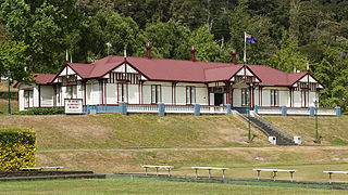
Te Aroha is a rural town in the Waikato region of New Zealand with a population of 3,906 people in the 2013 census, an increase of 138 people since 2006. It is 53 km (33 mi) northeast of Hamilton and 50 km (31 mi) south of Thames. It sits at the foot of 952 metres (3,123 ft) Mount Te Aroha, the highest point in the Kaimai Range.

<span class="mw-page-title-main">Thames-Coromandel District</span> Territorial authority district in Waikato, New Zealand

The Thames-Coromandel District is a territorial authority district in the North Island of New Zealand, covering all the Coromandel Peninsula and extending south to Hikutaia.

Thames is a town at the southwestern end of the Coromandel Peninsula in New Zealand's North Island. It is located on the Firth of Thames close to the mouth of the Waihou River. The town is the seat of the Thames-Coromandel District Council. The Māori iwi are Ngāti Maru, who are descendants of Marutuahu's son Te Ngako. Ngāti Maru is part of the Ngati Marutuahu confederation of tribes or better known as Hauraki Iwi.

<span class="mw-page-title-main">Waihou River</span> River in Waikato, New Zealand

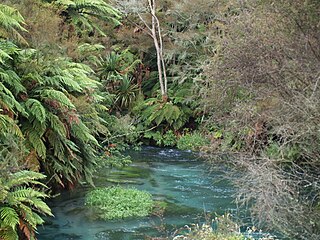
The Waihou River is located in the northern North Island of New Zealand. Its former name, Thames River, was bestowed by Captain James Cook in November 1769, when he explored 14 mi (23 km) of the river from the mouth. An older Māori name was "Wai Kahou Rounga". A 1947 Geographic Board enquiry ruled that the official name would be Waihou.

<span class="mw-page-title-main">Hauraki Plains</span> Region of New Zealand

The Hauraki Plains are a geographical feature and non-administrative area located in the northern North Island of New Zealand, at the lower (northern) end of the Thames Valley. They are located 75 kilometres south-east of Auckland, at the foot of the Coromandel Peninsula and occupy the southern portion of a rift valley bounded on the north-west by the Hunua Ranges, to the east by the Coromandel and Kaimai ranges and to the west by a series of undulating hills which separate the plains from the much larger plains of the Waikato River. Broadly, the northern and southern parts of the Hauraki Plains are administered by the Hauraki District and the Matamata-Piako District respectively.

<span class="mw-page-title-main">Putāruru</span> Town in Waikato, New Zealand

Putāruru is a small town in the South Waikato District and the Waikato region of New Zealand's North Island. It lies on the western side of the Mamaku Ranges and in the upper basin of the Waihou River. It is on the Oraka Stream 65 kilometres south-east of Hamilton. State Highway 1 and the Kinleith Branch railway run through the town.

<span class="mw-page-title-main">Hikutaia</span> Place in Waikato, New Zealand

Hikutaia is a locality on the Hauraki Plains of New Zealand. It lies on State Highway 26, south east of Thames and north of Paeroa. The Hikutaia River runs from the Coromandel Range through the area to join the Waihou River.

<span class="mw-page-title-main">Thames Branch</span>

The Thames Branch railway line connected Thames, New Zealand, with Hamilton and was originally part of the East Coast Main Trunk railway. Part of the line between Morrinsville and Waitoa remains open and is in use as the Waitoa Branch line, connecting to the Fonterra Dairy Factory at Waitoa.

<span class="mw-page-title-main">Hauraki Rail Trail</span> New Zealand rail trail

The Hauraki Rail Trail is one of the Great Rides of the New Zealand Cycle Trail system, using parts of the abandoned ECMT and Thames Branch railways in the Hauraki Gulf plains and the Coromandel Peninsula.

<span class="mw-page-title-main">Ohinemuri County</span>

Ohinemuri County was one of the counties of New Zealand of the North Island.

The Paeroa-Pokeno railway line or deviation in the upper North Island of New Zealand between Paeroa on the East Coast Main Trunk (ECMT) and Pokeno on the North Island Main Trunk (NIMT) was a proposed route with construction started but abandoned. The proposal has been revived in recent years as part of a more direct route between Auckland and Tauranga.

<span class="mw-page-title-main">Paeroa railway station</span> Defunct railway station in New Zealand

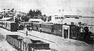
Paeroa railway station is a former railway station in Paeroa; on the Thames Branch, and on the East Coast Main Trunk Railway to Waihi. Between 1895 and 1991 Paeroa had a station at the north end of the town centre, followed by one further north, another back near the town centre and then another over a mile south of the town.

<span class="mw-page-title-main">Northern Steamship Company</span>

The Northern Steam Ship Company Ltd (NSS) served the northern half of the North Island of New Zealand from 1881 to 1974. Its headquarters, the Northern Steam Ship Company Building, remains in use on Quay St, Auckland as a bar.

Okauia is a rural settlement and community located east of Matamata, in the Waikato region of New Zealand's North Island.

Tirohia is a rural community in the Hauraki District and Waikato region of New Zealand's North Island. It was one of the main areas used by Ngāti Hako, including Te Rae o te Papa pā. A bridge was built over the Waihou River in 1919.

<span class="mw-page-title-main">Motumaoho</span> Village in Waikato, New Zealand

Motumaoho is a small village in the Waikato region of New Zealand's North Island, just to the west of the Pakaroa Range. It is on SH26, 25 km (16 mi) east of Hamilton and 7 km (4.3 mi) west of Morrinsville. The village is bordered by the Waitakaruru Stream to the east. Motumaoho can be translated as an intruding clump of trees.

Between 11 and 16 April 1981, the Waikato experienced flooding due to high levels of rain and wind. It mostly affected the Thames-Coromandel area and Paeroa. Over 2,250 evacuations took place. Insurance payouts cost $7,000,000. Over 200 homes were flooded.

References

  1. Peter Dowling, ed. (2004). Reed New Zealand Atlas. Reed Books. pp. map 15. ISBN   0-7900-0952-8.
  2. Roger Smith, GeographX (2005). The Geographic Atlas of New Zealand. Robbie Burton. pp. map 44. ISBN   1-877333-20-4.
  3. "Kopu mill to close, 145 jobs to be lost". The New Zealand Herald. 6 May 2008.
  4. 1 2 Prickett, Nigel (1990). "Archaeological Excavations at Raupa: the 1987 Season". Records of the Auckland Institute and Museum . 27: 73–153. ISSN   0067-0464. JSTOR   42906403. Wikidata   Q58677392.
  5. "ArcGIS Web Application". statsnz.maps.arcgis.com. Retrieved 23 December 2023.
  6. "Population estimate tables - NZ.Stat". Statistics New Zealand . Retrieved 25 October 2023.
  7. 1 2 "Statistical area 1 dataset for 2018 Census". Statistics New Zealand. March 2020. Matatoki-Puriri (168300). 2018 Census place summary: Matatoki-Puriri
  8. "New Zealand Schools Directory". New Zealand Ministry of Education. Retrieved 14 March 2024.
  9. Education Counts: Matatoki School
  10. "Matatoki School Centenary 1920 to 2020!". Matatoki School. 10 March 2020. Archived from the original on 3 October 2020.
  11. "1:63360 map Sheet: N49 Thames". www.mapspast.org.nz. 1953. Retrieved 15 March 2023.
  12. "WAIKATO-THAMES RAILWAY. Thames Star". paperspast.natlib.govt.nz. 4 August 1885. Retrieved 13 March 2023.
  13. "Thames Advertiser". paperspast.natlib.govt.nz. 18 January 1886. Retrieved 13 March 2023.
  14. "Te Aroha News". paperspast.natlib.govt.nz. 14 May 1887. Retrieved 13 March 2023.
  15. "LATEST TELEGRAMS. Te Aroha News". paperspast.natlib.govt.nz. 8 January 1887. Retrieved 13 March 2023.
  16. "Thames Advertiser". paperspast.natlib.govt.nz. 22 March 1887. Retrieved 13 March 2023.
  17. "Thames Star". paperspast.natlib.govt.nz. 12 May 1892. Retrieved 13 March 2023.
  18. "The Rambler. Thames Star". paperspast.natlib.govt.nz. 13 June 1895. Retrieved 13 March 2023.
  19. "Thames Advertiser". paperspast.natlib.govt.nz. 11 March 1897. Retrieved 13 March 2023.
  20. "HON. W. HALL-JONES. Ohinemuri Gazette". paperspast.natlib.govt.nz. 28 July 1897. Retrieved 14 March 2023.
  21. Scoble, Juliet. "Station Archive". Rail Heritage Trust of New Zealand.
  22. "Juliet Scoble: Names & Opening & Closing Dates of Railway Stations in New Zealand" (PDF). Archived from the original (PDF) on 24 January 2018. Retrieved 30 November 2015.
  23. "Section D: Paeroa to Te Aroha". haurakirailtrail.co.nz. Retrieved 11 March 2023.