
The North Island, also officially named Te Ika-a-Māui, is one of the two main islands of New Zealand, separated from the larger but much less populous South Island by the Cook Strait. The island's area is 113,729 square kilometres (43,911 sq mi), making it the world's 14th-largest island. It has a population of 3,925,800, accounting for approximately 77% of the total residents of New Zealand.

Coromandel, also called Coromandel Town to distinguish it from the wider district, is a town on the Coromandel Harbour, on the western side of the Coromandel Peninsula, which is in the North Island of New Zealand. It is 75 kilometres east of the city of Auckland, although the road between them, which winds around the Firth of Thames and Hauraki Gulf coasts, is 190 km long. The population was 1,890 as of June 2021.

The Thames-Coromandel District is a territorial authority district in the North Island of New Zealand, covering all the Coromandel Peninsula and extending south to Hikutaia.

Hauraki District is a territorial authority within the Hauraki region of New Zealand. The seat of the council is at Paeroa.
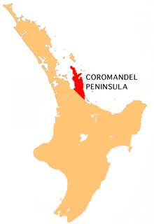
The Coromandel Peninsula on the North Island of New Zealand extends 85 kilometres (53 mi) north from the western end of the Bay of Plenty, forming a natural barrier protecting the Hauraki Gulf and the Firth of Thames in the west from the Pacific Ocean to the east. It is 40 kilometres (25 mi) wide at its broadest point. Almost its entire population lives on the narrow coastal strips fronting the Hauraki Gulf and the Bay of Plenty. In clear weather the peninsula is clearly visible from Auckland, the country's biggest city, which lies on the far shore of the Hauraki Gulf, 55 kilometres (34 mi) to the west. The peninsula is part of the Thames-Coromandel District of the Waikato region.

Cape Colville is the northernmost point of the Coromandel Peninsula in New Zealand's North Island. It lies 85 kilometres north of Thames, and 70 kilometres northeast of the city of Auckland, on the other side of the Hauraki Gulf. The small settlements of Port Jackson and Fletcher Bay lie immediately to the west and east respectively of the cape.

Colville, a small town in the north of the Coromandel Peninsula in the North Island of New Zealand, lies 26 kilometres north of Coromandel in Colville Bay on the Hauraki Gulf, and is the northernmost town of any note on the peninsula. North of Colville, 28 kilometres of rough road lead to the small settlement of Port Jackson, close to the peninsula's northwesternmost point, Cape Colville and 20 km to Port Charles on the northeastern side.
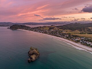
Whitianga is a town on the Coromandel Peninsula, in the Waikato region of New Zealand's North Island. The town is located on Mercury Bay, on the northeastern coast of the peninsula. The town has a permanent population of 6,330 as of June 2021, making it the second-largest town on the Coromandel Peninsula behind Thames.
The Moehau Range is the northernmost range on the Coromandel Peninsula, extending from the settlement of Colville northwards to the tip of the peninsula. Mount Moehau is the highest point of the range, at 892m above sea level.

Coroglen is a locality in the Coromandel Peninsula, New Zealand. It lies on State Highway 25, 18 kilometres south of Whitianga and 26 kilometres north west of Tairua. The "Tapu-Coroglen Road", a windy gravel road, connects it across the Coromandel Range with Tapu on the west coast of the peninsula.
Manaia is a locality on the western side of the Coromandel Peninsula of New Zealand. It lies to the east of State Highway 25, south of Coromandel and north of Tapu. The Manaia River flows from the Coromandel Range through the area and into the Manaia Harbour to the west. The harbour contains mussel farms.
Tapu is a locality on the western side of the Coromandel Peninsula of New Zealand. State Highway 25 runs through it. Coromandel is 35 km to the north, and Thames is 19 km to the south. The Tapu River flows from the Coromandel Range past the settlement and into the Firth of Thames to the west.
Kennedy Bay is a locality in the north eastern Coromandel Peninsula of New Zealand. The Harataunga and Omoho Streams flow from the Coromandel Range past the settlement and into the bay to the east.

Te Puru is a locality on the western side of the Coromandel Peninsula of New Zealand. State Highway 25 runs through it. Tapu lies about 7 km to the north, and Thames is about 12 km to the south. The Te Puru Stream and about 18 tributaries drain a steep hilly 23 km² area of the Coromandel Range, almost entirely covered by native forest. It runs through the settlement and into the Firth of Thames to the west. Flooding has been a problem.
Te Rerenga is a locality on the Whangapoua Harbour, Coromandel Peninsula, New Zealand. State Highway 25 runs through it. Coromandel is 12 km to the west. Whitianga lies to the south east. The Waitekuri and Opitonui Rivers flow from the Coromandel Range in the west and south through the area to drain in the Whangapoua Harbour.
The Manaia River is a river of the Coromandel Peninsula in New Zealand's North Island. It flows north from its sources in the Coromandel Range, reaching the waters of the Hauraki Gulf at Manaia Harbour, 10 kilometres (6 mi) southwest of Coromandel.
The Te Mata River is a river of the Coromandel Peninsula in New Zealand's North Island. It flows west to reach the Firth of Thames at the small settlement of Te Mata, 25 kilometres (16 mi) south of Coromandel.
Whangapoua is a small settlement of mostly holiday houses on the Coromandel Peninsula of New Zealand. It is situated 25 minutes drive east over the Coromandel Range from Coromandel along the northeastern coastline encompassing popular white sand beaches New Chums Beach, Matarangi, Kuaotunu Beach and Otama Beach.
Whangapoua Harbour is a shallow natural harbour in the northeast of the Coromandel Peninsula. It is located between Whangapoua in the north, Te Rerenga in the southwest, and Matarangi on the Omara Spit in the north separating it from the ocean. Two boat ramps and a jetty provide boat access into the harbour.
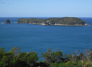
Mahurangi Island, also known as Goat Island, is located 1.1 kilometres (0.68 mi) to the north-east of Hahei on the Coromandel Peninsula in New Zealand's North Island. The uninhabited island is 6 hectares in size.
