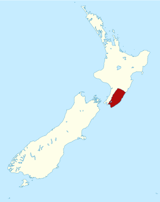
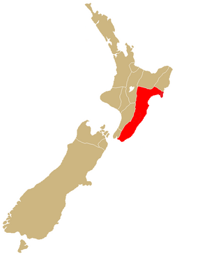
Hawke's Bay is a region on the east coast of New Zealand's North Island. The region is named for Hawke Bay, which was named in honour of Edward Hawke. The region's main centres are the cities of Napier and Hastings, while the more rural parts of the region are served by the towns of Waipukurau, Waipawa, and Wairoa.
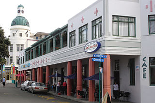
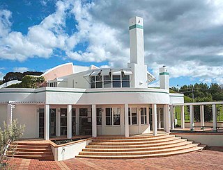
Napier is a city on the eastern coast of the North Island of New Zealand and the seat of the Hawke's Bay region. It is a beachside city with a seaport, known for its sunny climate, esplanade lined with Norfolk pines, and extensive Art Deco architecture. For these attributes, Napier is sometimes romantically referred to as the "Nice of the Pacific".

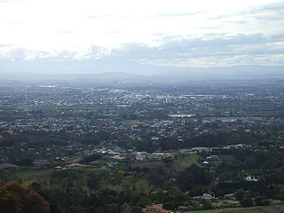
Hastings is an inland city of New Zealand and is one of the two major urban areas in Hawke's Bay, on the east coast of the North Island. The population of Hastings is 51,500, with a further 15,200 people in Havelock North and 2,090 in Clive. Hastings is about 18 kilometres inland of the coastal city of Napier. These two neighbouring cities are often called "The Bay Cities" or "The Twin Cities".
The Wairarapa, a geographical region of New Zealand, lies in the south-eastern corner of the North Island, east of metropolitan Wellington and south-west of the Hawke's Bay Region. It is lightly populated, having several rural service towns, with Masterton being the largest. It is named after its largest lake, Lake Wairarapa.

Havelock North is a town in the Hawke's Bay region of the North Island of New Zealand, situated less than 2 km south-east of the city of Hastings. It was a borough for many years until the 1989 reorganisation of local government saw it merged into the new Hastings District, and it is now administered by the Hastings District Council.
Ngāti Kahungunu is a Māori iwi located along the eastern coast of the North Island of New Zealand. The iwi is traditionally centred in the Hawke's Bay and Wairārapa regions. The Kahungunu iwi also comprises 86 hapū (sub-tribes) and 90 marae.
Hastings District is a Territorial authority district within the Hawke's Bay Region, on the east coast of the North Island of New Zealand. It covers the southern half of the Hawke's Bay coast, excluding Napier City, which is a separate territorial authority. Hastings District Council is headquartered in the city of Hastings, the district's largest town.

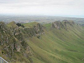
Cape Kidnappers, known in Māori as Te Kauwae-a-Māui and officially gazetted as Cape Kidnappers / Te Kauwae-a-Māui, is a headland at the southeastern extremity of Hawke's Bay on the east coast of New Zealand's North Island and sits at the end of an 8 kilometres (5.0 mi) peninsula which protrudes into the Pacific Ocean. It is 20 kilometres (12 mi) south-east of the city of Napier. Access to the cape by road stops at Clifton, which is the departure point for many tourists visiting the gannet colony. The Cape Kidnappers Golf Course lies between the headland and the nearby coastal community of Te Awanga.

The Tukituki River is in the Hawke's Bay region of the eastern North Island of New Zealand. It flows from the Ruahine Ranges to the Pacific Ocean at the southern end of Hawke Bay.

New Zealand wine is produced in several of its distinct winegrowing regions. As an island country in the South Pacific Ocean, New Zealand has a largely maritime climate, although its elongated geography produces considerable regional variation from north to south. Like many other New World wines, New Zealand wine is usually produced and labelled as single varietal wines, or if blended, winemakers list the varietal components on the label. New Zealand is best known for its Marlborough Sauvignon Blanc, and more recently its dense, concentrated Pinot Noir from Marlborough, Martinborough and Central Otago.
Putorino is a small farming settlement in northern Hawke's Bay, on the eastern side of New Zealand's North Island. It is located on State Highway 2 between Tutira and Mohaka, on the Hastings side of the border between Hastings and Wairoa.
Ngāti Te Whatuiāpiti, Ngāti Te Whatu-i-āpiti or Ngāi Te Whatuiāpiti is a Māori hapū of the Ngāti Kahungunu iwi in Hawke's Bay, New Zealand.
Te Mata Estate is an independent, family-owned Hawke's Bay winery and New Zealand's oldest, in continuous operation since 1895. The winery produces everything on-premises at their Havelock Hills site near Havelock North, 15 kilometres (9.3 mi) south of Napier. Established in the late 19th century by the Chambers family, the winery and original vineyards were the first to be heritage-protected, and is one of New Zealand's most highly regarded wineries.

The Hawke's Bay wine region is New Zealand's oldest and second-largest wine-production region, on the east coast of the North Island. Production reached 41,000 tonnes in 2018 from 4,681 hectares of planted vines, representing 10.2% of total national production. Some of the oldest wineries still operating in New Zealand, including Te Mata Estate, Church Road, and Mission Estate, were established in the Hawke's Bay area in the late 19th century. Despite this, it was only established as a geographical indication (GI) in 2018. The GI protects any wine produced within the boundaries of the entire Hawke's Bay Region, but in practice the vineyards are chiefly concentrated in the plains and low hills surrounding the cities of Napier and Hastings.
Waimiha is a rural community in the Ruapehu District and Manawatū-Whanganui region of New Zealand's North Island.
Elsthorpe is a village in the Central Hawke's Bay District and Hawke's Bay Region of New Zealand's North Island. It is located east of Ōtāne, Waipawa and State Highway 2 and west of the east coast.

Meeanee is a locality south of the city of Napier, in the Hawke's Bay Region on the east coast of New Zealand's North Island. It was named after the Battle of Meeanee in India, won by Sir Charles Napier, the city's namesake. Along with such locations as Clive and Havelock North, it is one of several places within Hawke's Bay to be named after events or people in Colonial India.
Mangateretere is a rural community in the Hastings District and Hawke's Bay Region of New Zealand's North Island. The area is northeast of Hastings city and southwest of Clive.

Kohinurākau or Kōhinerākau is a 490 m (1,610 ft) mountain in the Kohinurākau Range, 8.5 km (5.3 mi) south-southwest of Havelock North in the Hawke's Bay region of New Zealand. The mountain is the main television and FM radio transmitter site for Napier, Hastings and the wider Hawke's Bay region.
Rongokako was a Māori ariki (chieftain) and tohunga (priest) of the Tākitimu tribal confederation and ancestor of the Ngāti Kahungunu iwi, who is famous for his giant leaps. He is said to have lived at the end of the fourteenth century, about eighteen generations before the mid-twentieth century. Several places along the east coast of the North Island are traditionally connected to him.