In Māori mythology, taniwha are large supernatural beings that live in deep pools in rivers, dark caves, or in the sea, especially in places with dangerous currents or deceptive breakers . They may be considered highly respected kaitiaki of people and places, or in some traditions as dangerous, predatory beings, which for example would kidnap women to have as wives.

Hawke's Bay is a region on the east coast of New Zealand's North Island. The region is named for Hawke Bay, which was named in honour of Edward Hawke. The region's main centres are the cities of Napier and Hastings, while the more rural parts of the region are served by the towns of Waipukurau, Waipawa, and Wairoa.
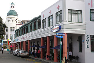
Napier is a city on the eastern coast of the North Island of New Zealand and the seat of the Hawke's Bay region. It is a beachside city with a seaport, known for its sunny climate, esplanade lined with Norfolk pines, and extensive Art Deco architecture. Napier is sometimes referred to as the "Nice of the Pacific", although that is largely outdated and a more common nickname is 'The Art Deco Capital of the world'.

Hastings is an inland city of New Zealand and is one of the two major urban areas in Hawke's Bay, on the east coast of the North Island. The population of Hastings is 51,500, with a further 15,200 people in Havelock North and 2,090 in Clive. Hastings is about 18 kilometres inland of the coastal city of Napier. These two neighbouring cities are often called "The Bay Cities" or "The Twin Cities".
The Heretaunga Plains is a 300 square kilometres (120 sq mi) alluvial plain at the southern end of Hawke Bay on the east coast of the North Island of New Zealand. The towns of Napier, Hastings and Havelock North are on the plain.

Lake Wakatipu is an inland lake in the South Island of New Zealand. It is in the southwest corner of the Otago region, near its boundary with Southland. Lake Wakatipu comes from the original Māori name Whakatipu wai-māori.

The Firth of Thames is a large bay located in the north of the North Island of New Zealand. It is the firth of the rivers Waihou and Piako, the former of which was formerly named the Thames River, and the town of Thames lies on its southeastern coast.
The Waiapu River is a river in the Gisborne District of the North Island of New Zealand, with a total length of approximately 130 kilometres (81 mi). Found in the north-east of the Waiapu Valley, it flows north-east from the joining of the Mata River and the Tapuaeroa River, then passes by Ruatoria before reaching the Pacific Ocean at Rangitukia. Other tributaries of the Waiapu River include the Mangaoporo, Poroporo, Wairoa, Maraehara rivers, and the Paoaruku stream. It is the most well-known river in the region and lies within the rohe (territory) of Ngāti Porou, the largest iwi on the East Coast, and second largest in New Zealand. The area was the site of hostilities during the New Zealand Wars from June to October in 1865, both between Pākehā and Māori, and between factions of Ngāti Porou.

Karamu High School is a co-educational state high school in Hastings, New Zealand for students in Years 9 to 13. The school is the main co-ed secondary school within Hastings City itself. The school’s campus is located to the easternmost end of Hastings City, adjacent to Windsor Park to the west and the Heretaunga Plains’ orchards to the east.

Ocean Beach is a long beach of golden sand in the Hastings District of the Hawke's Bay Region, on the east coast of New Zealand. It lies between Cape Kidnappers to the north, and Waimarama Beach to the south. Ocean Beach has a small population, mainly of Māori ethnicity. Local Māori know it also as Waipuka. Visitors, mainly Hawke's Bay locals, enjoy it as a seaside recreational beach. Ocean Beach has few roads – only the road to it from Havelock North, and some others branching off to a few houses.

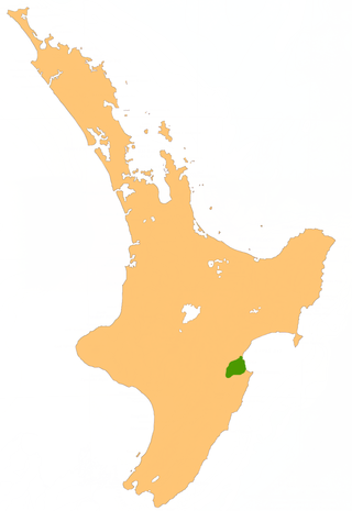
Tukituki is a New Zealand parliamentary electorate, returning one Member of Parliament to the New Zealand House of Representatives. Named after the Tukituki River which runs through the electorate, it was established for the 1996 general election and has existed since. The current MP for Tukituki is Catherine Wedd of the National Party, who won the seat from first-term Labour Party MP Anna Lorck.
The Waipawa River is a braided river of southern Hawke's Bay, in New Zealand's eastern North Island. It flows southeast from the slopes of 1,687 m (5,535 ft) Te Atuaoparapara in the Ruahine Range, past the town of Waipawa, before joining the Tukituki River. The river rises at the 1,326 m (4,350 ft) Waipawa Saddle, which is also the source of the Waikamaka River. The Mangaonuku Stream is a tributary on the northern bank, west of Waipawa, near Ruataniwha. The Waipawa's flow is generally greater than that of the Tukituki River, into which it flows.
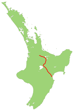
State Highway 5, one of New Zealand's eight national highways, runs from State Highway 1 at Tīrau, in the south Waikato, to State Highway 2, close to the Hawkes Bay coast at Bay View, 10 km north of Napier. It is the second shortest of the national highways.

State Highway 2 runs north–south through eastern parts of the North Island of New Zealand from the outskirts of Auckland to Wellington. It runs through Tauranga, Gisborne, Napier, Hastings and Masterton. It is the second-longest highway in the North Island, after State Highway 1, which runs the length of both of the country's main islands.
The Makaretu River is a river of the southern Hawke's Bay region of New Zealand's North Island. One of numerous roughly parallel rivers, it flows east from the slopes of the Ruahine Range north of Dannevirke, passing close to the township of Takapau before meeting the waters of the Tukituki River just to the west of Waipukurau.
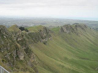
Te Mata Peak is a peak south of Hastings rising up to 399m in the Te Mata Hills in the Hawke's Bay region of New Zealand. A sealed road leads to the popular lookout at the summit, as well as many trails for hikers and mountain bikers. The Hastings suburb of Havelock North is situated at the base of the peak. Te Mata peak and the surrounding range runs in a North-East to South-West direction. The slopes on the North-Western side build up gradually. Havelock North is built upon the rolling hills at the lower extent of the ranges. The topography of the South-Eastern side has been heavily influenced by the Tukituki River, forming the Tukituki Valley. From Te Mata Peak, cliffs on the South-Eastern side drop 140 meters before extending into the rolling hills of the Tukituki Valley, making these cliffs some of the highest in the North Island of New Zealand. Their height is subject to erosion, with multiple instances of rockfall into the valley below. From the peak, large boulders can be witnessed in the valley as evidence of previous rockfall.

Waiapu Valley, also known as the Waiapu catchment, Waiapu River valley or simply Waiapu, is a valley in the north of the Gisborne Region on the East Coast of the North Island of New Zealand. It is the catchment area for the Waiapu River and its tributaries, and covers 1,734 square kilometres (670 sq mi). The Raukumara Range forms the western side of the valley, with Mount Hikurangi in the central west. The towns of Ruatoria and Tikitiki are in the north-east of the valley.

Lawrence Arden Yule is a New Zealand politician. He was Mayor of Hastings from 2001 to 2017, and a Member of Parliament representing the Tukituki electorate for the National Party from 2017 to 2020.

Anna Louise Lorck is a New Zealand politician of the Labour Party. She served in the New Zealand House of Representatives as the MP for Tukituki from 2020 to 2023.
Hatuma is 7 km (4.3 mi) south of Waipukurau, in Central Hawke's Bay in the east of the North Island of New Zealand. Meshblock 7016748, which covers 19.3 km2 (7.5 sq mi) from the edge of Waipukurau to Marakeke, had a population of 153 in 2018.

