New Zealand State Highway 67

Last updated

State Highway 67 NZ.svg

State Highway 67
Route information
Maintained by NZ Transport Agency
Major junctions
South end SH 6/Lower Buller Gorge Road State Highway 6 NZ.svg 6 km south of Westport, New Zealand
North end Regional Route 67 NZ.png De Malmanches Road at Mokihinui
Location
Primary
destinations
Westport, Waimangaroa, Granity, Hector/Ngakawau, Summerlea
Highway system
State Highway 65 NZ.svg SH 65 SH 69 State Highway 69 NZ.svg

State Highway 67 is a New Zealand state highway located in the northern parts of the South Island of New Zealand. It is 51.2 km long and connects State Highway 6 with the settlement of Mokihinui. It used to be 96 kilometres long and ran the entire length of the road to Karamea. The highway and its spur serves the large West Coast town of Westport and lies entirely within the Buller District.

The New Zealand state highway network is the major national highway network in New Zealand. Nearly 100 roads in the North and South Islands are state highways. All state highways are administered by the NZ Transport Agency.

South Island Southernmost of the two main islands in New Zealand

The South Island, also officially named Te Waipounamu, is the larger of the two major islands of New Zealand in surface area; the other being the smaller but more populous North Island. It is bordered to the north by Cook Strait, to the west by the Tasman Sea, and to the south and east by the Pacific Ocean. The South Island covers 150,437 square kilometres (58,084 sq mi), making it the world's 12th-largest island. It has a temperate climate.

New Zealand State Highway 6 road in New Zealand

State Highway 6 is a major New Zealand state highway. It extends from the northeastern corner of the South Island across the top of the island, then down the length of the island, initially along the West Coast and then across the Southern Alps through inland Otago and finally across the Southland Plains to the island's south coast. Distances are measured from north to south.

Contents

Route

SH 67 starts at SH 6 and proceeds in a northerly direction until the intersection with SH 67A. There the road turns right and crosses the Buller River to enter the township of Westport. Once in the CBD, the highway turns right and proceeds in an easterly direction until it crosses the Orowaiti River.

Buller River river of New Zealand

The Buller River is in the South Island of New Zealand. One of the country's longest rivers, it flows for 170 kilometres (110 mi) from Lake Rotoiti through the Buller Gorge and into the Tasman Sea near the town of Westport. As Rotoiti itself is fed by the Travers River it can be claimed that the Buller's source is at the headwaters of the Travers, on the northern slopes of Mount Travers in the Saint Arnaud Range. The Paparoa Range separates the Buller River from the Grey River. A number of flora and fauna are found in the Buller watershed, many of these extending onto the slopes of the Paparoa Range.

Westport, New Zealand Place in West Coast, New Zealand

Westport is a town in the West Coast region of the South Island of New Zealand. It is on the northern bank and at the mouth of the Buller River, close by the prominent headland of Cape Foulwind. It is connected via State Highway 6 with Greymouth, 100 kilometres (62 mi) to the south, and with Nelson 222 kilometres (138 mi) in the northeast, via the Buller Gorge.

The Orowaiti River is a river of the West Coast Region of New Zealand's South Island. The smaller of the two rivers which run through the town of Westport, it reaches the Karamea Bight three kilometres to the east of its larger neighbour, the Buller River.

The road passes through alternating areas of farmland and temperate rainforest vegetation as it passes the settlements of Waimangaroa (turn right here for Denniston), Granity (turn right here for Millerton, Stockton and Stockton Mine), Ngakwau and Hector. Before Hector the road crosses the Ngakawau River.

Waimangaroa Place in West Coast, New Zealand

Waimangaroa is a small town located on the West Coast of New Zealand.

Denniston, New Zealand Place in West Coast, New Zealand

Denniston is a small settlement, 15 kilometres east of Westport, on the West Coast of the South Island of New Zealand. It is situated on an exposed rocky plateau, 600 metres above sea level, in the Papahaua Ranges.

Granity Place in West Coast, New Zealand

Granity is a small town on the West Coast of New Zealand's South Island, 28 kilometres (17 mi) north-east of Westport on State Highway 67. Karamea is 68 kilometres (42 mi) further north.

Beyond Hector, the road acts as a frontier between the coastline and the adjoining hills until it reaches Waimarie and Summerlea, where it swings inland towards Mokihinui (turn here to Seddonville. After crossing the Mokihinui River, the highway number officially terminates here but the road continues on towards Karamea with the red shield superseded by white shields as Regional Route 67 ( Regional Route 67 NZ.png ).

Summerlea, New Zealand Place in West Coast, New Zealand

Summerlea is a lightly populated locality on the West Coast of New Zealand's South Island.

Seddonville Place in West Coast, New Zealand

Seddonville is a lightly populated locality on the West Coast of New Zealand's South Island. It is most famous for the historical role it played in New Zealand's coal mining industry.

Mokihinui River river in New Zealand

The Mokihinui River is a river located on the West Coast of New Zealand's South Island, about 40 kilometres north of Westport. Meridian Energy had proposed the Mokihinui Hydro project on the river in 2007 but it was cancelled in May 2012. In 2019, it was announced that large parts of the river catchment, including 15km of river bed, would be added to Kahurangi National Park.

Spur Sections

State Highway 67a NZ.svg

State Highway 67A
Location WestportCape Foulwind
Length 8.9 km (5.5 mi)
SH 67A terminating at the Holcim cement plant Cape Foulwind And Holcim Cement Westport.jpg
SH 67A terminating at the Holcim cement plant

State Highway 67A is a New Zealand state highway and a spur of SH 67. It is 8.9 km long and connects Westport with the settlements of Carters Beach and Cape Foulwind, as well as the Holcim cement plant which plays a significant part in the local economy.

Carters Beach Coastal settlement in New Zealand

Carters Beach is a small town on the West Coast of New Zealand's South Island, located 6 kilometres (4 mi) west of Westport on State Highway 67A. It is the only sheltered sandy beach on the West Coast suitable for swimming.

Cape Foulwind point in New Zealand

Cape Foulwind is a prominent headland on the West Coast of New Zealand's South Island, overlooking the Tasman Sea. It is located ten kilometres west of the town of Westport. It was previously named Rocky Cape by Abel Tasman, the first European to visit it, in 1642. The present name was bestowed upon this promontory by English explorer James Cook in 1770 after his ship Endeavour was blown quite a distance offshore from this point.

Holcim building materials and aggregates company

Holcim is a Swiss-based global building materials and aggregates company. Founded in 1912, the company expanded into France and then throughout Europe and Middle East during the 1920s. They expanded in the Americas during the 1950s and went public in 1958. The company continued to expand in Latin America and added Asian divisions during the 1970s and 1980s. A series of mergers and buyouts made Holcim one of the two largest cement manufacturers worldwide by 2014, roughly tied with rival Lafarge. In April 2014, the two companies agreed to a US$60 billion "merger of equals". The companies merged on 10 July 2015 to form LafargeHolcim as the new holding company.

See also

International Standard Book Number Unique numeric book identifier

The International Standard Book Number (ISBN) is a numeric commercial book identifier which is intended to be unique. Publishers purchase ISBNs from an affiliate of the International ISBN Agency.

Related Research Articles

Karamea Place in West Coast, New Zealand

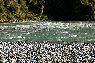
Karamea is a town on the West Coast of the South Island of New Zealand. It is the northernmost settlement of any real size on the West Coast, and is located 96 kilometres (60 mi) north-east by road from Westport. There is no other connecting road to the town - the road north ends at the Kohaihai River some 20 kilometres (12 mi) from Karamea, at the south western end of the Heaphy Track.

New Zealand State Highway 1 road in New Zealand

State Highway 1 is the longest and most significant road in the New Zealand road network, running the length of both main islands. It appears on road maps as SH 1 and on road signs as a white number 1 on a red shield, but it has the official designations SH 1N in the North Island, SH 1S in the South Island.

Millerton, New Zealand Place in West Coast, New Zealand

Millerton is a small settlement in the northwestern South Island of New Zealand in the West Coast region. It is in the Papahaua Ranges, around 25 kilometres north east of Westport, on SH67 from Westport to Karamea.

The Seddonville Branch, later truncated as the Ngakawau Branch, is a branch line railway in the West Coast region of New Zealand's South Island. Construction began in 1874 and it reached its terminus at the Mokihinui Mine just beyond Seddonville in 1895. In 1981 it was closed past Ngakawau and effectively became an extension of the Stillwater–Westport Line, since formalised as the Stillwater Ngakawau Line.

Hector and Ngakawau Place in West Coast, New Zealand

Hector and Ngakawau are two lightly populated settlements located at the mouth of the Ngakawau River in the West Coast region of New Zealand. Both settlements are situated on State Highway 67 between Westport and Karamea. The 2001 New Zealand census found that Hector and Ngakawau have a combined population of 300, a drop of 16% or 57 people since the 1996 census. This has dropped further in 2006 to 234 people. Despite a low population, many of the workers at New Zealand's largest open-cut coal mine at Stockton choose to live at these places and shuttles frequently operate between the two places.

New Zealand State Highway 8 road in New Zealand

State Highway 8 is one of New Zealand's eight national highways. It forms an anticlockwise loop through the southern scenic regions of the Mackenzie Basin and Central Otago, starting and terminating in junctions with State Highway 1. Distances are measured from north to south.

New Zealand State Highway 7 road in New Zealand

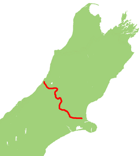
State Highway 7 is a major New Zealand state highway. One of the eight national highways, it crosses the Southern Alps to link the West Coast Region with Canterbury and to form a link between the South Island's two longest highways, State Highway 1 and State Highway 6. Distances are measured from east to west with the major junction list going from east to west.

New Zealand State Highway 30 road in New Zealand

State Highway 30 (SH 30) is a New Zealand state highway, linking the Waikato and Bay of Plenty towns of Te Kuiti, Mangakino, Rotorua, and Whakatane.

New Zealand State Highway 94 road in New Zealand

State Highway 94 is a New Zealand state highway connecting the large Southland town of Gore with one of New Zealand's most popular destinations, Milford Sound. It also passes the significant townships of Lumsden and Te Anau as well going through the Homer Tunnel. The road also goes through Fiordland and crosses the Main Divide of the Southern Alps.

New Zealand State Highway 73 road in New Zealand

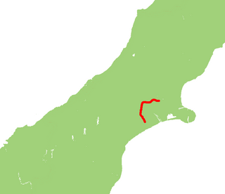
State Highway 73 is a major east-west South Island state highway in New Zealand connecting Christchurch on the east coast with Cass/Hokitika via the Southern Alps. It is mostly two lane, with some single-lane bridges north of Springfield but is mostly dual carriageway in Christchurch. The fourth and fifth-highest points of New Zealand's state highway network are on this road at Porters Pass and Arthur's Pass respectively.

New Zealand State Highway 75 road in New Zealand

State Highway 75 (SH 75) is a state highway in New Zealand servicing the Banks Peninsula region, connecting Christchurch on the northwestern part of the peninsula with Akaroa towards the east coast. It is wholly two lane, but partially functions as a major arterial corridor of Christchurch. Its highest point is at Hilltop, where it rises to about 555 m - just 8 m lower than the more mountainous Haast Pass in the Southern Alps.

New Zealand State Highway 77 road in New Zealand

State Highway 77 is a state highway in New Zealand going through the inland parts of Central and Mid Canterbury between the towns of Ashburton and Darfield via the Rakaia Gorge. It is wholly single carriageway with two one-lane bridges at the Rakaia and Selwyn Rivers. One set of traffic lights is found in Ashburton marking the southern terminus of the highway.

New Zealand State Highway 57 road in New Zealand

State Highway 57 is a New Zealand state highway, linking State Highway 1 north of Ohau to State Highway 3 east of Ashhurst, via Levin, Shannon, Massey University and the southern suburbs of Palmerston North. The highway connects State Highway 1 traffic coming north from Wellington to the city of Palmerston North, and further to the Manawatu Gorge, allowing passage to the eastern side of the North Island and to the twin cities of Napier and Hastings. The highway is classified by the NZTA as a national strategic road.

State Highway 79 (SH 79) is a New Zealand state highway connecting the South Canterbury communities of Rangitata, Geraldine, and Fairlie. Starting at State Highway 1 the highway is 61 kilometres in length and runs in a general east-west direction. 6.3 km of the highway through Geraldine runs concurrently with the Inland Scenic Route, formerly State Highway 72. The road is a two-lane single carriageway, with a one-lane bridge crossing the Orari River.

State Highway 97 (SH 97) is a New Zealand State Highway connecting the settlements of Five Rivers and Mossburn in the Southland region. The highway was gazetted in 2004 to reflect the increasing amount of traffic between the tourist destinations of Queenstown and Fiordland National Park and provides a bypass of the town of Lumsden, where SH 6 and 94 intersect.

State Highway 54 (SH 54) is a New Zealand state highway in the Manawatu district in the North Island. It runs from SH 3 at Newbury to SH 1 near Hunterville. This highway connects the Manawatu agricultural town of Feilding as well as forming an alternative route to travel from the Central North Island volcanic plateau to the city of Palmerston North.

State Highway 61 (SH 61) is a former New Zealand state highway in the Tasman Region of the South Island. It links the coastal town of Motueka with SH 6, the main route to the South Island's West Coast. Along with several other state highways, its status was revoked at the beginning of the 1990s. The route is now usually referred to as the Motueka Valley Highway.

References