Seddonville

Last updated

Seddonville
Seddonville in 2009.jpg
Seddonville in 2009
NZ-West Coast plain map.png
Disc Plain red.svg
Seddonville
Coordinates: 41°33′6″S171°59′24″E / 41.55167°S 171.99000°E / -41.55167; 171.99000
CountryNew Zealand
Region West Coast
District Buller District
Electorates West Coast-Tasman
Te Tai Tonga
Population
 (2013)
  Total53
Historical Seddonville (time ca early 20th century) Seddonville Coal Processing.jpg
Historical Seddonville (time ca early 20th century)

Seddonville is a lightly populated locality [1] on the West Coast of New Zealand's South Island. It is most famous for the historical role it played in New Zealand's coal mining industry.

Contents

Geography

Seddonville is in the isolated north of the West Coast in the foothills of the Glasgow Range, on the southern bank of the Mokihinui River. To the west are Summerlea and Mokihinui on the coast of the Tasman Sea, and to the north is Corbyvale on the road to Karamea. State Highway 67 ends just before reaching Seddonville.

In 1911 Seddonville's population was 426, [2] 222 in 1951, [3] 70 in 1976 [4] and in 2013 its 3 meshblocks totalled 53. [5]

A rare mollusc, Powelliphanta lignaria rotella , is found only in the Seddonville area. It is considered nationally endangered. [6]

Mokihinui River Gorge as viewed from Seddonville Mokihinui Gorge from Seddonville.jpg
Mokihinui River Gorge as viewed from Seddonville
Road to Utopia - Seddonville Utopia Road Seddonville.jpg
Road to Utopia – Seddonville

History

Seddonville was named after Prime Minister of New Zealand Richard Seddon. It was established in the late 19th century as a mining community after the discovery of significant coal reserves in the area. Several mines nearby opened, with varying degrees of success, [7] until the last one closed in 1986, due to having up to 6% sulphur in its coal. [8]

Coal was first discovered in 1862, [9] when the Nelson and Mokihinui Coal Mining Company Ltd was formed. [10] However, dense bush made the seams hard to locate, [11] so mining didn't begin until about 1869. [12] By 1874 a short tramway had been built to the river and barges started taking the coal to the river mouth. [13] A Wellington and Mokihinui Coal Mining Company was formed in 1877 [14] and was exploring a seam by 1880, [15] but didn't open the mine until 1885. [16] In 1889 the company raised further money to develop the mine and arranged for the river bar to be dredged [17] and a wharf built [18] for use by the former Newcastle steam collier, Lawrence. [19] She was wrecked on the bar in 1891 [20] and remnants can still be seen on the beach. [21]

A mine at Chasm Creek opened in 1892, the year before Dick Seddon opened the railway and his name was given to the village. [22] One of the earliest state-owned mines opened in 1903, but was worked out by 1914. [23] Charming Creek mine, between Seddonville and Ngakawau, [24] opened in 1929, employed about 70 men, producing over 40,000 tonnes a year in the 1940s and closed in 1986. Its former railway now forms the Charming Creek walkway from Ngakawau. [25]

On 23 February 1895, the last section of the Seddonville Branch railway from Westport was opened from Mokihinui to Seddonville and included an extension to the Mokihinui Coal Company's mine. Passengers were catered for by mixed trains; after 12 June 1933, they ceased to carry passengers past Seddonville, and on 14 October 1946 they were cancelled. Coal was the predominant traffic, especially after the late 1930s when increasingly developed roads allowed most other freight to be carried by road. In 1974, the Mokihinui Coal Company's mine closed, as did the railway beyond Seddonville. Coal from other mines provided some freight for the rest of the decade, but mining production was in decline and demand had dropped, and by 1980 the maintenance cost was well in excess of revenue. The railway closed beyond Ngakawau on 3 May 1981. [26]

Modern age

Seddonville is now a small rural village. It provides access to the Mokihinui back country and fishing, tramping, and whitewater rafting attract visitors. [27] The gates to Seddonville Domain form a small war memorial, commemorating 18 men from Seddonville: 13 in World War I and five in World War II. [28] Seddonville houses the H. E. Holland Memorial Library, which was named in honour of local MP and first leader of the Labour Party, Harry Holland, who made a public appeal to replace the collection after the first library was destroyed by flooding in 1929. [29] [30]

Part of the route of the railway is preserved as the Chasm Creek Walkway. On the approach to Seddonville, it follows the formation of the line, passes through a tunnel and over two railway bridges. The platform of Seddonville railway station is still extant in the village. [31] The Old Ghost Road, a mountain biking and walking track, finishes in Seddonville. [32]

Related Research Articles

<span class="mw-page-title-main">Ahaura River</span> River in the South Island of New Zealand

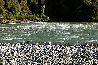
The Ahaura River is in the South Island of New Zealand. This river drains the western flanks of the Southern Alps and flows into the Grey River.

<span class="mw-page-title-main">Awarau River</span> River in New Zealand

The Awarau River, usually known as Larry's Creek is located within the South Island of New Zealand. The river is about 27 kilometres (17 mi) long and runs northwest from its headwaters in the Victoria Range to its confluence with the Inangahua River north of Reefton. It also drains part of the Brunner Range and there was a track along that range linking to Lyell by 1901, though none existed in 1874. A track also ran south over Kirwan Hill to the Montgomerie River.

<span class="mw-page-title-main">Buller River</span> River in New Zealand

The Buller River is a river in the South Island of New Zealand. The Buller has the highest flow of any river in the country during floods, though it is only the 13th longest river; it runs for 177 km (110 mi) from Lake Rotoiti through the Buller Gorge and into the Tasman Sea near the town of Westport. A saddle at 710 m (2,330 ft) separates the Buller from the Motupiko River and that is divided from the Wairau River by a 695 m (2,280 ft) saddle, both aligned along the Alpine Fault, as is the top of the Buller valley.

<span class="mw-page-title-main">Cape Foulwind</span>

Cape Foulwind is a headland on the West Coast of the South Island of New Zealand, overlooking the Tasman Sea. It is located 11 kilometres (6.8 mi) west of the town of Westport. There is a lighthouse located on a prominent site on the headland. A walkway beginning at the lighthouse carpark traverses the rocky headland to Tauranga Bay and passes close by a colony of New Zealand fur seals. There is limestone quarry in the area, and a cement works operated nearby from 1958 to 2016.

<span class="mw-page-title-main">Stillwater–Ngākawau Line</span> Railway line in New Zealand

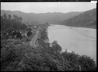
The Stillwater Ngākawau Line (SNL), formerly the Stillwater–Westport Line (SWL) and the Ngakawau Branch, is a secondary main line, part of New Zealand's national rail network. It runs between Stillwater and Ngakawau via Westport on the West Coast of the South Island. It was one of the longest construction projects in New Zealand's history, with its first section, at the south end, opened in 1889, and the beginnings of the Ngākawau Branch, at its Westport end, in 1875. The full line was completed in 1942. The only slower railway projects were Palmerston North to Gisborne, 1872 to 1942, and the Main North Line to Picton, 1872 to 1945.

<span class="mw-page-title-main">Seddonville Branch</span>

The Seddonville Branch, later truncated as the Ngākawau Branch, is a branch line railway in the West Coast region of New Zealand's South Island. Construction began in 1874 and it reached its terminus at the Mokihinui Mine just beyond Seddonville in 1895. In 1981 it was closed past Ngākawau and effectively became an extension of the Stillwater–Westport Line, since formalised as the Stillwater–Ngākawau Line.

The Glasgow Range is a mountain range on the northern West Coast of New Zealand's South Island. It is north of the Papahaua Range and its most significant river is the Mōkihinui River.

<span class="mw-page-title-main">Mōkihinui River</span> River in New Zealand

The Mōkihinui River is a river located on the West Coast of New Zealand's South Island, about 40 kilometres north of Westport. Meridian Energy had proposed the Mokihinui Hydro project on the river in 2007 but it was cancelled in May 2012. In 2019, it was announced that large parts of the river catchment, including 15 km (9.3 mi) of river bed, would be added to Kahurangi National Park.

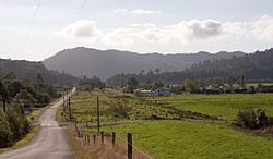
Summerlea is a lightly populated locality on the West Coast of New Zealand's South Island.

<span class="mw-page-title-main">Hector and Ngakawau</span> Town on the West Coast of the South Island of New Zealand

Hector and Ngakawau are two lightly populated settlements located at the mouth of the Ngākawau River in the West Coast region of New Zealand. Both settlements are situated on State Highway 67 between Westport and Karamea. Despite a low population, many of the workers at New Zealand's largest open-cut coal mine at Stockton choose to live at these places and shuttles frequently operate between the two places.

<span class="mw-page-title-main">Ngākawau River</span> River in New Zealand

The Ngākawau River is a river of the West Coast Region of New Zealand's South Island. It flows generally northwest, reaching the Tasman Sea at Hector.

<span class="mw-page-title-main">Glen Afton Branch</span>

The Glen Afton Branch was a branch railway line of 7.9 km in the Waikato in New Zealand, built to serve coal mines in the Awaroa district west of Huntly at Rotowaro, Pukemiro and Glen Afton. Rotowaro is Māori for "coal lake".

<span class="mw-page-title-main">Mokihinui</span> Place in West Coast, New Zealand

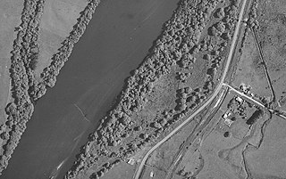
Mokihinui is a lightly populated locality on the West Coast of New Zealand's South Island.

The Huntly rail bridge bombing occurred on the Glen Afton Branch, near Huntly, New Zealand around 3 a.m. on 30 April 1951, when high explosives were set off on a railway bridge. The bombing took place amid the 1951 New Zealand waterfront dispute, an industrial dispute over the working conditions and wages of dockworkers. Characterised by the-then Prime Minister Sidney Holland as an act of terrorism, the bombing caused no casualties, even though a morning passenger train ran over the weakened bridge. The perpetrators remain unknown.

<span class="mw-page-title-main">Charming Creek Tramway</span>

The Charming Creek Tramway was a 9 kilometres (5.6 mi) long private bush tramway at Ngakawau in Buller District on the West Coast in New Zealand. It was used from 1903 or 1905 to 1958.

<span class="mw-page-title-main">Kimihia railway station</span> Railway station in New Zealand

Kimihia Railway Station was on the North Island Main Trunk line, north of Huntly in the Waikato District of New Zealand. The station was in 1886 measured as 19 mi 33 ch (31.2 km) south of Mercer, which is where an unnamed block is shown on the 1929 map, near the junction of Fisher Road with SH1, about 1.4 km (0.87 mi) north of the junction with the Kimihia branch. That junction was 101.06 km (62.80 mi) south of Auckland and 576.54 km (358.25 mi) from Wellington.

Glen Murray is a rural community in the Waikato District and Waikato region of New Zealand's North Island, on Highway 22, about 6 km (3.7 mi) up the Tikotiko Stream from Lake Whangape. In 2013 the population of meshblock 0846601, which includes Glen Murray, was 42. It has a garage and a War Memorial Hall, which opened in 1952. It is named after William Murray, who moved from Piako in 1885.

Āria is a rural community in the Waitomo District and Waikato region of New Zealand's North Island.

<span class="mw-page-title-main">Puketutu railway station</span> Railway station in New Zealand

Puketutu was a flag station on the North Island Main Trunk line, in the Waitomo District of New Zealand.

Te Koura was flag station on the North Island Main Trunk line, in the Ruapehu District of New Zealand in the Ōngarue valley. When opened in 1903 it had sidings, a platform and a goods shed, The line was useable from February 1903 and goods traffic started on 22 June 1903.

References

  1. "Place name detail: Seddonville". New Zealand Gazetteer. New Zealand Geographic Board . Retrieved 23 June 2007.
  2. "Report on the results of a census of the Dominion of New Zealand, taken for the night of the 2nd April, 1911" (PDF).
  3. "1951 Census - Part 01 - Increase and Location of Population 1951". statsnz.contentdm.oclc.org. Retrieved 19 November 2022.
  4. 1976 Census of Population and Dwellings. The Department of Statistics. 1977.
  5. "Population by meshblock (2013 Census)". datafinder.stats.govt.nz. Retrieved 19 November 2022.
  6. Department of Conservation, New Zealand Threat Classification System lists – 2002 – Terrestrial invertebrate – part one Archived 15 October 2008 at the Wayback Machine , accessed 23 June 2007.
  7. "Seddonville: forgotten coal town". nzhistory.govt.nz. 11 December 2015. Retrieved 15 April 2022.
  8. "Decline of mining". nzhistory.govt.nz. 11 December 2015. Retrieved 15 April 2022.
  9. "COLONIST". paperspast.natlib.govt.nz. 2 May 1862. Retrieved 15 April 2022.
  10. "NELSON EXAMINER AND NEW ZEALAND CHRONICLE". paperspast.natlib.govt.nz. 19 November 1862. Retrieved 15 April 2022.
  11. "Correspondence. NELSON EXAMINER AND NEW ZEALAND CHRONICLE". paperspast.natlib.govt.nz. 24 November 1863. Retrieved 15 April 2022.
  12. "WEST COAST TIMES". paperspast.natlib.govt.nz. 5 March 1869. Retrieved 15 April 2022.
  13. "MOKIHINUI COAL MINES. WESTPORT TIMES". paperspast.natlib.govt.nz. 23 June 1874. Retrieved 15 April 2022.
  14. "THE PROPOSED MOKIHINUI COAL MINING COMPANY. GREY RIVER ARGUS". paperspast.natlib.govt.nz. 6 June 1877. Retrieved 15 April 2022.
  15. "MOKIHINUI COAL. WESTPORT TIMES". paperspast.natlib.govt.nz. 2 July 1880. Retrieved 15 April 2022.
  16. "GREY RIVER ARGUS". paperspast.natlib.govt.nz. 13 April 1885. Retrieved 15 April 2022.
  17. "WEST COAST TIMES". paperspast.natlib.govt.nz. 18 February 1889. Retrieved 15 April 2022.
  18. "OVERLAID FROM SEA TO SEA. NELSON EVENING MAIL". paperspast.natlib.govt.nz. 5 June 1889. Retrieved 15 April 2022.
  19. "SHIPPING TELEGRAMS. WEST COAST TIMES". paperspast.natlib.govt.nz. 7 September 1889. Retrieved 15 April 2022.
  20. "THE LAWRENCE. WEST COAST TIMES". paperspast.natlib.govt.nz. 15 May 1891. Retrieved 15 April 2022.
  21. PhilBee NZ (social historian) (24 January 2018), Mokihinui: wreck of the "SS Lawrence" (c.1884) (10) , retrieved 15 April 2022
  22. "Coal is discovered". nzhistory.govt.nz. 1 September 2014. Retrieved 15 April 2022.
  23. "Seddonville State Mine". nzhistory.govt.nz. 20 December 2012. Retrieved 15 April 2022.
  24. "Charming Creek Coal Mine, West Coast". NZ Topo Map. Retrieved 15 April 2022.
  25. "Mining at Charming Creek". nzhistory.govt.nz. 20 December 2012. Retrieved 15 April 2022.
  26. David Leitch and Brian Scott, Exploring New Zealand's Ghost Railways, rev. ed. (Wellington: Grantham House, 1998), 52–3.
  27. Tourism West Coast, "Mokihinui / Seddonville", accessed 23 June 2007.
  28. Simon Nathan, "Seddonville War Memorial", accessed 23 June 2007.
  29. "Harry Holland memorial library". NZHistory.net. Retrieved 6 July 2015.
  30. "Echo of the Earthquake: New library at Seddonville opened". paperspast.natlib.govt.nz. Retrieved 14 October 2020.
  31. Leitch and Scott, Exploring New Zealand's Ghost Railways, 53-4.
  32. "Old Ghost Road". New Zealand Cycle Trail . Retrieved 14 July 2022.