
Westport is a town in the West Coast region of the South Island of New Zealand. Established in 1861, it is the oldest European settlement on the West Coast. Originally named Buller, it is on the right bank and at the mouth of the Buller River, close by the prominent headland of Cape Foulwind. It is connected via State Highway 6 with Greymouth, 100 kilometres (62 mi) to the south, and with Nelson 222 kilometres (138 mi) in the northeast, via the Buller Gorge. The population of the Westport urban area was 4,250 as of June 2023. The Buller District had a population of 9,670.
Waimangaroa is a small town located on the West Coast of New Zealand.
The Ohai Line, formerly known as the Ohai Industrial Line and previously the Wairio Branch and the Ohai Railway Board's line, is a 54.5 km branch line railway in Southland, New Zealand. It opened in 1882 and is one of two remaining branch lines in Southland, and one of only a few in the country. A number of smaller privately owned railways fanned out from Wairio; one of these lines, to Ohai, was originally built by the Ohai Railway Board and was worked by New Zealand Railways from 1990 and incorporated into the national network in 1992.

The NZR WB class was a class of tank locomotives that operated in New Zealand. Built in 1898 by the Baldwin Locomotive Works, the twelve members of the class entered service during the first five months of 1899. Eight were withdrawn by the end of 1935, while four others survived with new boilers until the mid-1950s.
Ngahere is a locality in the Grey District of the West Coast of New Zealand's South Island. The 2013 New Zealand census gave the population of Ngahere and its surrounding area as 363, an increase of 5.2% or 18 people since the 2006 census. Ngahere is located on the south bank of the Grey River, and State Highway 7 and the Stillwater–Westport Line (SWL) railway pass through the village.
The Papahaua Range is a mountain range on the West Coast of New Zealand's South Island east of the town of Westport. It is a geological continuation of the Paparoa Range that is south of the Buller River and it runs north from the Buller Gorge to the Mōkihinui River. At its north end, it meets the Glasgow Range.

The Seddonville Branch, later truncated as the Ngākawau Branch, is a branch line railway in the West Coast region of New Zealand's South Island. Construction began in 1874 and it reached its terminus at the Mokihinui Mine just beyond Seddonville in 1895. In 1981 it was closed past Ngākawau and effectively became an extension of the Stillwater–Westport Line, since formalised as the Stillwater–Ngākawau Line.

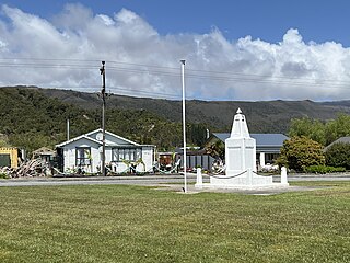
Seddonville is a lightly populated locality on the West Coast of New Zealand's South Island. It is most famous for the historical role it played in New Zealand's coal mining industry.
The Glasgow Range is a mountain range on the northern West Coast of New Zealand's South Island. It is north of the Papahaua Range and its most significant river is the Mōkihinui River.
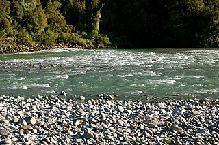
The Mōkihinui River is a river located on the West Coast of New Zealand's South Island, about 40 kilometres north of Westport. Meridian Energy had proposed the Mokihinui Hydro project on the river in 2007 but it was cancelled in May 2012. In 2019, it was announced that 64,400 ha of land in the Mōkihinui River catchment, including 15 km (9.3 mi) of river bed, would be added to Kahurangi National Park.

Hector and Ngakawau are two lightly populated settlements located at the mouth of the Ngākawau River in the West Coast region of New Zealand. Both settlements are situated on State Highway 67 between Westport and Karamea. Despite a low population, many of the workers at New Zealand's largest open-cut coal mine at Stockton choose to live at these places and shuttles frequently operate between the two places.
Sergeants Hill is a lightly populated locality in the West Coast region of New Zealand's South Island. It is situated in a rural setting on the eastern outskirts of Westport in the Buller District.
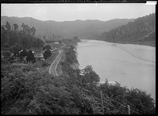
The Conns Creek Branch was a 2.7 kilometre branch line railway in the West Coast region of New Zealand's South Island. It diverged from the Seddonville Branch at Waimangaroa and followed the southern bank of the Waimangaroa River to the line's terminus at Conns Creek at the foot of the Denniston Incline. The line operated from 1877 until 1967 and existed for the sole purpose of conveying coal from mines to the port of Westport.
Taumarere is a locality in the Bay of Islands in Northland, New Zealand. The Kawakawa River and State Highway 11 run through Taumarere. The town of Kawakawa is 3 km to the southwest. Opua is 7 km to the north and Paihia 14 km.
State Highway 67 (SH 67) is a New Zealand state highway located in the northern parts of the South Island of New Zealand. It is 51.2 km long usually on the coast and connects SH 6 with the settlement of Mokihinui. It used to be 96 kilometres long and ran the entire length of the road from Westport to Karamea The highway and its spur serves the large West Coast town of Westport and lies entirely within the Buller District.
The Mokihinui Hydro was a proposed hydroelectric dam and power station planned for conservation land on the Mōkihinui River on the West Coast of New Zealand. The project by Meridian Energy was expected to cost $300 million.

The Ngākawau River is a river of the West Coast Region of New Zealand's South Island. It flows generally northwest, reaching the Tasman Sea at Hector.
Mokihinui is a lightly populated locality on the West Coast of New Zealand's South Island.
Strathfield is a rural locality in the Isaac Region, Queensland, Australia. In the 2021 census, Strathfield had a population of 8 people.

The Old Ghost Road is a mountain bike and tramping trail part-funded as one of the projects of the New Zealand Cycle Trail (NZCT) system in the Buller District of New Zealand. Of all NZCT projects, it is the technically most difficult one to ride and is rated "advanced". The highest point of the trail is at 1,280 metres (4,200 ft).
