
The Buller River is a river in the South Island of New Zealand. The Buller has the highest flow of any river in the country during floods, though it is only the 13th longest river; it runs for 177 km (110 mi) from Lake Rotoiti through the Buller Gorge and into the Tasman Sea near the town of Westport. A saddle at 710 m (2,330 ft) separates the Buller from the Motupiko River and that is divided from the Wairau River by a 695 m (2,280 ft) saddle, both aligned along the Alpine Fault, as is the top of the Buller valley.

Paparoa National Park is on the west coast of the South Island of New Zealand. The park was established in 1987 and encompasses 430 km2 (170 sq mi). The park ranges from or near the coastline to the peaks of the Paparoa Range. A separate section of the park lies to the north and is centred at Ananui Creek. The park protects a limestone karst area. The park contains several caves, of which Metro Cave / Te Ananui Cave is a commercial tourist attraction. The majority of the park is forested with a wide variety of vegetation. The park was the site of the 1995 Cave Creek disaster where fourteen people died as a result of the collapse of a scenic viewing platform.
Punakaiki is a small village on the West Coast of the South Island of New Zealand. It is located between Westport and Greymouth on State Highway 6, the only through-road on the West Coast. Punakaiki is immediately adjacent to Paparoa National Park, and is also the access point for a popular visitor attraction, the Pancake Rocks and Blowholes.
The Cave Creek disaster occurred on 28 April 1995 when a scenic viewing platform in Paparoa National Park, New Zealand, collapsed, resulting in the deaths of 14 people. The victims, 13 of whom were Tai Poutini Polytechnic students, fell 40 metres (130 ft) onto rocks below. The tragedy resulted in wide criticism of the government and its policies towards funding and management of the conservation estate. Denis Marshall, New Zealand's Minister of Conservation, eventually resigned, after the Commission of Inquiry's report came out. It also resulted in major changes to procedures used by the New Zealand Department of Conservation after it was revealed that serious systemic failures had led to the building of the unstable platform. Eventual changes in New Zealand law, following a change of government, allowed for government departments to be held criminally liable for inadequate building practices, in the same way as non-government organisations.
The Abel Tasman Coast Track is a 60 kilometres (37 mi) long walking track within the Abel Tasman National Park in New Zealand. It extends from Mārahau in the south to Wainui in the north, with many side tracks. It is one of two main tracks through the park, the other being the Abel Tasman Inland Track, which stretches for 38 km between Tinline Bay and Torrent Bay off the main coastal track. The coastal track is well sheltered, and with mild weather in all seasons, it is accessible and open throughout the year.

The Paparoa Range is a mountain range in the West Coast region of New Zealand's South Island. It was the first New Zealand land seen by a European – Abel Tasman in 1642. Part of the range has the country's highest protection as a national park; the Paparoa National Park was established in 1987. Within that park, the Cave Creek disaster occurred in 1995.

The Punakaiki River is a river of the West Coast Region of New Zealand's South Island. It flows predominantly northwest from its sources in the Paparoa Range, reaching the Tasman Sea two kilometres south of the town of Punakaiki. Most of the river's length is within Paparoa National Park.

The Fox River is a river in the Buller District of New Zealand. It arises in the Paparoa Range near Mount Dewar and flows north-west through the Paparoa National Park to the Tasman Sea at Woodpecker Bay. The river passes through a spectacular gorge. The northern branch of the river has limestone caves containing stalactite and stalagmite formations.
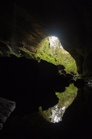
The Metro / Te Ananui Caves are a maze of limestone caves formed by the underground capture of Ananui Creek, a tributary of the Waitakere / Nile River. The caves are located in the Paparoa National Park in New Zealand, managed by the Department of Conservation. Parts of the cave system are accessible by cave tours and rafting, operated by a commercial tour operator out of Charleston.

The Paparoa Track is a 55.7 km (34.6 mi) shared hiking and mountain biking track located in Paparoa National Park in the South Island of New Zealand. The track was created as a memorial for the 29 miners who lost their lives in the Pike River Mine disaster. The track is the tenth Great Walk to be created and has been fully open since 1 March 2020. It was the first addition to the Great Walks in 25 years.

Cave Creek / Kotihotiho is a small river within Paparoa National Park, on the West Coast of New Zealand's South Island.

Punakaiki Marine Reserve is a marine reserve administered by the Department of Conservation. The reserve includes the area of sea surrounding the pancake rocks and blowholes at Dolomite Point, at Punakaiki on the West Coast Region of New Zealand's South Island. It also includes most of the coastline on the western edge of Paparoa National Park.
The Barrytown Flats are a 17 km (11 mi) coastal plain north of Greymouth on the West Coast of New Zealand's South Island. A series of postglacial shorelines and dunes backed by a former sea cliff, they was originally covered with wetland and lowland forest, including numerous nīkau palms. The sands were extensively sluiced and dredged for gold from the 1860s, centred on the small settlement of Barrytown. The drier areas of the flats have been converted into pasture, but significant areas of forest remain, including Nikau Scenic Reserve. The flats are bordered by Paparoa National Park and the only breeding site of the Westland petrel. There are significant deposits of ilmenite in the Barrytown sands, and there have been several mining proposals, but the possible environmental consequences have been contentious.
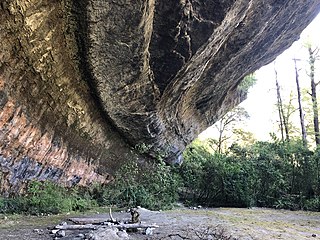
The Ballroom Overhang is a large limestone outcrop on the Fox River in Paparoa National Park, in the Buller District of New Zealand. The Ballroom Overhang provides a sheltered place for resting or overnight camping. The overhang is 10 m (33 ft) at its highest point, 100 m (330 ft) long, and 30 m (98 ft) at its widest point.
Bullock Creek or Punungairo is a river valley in the Paparoa National Park, located just north of Punakaiki on the West Coast of New Zealand. It includes a rare and nationally significant polje, a large, flat-floored depression within karst limestone. The Bullock Creek polje is New Zealand's only example of this type of landform.

The Inland Pack Track is a trail in the Paparoa National Park on West Coast of New Zealand. The full length of the trail commences at the Punakaiki River in the south, and ends at the mouth of the Fox River in the north. It takes two or three days to complete the track.

The Croesus Track is a 22.1 km (13.7 mi) historic miners trail to the south of Paparoa National Park in the Grey District of South Island of New Zealand. The route crosses the Paparoa Range from Blackball in the Grey Valley to Barrytown on the Tasman Sea coast. The first section, starting from the Blackball end, is shared with the Paparoa Track which follows the route of the Croesus Track to top of the Paparoa Range. This section is shared-use between hiking and mountain biking.

The Pike29 Memorial Track is a hiking track located near the Paparoa National Park in the Grey District of the South Island of New Zealand. The track was created as a memorial for the 29 miners who lost lives in the Pike River Mine disaster. The track is a branch of the Paparoa Track, the tenth Great Walk created. Both tracks were originally scheduled to open in 2018. The Pike29 Memorial Track opened in February 2024, four years after the Paparoa Track. The Pike River Mine portal features a memorial and interpretation centre.

The Waitakere / Nile River is a river on the West Coast of New Zealand's South Island. It rises in the Paparoa Range and flows through a limestone karst landscape in a roughly northwest direction for its entire length, reaching the Tasman Sea just north of Charleston. The river and its surrounds are a popular tourist destination, particularly for a bush train along the river's canyon and caving through the nearby Metro / Te Ananui Caves. The lower reaches of the river are also a popular fishing spot, particularly for brown trout.

Ship Creek is a small river that flows into an area of coastal swamp forest on the West Coast of New Zealand's South Island. Ship Creek is approximately 11 km (6.8 mi) long and flows northwest from catchment areas on the slopes of Bald Hill, reaching the Tasman Sea around 20 km (12 mi) north-east of Haast. Near the mouth of Ship Creek, there are short walks around dune lakes and ancient kahikatea swamp forest.
 Pororari River upstream of the gorge
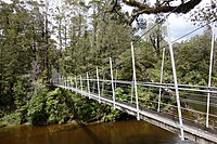 Suspension bridge on the Inland Pack Track
 Pororari River Track
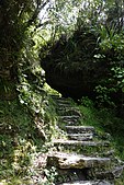 Steps on the Pororari River Track
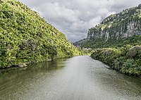 Pororari Gorge
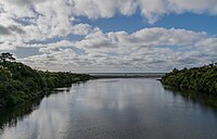 Pororari River from SH6, with Tasman Sea as a backdrop
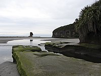 Pororari Lagoon


