
Karamea is a town on the West Coast of the South Island of New Zealand. It is the northernmost settlement of any real size on the West Coast, and is located 96 kilometres (60 mi) northeast by road from Westport. Apart from a narrow coastal strip, the town of Karamea and its local area are completely surrounded to the south, east and north by Kahurangi National Park.

Kahurangi National Park in the northwest of the South Island of New Zealand is the second largest of the thirteen national parks of New Zealand. It was gazetted in 1996 and covers 5,193 km2 (2,005 sq mi), ranging from the Buller River near Murchison in the south, to the base of Farewell Spit in Golden Bay in the north. The park has no single dominant landform, but includes an unusually wide variety of landscapes, including mountain ranges, rivers, gorges, raised peneplains and karst features such as caves and arches. Many of the landforms within the park are considered to be nationally or internationally significant.

Paparoa National Park is on the west coast of the South Island of New Zealand. The park was established in 1987 and encompasses 430 km2 (170 sq mi). The park ranges from or near the coastline to the peaks of the Paparoa Range. A separate section of the park lies to the north and is centred at Ananui Creek. The park protects a limestone karst area. The park contains several caves, of which Metro Cave / Te Ananui Cave is a commercial tourist attraction. The majority of the park is forested with a wide variety of vegetation. The park was the site of the 1995 Cave Creek disaster where fourteen people died as a result of the collapse of a scenic viewing platform.

The Heaphy Track is a popular tramping and mountain biking track in the north west of the South Island of New Zealand. It is located within the Kahurangi National Park and classified as one of New Zealand's ten Great Walks by the Department of Conservation. Named after Charles Heaphy, the track is 78.4 kilometres (48.7 mi) long and is usually walked in four or five days. The track is open for shared use with mountain bikers in the winter season from 1 May to 30 September each year. The southern end of the track is at Kōhaihai, north of Karamea on the northern West Coast, and the northern end is in the upper valley of the Aorere River, Golden Bay.

Lake Matheson is a small glacial lake in South Westland, New Zealand, near the township of Fox Glacier. It was a traditional food-gathering place for local Māori. An easy walking track circles the lake, which is famous for its reflected views of Aoraki / Mount Cook and Mount Tasman.

The Oparara Basin Arches are a number of natural limestone tunnels formed by the Oparara River, in the Oparara Basin, New Zealand. The two most famous ones are the 'Oparara Arch', large enough for a multi-storey house, and the 'Moria Gate Arch', which is smaller in height.

The Ōpārara River is a river in the West Coast region of New Zealand's South Island. It is best known for the limestone arches it carved in the Oparara Basin.
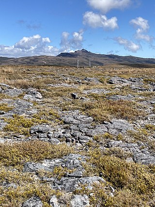
Denniston Plateau is an 18 km long, 600–800 m high coalfield plateau in the Papahaua Range on the West Coast of the South Island of New Zealand. A combination of impermeable rock, high rainfall, and shallow acidic soil has created a unique ecosystem of stunted trees and heath-like vegetation which is home to numerous endemic and undescribed species of plants and invertebrates. The plateau contains rich seams of high-quality coal, which led to the creation and abandonment of the mining towns of Denniston and Millerton, and the current Stockton Mine. Plans to create a new open-cast mine on the southern part of the plateau have become an environmental controversy.

Pirongia Forest Park is a protected area 30 km southwest of Hamilton, New Zealand. It covers 167.7 square kilometres (64.7 sq mi) across four blocks of land - Pirongia, Te Maunga O Karioi Block, and the small Mangakino Block and Te Rauamoa Block. The park encompasses Mount Pirongia west of Pirongia and Mount Karioi near the coast southwest of Raglan. Wairēinga / Bridal Veil Falls Scenic Reserve is located nearby, but is separate to Pirongia Forest Park.
The Ōpārara Basin is a basin drained by the Ōpārara River at 20 kilometres (12 mi) north of Karamea, at the West Coast Region of the South Island of New Zealand. With its large natural rock arches, a network of caves rich in fossils, and a beautiful, unspoiled natural environment typical of temperate rainforests, it is one of the most striking places of the Kahurangi National Park.
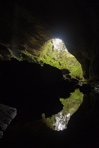
The Metro / Te Ananui Caves are a maze of limestone caves formed by the underground capture of Ananui Creek, a tributary of the Waitakere / Nile River. The caves are located in the Paparoa National Park in New Zealand, managed by the Department of Conservation. Parts of the cave system are accessible by cave tours and rafting, operated by a commercial tour operator out of Charleston.

Lake Gault is a small glacial lake in South Westland, New Zealand, near the township of Fox Glacier. A walking track from Lake Matheson leads to the lake, which is surrounded by mature native forest. A small hydro-electric power plant was constructed piping water from the lake to power a gold mining dredge at Gillespies Beach. Endangered Ōkārito kiwi (rowi) have been released into the wild around Lake Gault.
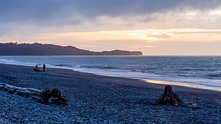
Gillespies Beach is a black sand beach and settlement on the West Coast of New Zealand's South Island, 20 kilometres (12 mi) west of Fox Glacier township by road. It is bounded by Westland Tai Poutini National Park to the east, and the Tasman Sea to the west. The beach itself stretches about five kilometres (3.1 mi) from Gillespies Point / Kōhaihai in the north to Otorokua Point in the south.
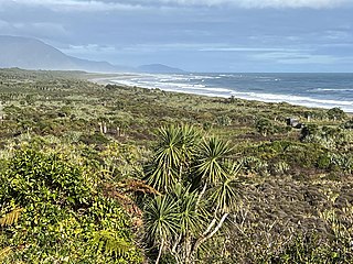
The Barrytown Flats are a 17 km (11 mi) coastal plain north of Greymouth on the West Coast of New Zealand's South Island. A series of postglacial shorelines and dunes backed by a former sea cliff, they was originally covered with wetland and lowland forest, including numerous nīkau palms. The sands were extensively sluiced and dredged for gold from the 1860s, centred on the small settlement of Barrytown. The drier areas of the flats have been converted into pasture, but significant areas of forest remain, including Nikau Scenic Reserve. The flats are bordered by Paparoa National Park and the only breeding site of the Westland petrel. There are significant deposits of ilmenite in the Barrytown sands, and there have been several mining proposals, but the possible environmental consequences have been contentious.
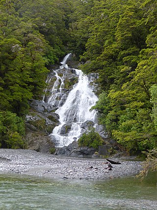
Fantail Falls is a waterfall in Mount Aspiring National Park, Westland District, New Zealand.

The Wangapeka Track is a tramping track in the north-west of the South Island of New Zealand. It is one of the main tramping tracks in the Kahurangi National Park, a protected area managed by the Department of Conservation. The route traverses the southern end of the park, from the historic Wangapeka goldfields area west of Tapawera, to the coastal plains of the West Coast at Little Wanganui. The route is 59 km (37 mi) long, and crosses the Wangapeka and Little Wanganui saddles, each over 1,000 m (3,300 ft) in elevation. The track passes through the valleys of the Wangapeka River, Karamea River, Taipō River and Little Wanganui River. The majority of the track is in river valleys and under forest cover, with small sections in tussock land at Stag Flat and the Little Wanganui Saddle. It typically takes walkers 4–6 days to complete the route.

The historic Haast to Paringa Cattle Track is a trail through South Westland, New Zealand, constructed in 1875 to allow farmers in the Landsborough and Cascade Valley area to drive their cattle on an annual two-week journey to the sale yards in Whataroa. It was constructed as an inland loop to bypass the precipitous cliffs at Knights Point. For 90 years it was the only land access to the settlements of Haast and Jackson Bay, but the last mob of cattle was driven in 1961, and the construction of a highway connecting Paringa to Haast Pass in 1965 made it redundant. After falling into disuse, the cattle track was converted into a 33-kilometre (21 mi), three-day tramping track, opening in 1981. The track and its three huts are maintained by the New Zealand Department of Conservation.

Roaring Billy Falls is a waterfall in Mount Aspiring National Park, Westland District, New Zealand. It is located in the Haast River valley, around 30 km (19 mi) inland from Haast, near Eighteen Mile Bluff on State Highway 6. The falls are a 30-metre-high (98 ft) cascade on The Roaring Billy stream. The bottom of the cascade is at an elevation of around 80 metres (262 ft) where it flows into the Haast River.

Thunder Creek Falls is a waterfall in Mount Aspiring National Park, Westland District, New Zealand. It is located in the Haast River valley, around 52 kilometres (32 mi) inland from Haast, near the Gates of Haast bridge on State Highway 6. The falls are about 28 metres (92 ft) high and the base is at an elevation of around 120 metres (390 ft) where it flows into the Haast River.

Lake Hanlon is a 12.4-hectare (31-acre) lake on the West Coast of New Zealand's South Island, located 8 kilometres (5 mi) south of Little Wanganui.


 Miner's Cave
 Cave wētā in Miner's Cave
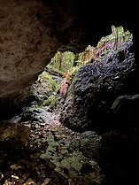 Tunnel Cave
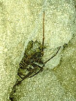 Spelungula in Tunnel Cave
 Cavern Creek Cave
 Spelungula egg sac in Cavern Creek Cave


