
A natural arch, natural bridge, or rock arch is a natural landform where an arch has formed with an opening underneath. Natural arches commonly form where inland cliffs, coastal cliffs, fins or stacks are subject to erosion from the sea, rivers or weathering.

Deua is a national park located in New South Wales, Australia, 320 kilometres (200 mi) south of Sydney, and 100 kilometres (62 mi) east of Canberra. The nearest towns on the coast are Batemans Bay, Moruya and Narooma.

Mole Creek Karst is a national park situated in the North of Tasmania, Australia, 168 km northwest of Hobart. It is located on the slopes of the Great Western Tiers to the east of the town of Mole Creek. It is the only national park in Tasmania created specifically to protect karst landforms. It is part of the Tasmanian Wilderness World Heritage Site.

Karamea is a town on the West Coast of the South Island of New Zealand. It is the northernmost settlement of any real size on the West Coast, and is located 96 kilometres (60 mi) northeast by road from Westport. Apart from a narrow coastal strip, the town of Karamea and its local area are completely surrounded to the south, east and north by Kahurangi National Park.

Kahurangi National Park is a national park in the northwest of the South Island of New Zealand. It is the second largest of the thirteen national parks of New Zealand. It was gazetted in 1996 and covers 5,193 km2 (2,005 sq mi), ranging from the Buller River near Murchison in the south, to the base of Farewell Spit in Golden Bay in the north. The park has no single dominant landform, but includes an unusually wide variety of landscapes, including mountain ranges, rivers, gorges, raised peneplains and karst features such as caves and arches. Many of the landforms within the park are considered to be nationally or internationally significant.

Harwoods Hole is a cave system located in the northwest of the South Island of New Zealand, in the Abel Tasman National Park. At 183 metres (600 ft), it is New Zealand's deepest vertical shaft. It was first explored in 1958, long after it was discovered.

Sanjay Gandhi National Park is an 87 km2 (34 sq mi) protected area in Mumbai, Maharashtra. It was established in 1969 with its headquarters situated at Borivali.

Tākaka Hill, previously also referred to as Marble Mountain, is a range of hills in the northwest of the South Island of New Zealand. Made of marble that has weathered into many strange forms and with numerous sink holes, it is typical karst country. The marble is Ordovician in age and from the Takaka Terrane.

Bulmer Cavern is New Zealand's longest cave system, running for 74.3 km (46.2 mi) through Mount Owen in the Tasman region of the northwest South Island. John Patterson discovered the cave on New Year's Day 1984, by dropping a rock down and counting the seconds until it reached the bottom.

Nettlebed Cave is a limestone cave located in the Mount Arthur region of the northwest South Island of New Zealand. The presence of ongaonga, an endemic tree nettle, near the bottom entrance gives the cave its name.

The upland moa is an extinct species of moa that was endemic to New Zealand. It is a ratite, a grouping of flightless birds with no keel on the sternum. It was the last moa species to become extinct, vanishing around 1500 CE, and was predominantly found in alpine and sub-alpine environments.

The Oparara Basin Arches are a number of natural limestone tunnels formed by the Oparara River, in the Oparara Basin, New Zealand. The two most famous ones are the 'Oparara Arch', large enough for a multi-storey house, and the 'Moria Gate Arch', which is smaller in height.

The Ōpārara River is a river in the West Coast region of New Zealand's South Island. It is best known for the limestone arches it carved in the Oparara Basin.

The Saint Arnaud Range is a mountain range in the central north of New Zealand's South Island. It lies between Lake Rotoiti and the upper reaches of the Wairau River, and marks the eastern boundary of Nelson Lakes National Park.
The Ōpārara Basin is a basin drained by the Ōpārara River at 20 kilometres (12 mi) north of Karamea, at the West Coast Region of the South Island of New Zealand. With its large natural rock arches, a network of caves rich in fossils, and a beautiful, unspoiled natural environment typical of temperate rainforests, it is one of the most striking places of the Kahurangi National Park.
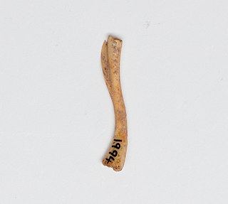
Markham's frog is one of three extinct New Zealand frog species, the others being the Aurora frog and Waitomo frog. Subfossil bones used to describe the species were discovered at Honeycomb Hill Cave, South Island, New Zealand, but it once occurred on both South and North Islands. It is estimated that it grew between 50 and 60 mm from snout to vent and it appears to have been a very robust animal.
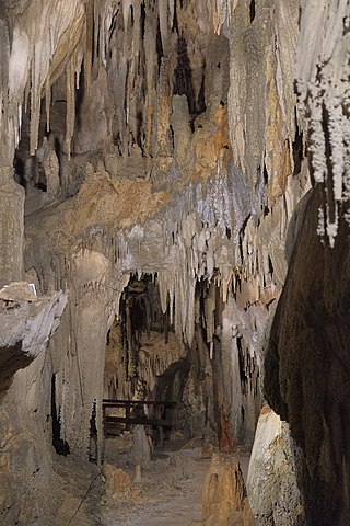
The Ngārua Caves are a series of limestone caves in the Takaka Hill range south of Abel Tasman National Park.
The Wharepapa / Arthur Range is a mountain range partially marking the boundary between the Tasman District and West Coast Region of New Zealand's South Island. The range is at the eastern extent of the Tasman Mountains which make up much of the island's northwest, making it easily visible from across the low-lying Waimea Plains further to the east. The range's location and its many uses make it a significant site for local Māori, including the iwi of Te Ātiawa and Ngāti Rārua. This includes the prominent peaks of Mount Arthur and Pukeone / Mount Campbell, which both hold mana in their own right and have become part of the identity of the aforementioned iwi.

