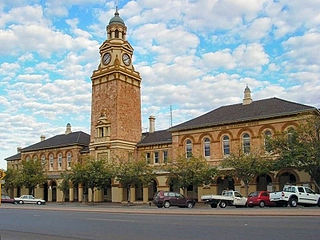
Kalgoorlie is a city in the Goldfields–Esperance region of Western Australia, located 595 km (370 mi) east-northeast of Perth at the end of the Great Eastern Highway. It is sometimes referred to as Kalgoorlie–Boulder, as the surrounding urban area includes the historic townsite of Boulder and the local government area is the City of Kalgoorlie–Boulder.

A gold rush or gold fever is a discovery of gold—sometimes accompanied by other precious metals and rare-earth minerals—that brings an onrush of miners seeking their fortune. Major gold rushes took place in the 19th century in Australia, New Zealand, Brazil, South Africa, the United States, and Canada while smaller gold rushes took place elsewhere.

Hydraulic mining is a form of mining that uses high-pressure jets of water to dislodge rock material or move sediment. In the placer mining of gold or tin, the resulting water-sediment slurry is directed through sluice boxes to remove the gold. It is also used in mining kaolin and coal.

Tasman District is a local government district in the northwest of the South Island of New Zealand. It borders the Canterbury Region, West Coast Region, Marlborough Region and Nelson City. It is administered by the Tasman District Council, a unitary authority, which sits at Richmond, with community boards serving outlying communities in Motueka and Golden Bay / Mohua. The city of Nelson has its own unitary authority separate from Tasman District, and together they comprise a single region in some contexts, but not for local government functions or resource management (planning) functions.

Cromwell is a town in Central Otago in the Otago region of New Zealand.

The Kawarau River is a river in the South Island of New Zealand. It drains Lake Wakatipu in northwestern Otago via the lake's Frankton Arm. The river flows generally eastwards for about 60 kilometres (37 mi) and passes through the steep Kawarau Gorge until it joins Lake Dunstan near Cromwell. Before the construction of the Clyde High Dam, the Kawerau joined the Clutha River / Mata-Au in a spectacular confluence at Cromwell. The Shotover River enters the Kawerau from the north; the Nevis River enters it from the south. With many rapids and strong currents, the river can be dangerous and has claimed many lives. It is popular for bungy jumping and kayaking.

Collingwood is a town in the north-west corner of the South Island of New Zealand along Golden Bay / Mohua. The town is an ecotourism destination due to its proximity to Kahurangi National Park and Farewell Spit Nature Reserve.

The Heaphy Track is a popular tramping track in the north west of the South Island of New Zealand. It is located within the Kahurangi National Park and classified as one of New Zealand's nine Great Walks by the Department of Conservation. Named after Charles Heaphy, the track is 78.4 kilometres (48.7 mi) long and is usually walked in four or five days. The track runs from Kohaihai, north of Karamea on the northern west coast of the South Island to the upper valley of the Aorere River, inland from Golden Bay.

The Otago Gold Rush was a gold rush that occurred during the 1860s in Central Otago, New Zealand. This was the country's biggest gold strike, and led to a rapid influx of foreign miners to the area - many of them veterans of other hunts for the precious metal in California and Victoria, Australia.

Lake Kaniere is a glacial lake located on the West Coast of New Zealand's South Island, nearly 200 m deep and surrounded on three sides by mountains and mature rimu forest. It is regarded by many as the most beautiful of the West Coast lakes, and is a popular tourist and leisure destination.

Lake Waikaremoana is located in Te Urewera in the North Island of New Zealand, 60 kilometres northwest of Wairoa and 80 kilometres west-southwest of Gisborne. It covers an area of 54 km2 (21 sq mi). From the Maori Waikaremoana translates as 'sea of rippling waters'.

A gold dredge is a placer mining machine that extracts gold from sand, gravel, and dirt using water and mechanical methods.

The Osceola Ditch, also known as the East Ditch, was built in 1889–1890 to convey water from Lehman Creek, Nevada to a hydraulic mine operation at Osceola. Extending for 18 mi (29 km), the ditch includes a 600 ft (180 m) tunnel as well as wooden flumes. The project also includes a rock dam and headgate on Stella Lake. The ditch's terminus at Osceola, Nevada became disused during the early 1900s and was destroyed entirely by a fire in the 1940s. Much of the East Ditch is included within Great Basin National Park.

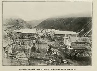
Confederate Gulch is a steeply incised gulch or valley on the west-facing slopes of the Big Belt Mountains in the U.S. state of Montana. Its small stream drains westward into Canyon Ferry Lake, on the upper Missouri River near present-day Townsend, Montana. In 1864, Confederate soldiers on parole during the American Civil War made a minor gold discovery in the gulch, but the discovery of the sensationally rich Montana Bar the following year—one of the richest placer strikes per acre ever made—led to other rich gold strikes up and down the gulch, and touched off a frantic boom period of placer gold mining in the area that extended through 1869. From 1866 to 1869, the gulch equaled or outstripped all other mining camps in the Montana Territory in gold production, producing an estimated $19–30 million worth of gold. For a time, Confederate Gulch was the largest community in Montana. In 1866, Montana had a total population of 28,000, and of these, about 10,000 (35%) were working in Confederate Gulch.

Hobson Lake is the uppermost lake on the Clearwater River in east-central British Columbia, Canada. Hobson Lake is one of the six major lakes in Wells Gray Provincial Park.

During the Australian gold rushes, starting in 1851, significant numbers of workers moved from elsewhere in Australia and overseas to where gold had been discovered. Gold had been found several times before, but the colonial government of New South Wales had suppressed the news out of the fear that it would reduce the workforce and so destabilise the economy.

Golden Bay / Mohua is a shallow, paraboloid-shaped bay in New Zealand, near the northern tip of the South Island. An arm of the Tasman Sea, the bay lies northwest of Tasman Bay / Te Tai-o-Aorere and Cook Strait. It is protected in the north by Farewell Spit, a 26 km long arm of fine golden sand that is the country's longest sandspit. The Aorere and Tākaka rivers are the major waterways to flow into the bay from the south and the west.

Parapara is a coastal locality in the Tasman District of New Zealand. It is located in Golden Bay, on the edge of the Parapara Inlet, between Tākaka and Collingwood.

Coromandel Forest Park is a protected area and conservation park administered by the Department of Conservation, covering 71,899 hectares of the Coromandel Peninsula, in the Thames Coromandel District of the Waikato Region.

Bainham is a settlement in the Tasman District of New Zealand. Originally called Riverdale, it is located in Golden Bay, 14 kilometres (8.7 mi) southwest of Collingwood.


