
The Clearwater River is on the West Coast of the South Island of New Zealand. The river originates on the northern slopes of Mount Mitchell on the western end of the Victoria Range, only one valley north of the Fox Glacier and Fox River. Clearwater River and its tributary creeks drain land to the north of the Cook River / Weheka. The river flows under a bridge of SH 6 just north of the Fox Glacier township and passes close to Lake Matheson shortly after before flowing into Cook River / Weheka, which drains into the Tasman Sea.

Paparoa National Park is on the west coast of the South Island of New Zealand.
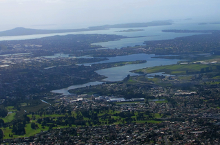
The Tāmaki River or Tāmaki Estuary is mostly an estuarial arm and harbour of the Hauraki Gulf, within the city of Auckland in New Zealand. It extends south for 15 kilometres (9 mi) from its mouth between the suburb of Saint Heliers and the long thin peninsula of Bucklands Beach, which reaches its end at Musick Point. The inlet extends past the suburbs of Glendowie, Wai o Taiki Bay, Point England, Glen Innes, Tāmaki, Panmure, and Ōtāhuhu to the west, and Bucklands Beach, Half Moon Bay, Farm Cove, Sunnyhills and Pakuranga to the east.

The New Zealand Midland Railway Company partially constructed the Midland line between Christchurch and Greymouth and the Nelson railway in the South Island. It was one of the few private railway companies in New Zealand, and it did not match the success of the Wellington and Manawatu Railway Company.

The Seddonville Branch, later truncated as the Ngākawau Branch, is a branch line railway in the West Coast region of New Zealand's South Island. Construction began in 1874 and it reached its terminus at the Mokihinui Mine just beyond Seddonville in 1895. In 1981 it was closed past Ngākawau and effectively became an extension of the Stillwater–Westport Line, since formalised as the Stillwater–Ngākawau Line.
Granity Pass lies in the Marino Mountains, within Kahurangi National Park, in New Zealand's South Island. It is located 5 km northeast of Mount Owen.
The Conns Creek Branch was a 2.7 kilometre branch line railway in the West Coast region of New Zealand's South Island. It diverged from the Seddonville Branch at Waimangaroa and followed the southern bank of the Waimangaroa River to the line's terminus at Conns Creek at the foot of the Denniston Incline. The line operated from 1877 until 1967 and existed for the sole purpose of conveying coal from mines to the port of Westport.
The Motupipi River is a short river of the Tasman Region of the South Island of New Zealand. Located in the Tākaka valley in Golden Bay, it used to be the most polluted river in the Tasman Region. Significant stream regeneration work has been underway since the early 2000s.

The Waitangitāhuna River are two rivers in the West Coast region of New Zealand's South Island. It was a single river until an avulsion in March 1967, when it became two rivers. Since then, the southern portion of the river has flowed into Lake Wahapo, while the northern section discharges into the Tasman Sea north of Ōkārito Lagoon.

Little Wanganui is a dairy-farming village on the West Coast of the South Island of New Zealand, on the Little Wanganui River. It is 77 kilometres (48 mi) north of Westport and 21 kilometres (13 mi) south of Karamea, at the opposite end of the Karamea Beach. The settlement has a pub, community hall, and volunteer fire brigade, and in 2013 the population was 207. There is a surfing beach, and the Little Wanganui River is popular for whitebaiting and fishing for brown trout.
Tataraimaka is a rural coastal area in Taranaki, New Zealand. It is predominantly a dairy farming area, approximately 20 kilometres (12 mi) south-west of New Plymouth. Tataraimaka is located south of Ōakura and north of Ōkato. The Timaru River passes through Tataraimaka on its way from Mount Taranaki. The area lies close to the Kaitake ranges at the foot of mount Taranaki, and consists of steep farmlands which overlook rolling pastures, intercepted by many creeks and rivers leading to the rocky, west coast shoreline. The area is well known for its beaches. Weld Road Beach is a popular surf beach with the locals. The area is becoming increasingly popular for people building lifestyle properties. There are many hiking tracks available to the public which traverse the Kaitake Range. One of these treks is the Boars Head Mine track, which takes hikers to a historical gold mine.

Eyre Creek is a locality in Southland, New Zealand, situated to the north-east of the Five Rivers Plain. It lies on State Highway 6, 18 km north of Lumsden. On its northern side is the Jollies Hill Pass, commonly known as the Jollies, which skirts the western flank of the Mid Dome.

Tauparikākā Marine Reserve is a marine reserve located offshore about 20 kilometres (12 mi) north of Haast on the West Coast of New Zealand's South Island. It covers the area immediately offshore from Ship Creek, which is also known as Tauparikākā in Māori.
The Ōpanuku Stream, formerly known as the Henderson Stream, is a stream of the Auckland Region of New Zealand's North Island. It flows east from its source the Waitākere Ranges through the Henderson Valley, then north-east through West Auckland before entering into the Te Wai-o-Pareira / Henderson Creek, which flows into the western the Waitematā Harbour. The stream passes through the rural locality of Henderson Valley and the West Auckland suburbs of Western Heights and Henderson. Since the mid-2000s it has been forested with native flora.

The Swanson Stream is a stream of the Auckland Region of New Zealand's North Island. It flows north-east from its source the Waitākere Ranges through rural West Auckland towards the suburb of Swanson, into the Huruhuru Creek which exits into Te Wai-o-Pareira / Henderson Creek and the western the Waitematā Harbour. Since the mid-2000s, the stream has been forested with native flora.

The Waitakere / Nile River is a river on the West Coast of New Zealand's South Island. It rises in the Paparoa Range and flows through a limestome karst landscape in a roughly northwest direction for its entire length, reaching the Tasman Sea just north of Charleston. The river and its surrounds are a popular tourist destination, particularly for a bush train along the river's canyon and caving through the nearby Metro / Te Ananui Caves. The lower reaches of the river are also a popular fishing spot, particularly for brown trout.

The Wangapeka Track is a tramping track in the north-west of the South Island of New Zealand. It is one of the main tramping tracks in the Kahurangi National Park, a protected area managed by the Department of Conservation. The route traverses the southern end of the park, from the historic Wangapeka goldfields area west of Tapawera, to the coastal plains of the West Coast at Little Wanganui. The route is 59 km (37 mi) long, and crosses the Wangapeka and Little Wanganui saddles, each over 1,000 m (3,300 ft) in elevation. The track passes through the valleys of the Wangapeka River, Karamea River, Taipō River and Little Wanganui River. The majority of the track is in river valleys and under forest cover, with small sections in tussock land at Stag Flat and the Little Wanganui Saddle. It typically takes walkers 4–6 days to complete the route.

Ship Creek is a small river that flows into an area of coastal swamp forest on the West Coast of New Zealand's South Island. Ship Creek is approximately 11 km (6.8 mi) long and flows northwest from catchment areas on the slopes of Bald Hill, reaching the Tasman Sea around 20 km (12 mi) north-east of Haast. Near the mouth of Ship Creek, there are short walks around dune lakes and ancient kahikatea swamp forest.


