
Nelson Lakes National Park is in the South Island of New Zealand, at the northern end of the Southern Alps. It was created in 1956. The park contains beech forests, multiple lakes, snow-covered mountains and valleys created by glaciers during the ice ages.

Kahurangi National Park in the northwest of the South Island of New Zealand is the second largest of the thirteen national parks of New Zealand. It was gazetted in 1996 and covers 5,193 km2 (2,005 sq mi), ranging from the Buller River near Murchison in the south, to the base of Farewell Spit in Golden Bay in the north. The park has no single dominant landform, but includes an unusually wide variety of landscapes, including mountain ranges, rivers, gorges, raised peneplains and karst features such as caves and arches. Many of the landforms within the park are considered to be nationally or internationally significant.

Arthur's Pass National Park is located in the South Island of New Zealand and covers 1,185 km2 of mostly mountainous terrain. Adjacent to it lies Craigieburn Forest Park. The park is administered by the Department of Conservation.

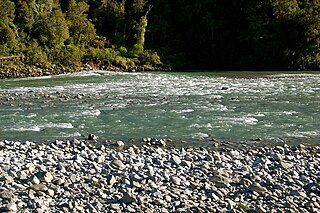
The Heaphy Track is a popular tramping and mountain biking track in the north west of the South Island of New Zealand. It is located within the Kahurangi National Park and classified as one of New Zealand's ten Great Walks by the Department of Conservation. Named after Charles Heaphy, the track is 78.4 kilometres (48.7 mi) long and is usually walked in four or five days. The track is open for shared use with mountain bikers in the winter season from 1 May to 30 September each year. The southern end of the track is at Kōhaihai, north of Karamea on the northern West Coast, and the northern end is in the upper valley of the Aorere River, Golden Bay.

Lake Ōhau is a lake in the Mackenzie Basin in the South Island of New Zealand. The Hopkins and Dobson rivers fed into the northern end of Lake Ōhau. These rivers have their headwaters in the Southern Alps. The lake's outflow is the Ōhau River, which travels from the southeast corner of Lake Ōhau and feeds into the Waitaki River hydroelectric project. The Barrier range dominate the western side of Lake Ōhau, while the Ben Ohau range dominates the eastern side of Lake Ōhau. At the northern end of the lake, in between the Hopkins and Dobson rivers, lies the Naumann Range of mountains.

Tākaka is a small town situated at the southeastern end of Golden Bay, at the northern end of New Zealand's South Island, located on the lower reaches of the Tākaka River. State Highway 60 runs through Takaka and follows the river valley before climbing over Tākaka Hill, to Motueka linking Golden Bay with the more populated coast of Tasman Bay to the southeast. The town is served by Tākaka Aerodrome.

Te Araroa is New Zealand's long distance tramping route, stretching circa 3,000 kilometres (1,900 mi) along the length of the country's two main islands from Cape Reinga to Bluff. Officially opened in 2011, it is made up of a mixture of previously made tracks and walkways, new tracks, and link sections alongside roads. Tramping the full length of the trail generally takes three to six months.

Te Waikoropupū Springs, also known as Pupu Springs and Waikaremumu Springs, are located in Golden Bay, in New Zealand's South Island. The springs are known for the clarity of the water, and the volume of water discharged. The springs are spiritually significant to Māori people. The springs feed Te Waikoropupū River, a short tributary of the Tākaka River.
The Mōkihinui River is a river located on the West Coast of New Zealand's South Island, about 40 kilometres north of Westport. Meridian Energy had proposed the Mokihinui Hydro project on the river in 2007 but it was cancelled in May 2012. In 2019, it was announced that 64,400 ha of land in the Mōkihinui River catchment, including 15 km (9.3 mi) of river bed, would be added to Kahurangi National Park.

The Matiri Project is a run-of-river hydroelectric scheme at Lake Matiri and the Matiri River in the South Island of New Zealand. The project takes water from a series of intake weirs at Lake Matiri and pipes it through a 2.4km long buried pipeline to a power station.
New Zealand Energy is a New Zealand electricity generation energy retailer company, servicing the Nelson and Tasman Regions of the country.

The Cobb Power Station is a hydroelectric facility on the Cobb River, in the Tasman District of New Zealand. The power station is located in Upper Tākaka, 112 km (70 mi) northwest of Nelson. Annual generation is approximately 190 gigawatt-hours (680 TJ). The initial stages of the construction of the station began as a privately-funded scheme in 1935, but the investor failed to raise the necessary capital. The national government took over building the station and the first power was produced in 1944, operating as a run-of-river station. A storage dam was completed in 1954. The resulting hydro lake is the highest in the country and at 596 m (1,955 ft), the station has New Zealand's highest hydraulic head of any power station.
The Motupipi River is a short river of the Tasman Region of the South Island of New Zealand. Located in the Tākaka valley in Golden Bay, it used to be the most polluted river in the Tasman Region. Significant stream regeneration work has been underway since the early 2000s.

Te Waikoropupū River, previously known as the Waikoropupū River, is a river of the Tasman Region of New Zealand's South Island. It originates in the Kahurangi National Park and flows generally northeast to reach the Tākaka River close to the town of Tākaka. On its way it passes close to the Te Waikoropupū Springs, which drain into the river and add significantly to its water volume.
The Stanley River is a river of the Tasman Region of New Zealand's South Island. It flows southeast from its sources in the Douglas and Anatoki Ranges, reaching the Waingaro River 12 kilometres west of Upper Takaka.

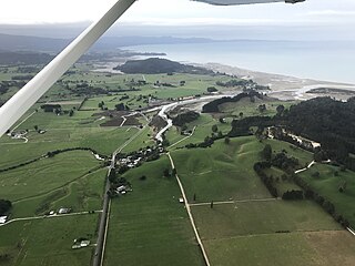
Golden Bay is a large shallow bay in New Zealand's Tasman District, near the northern tip of the South Island. An arm of the Tasman Sea, the bay lies northwest of Tasman Bay and Cook Strait. It is protected in the north by Farewell Spit, a 26 km long arm of fine golden sand that is the country's longest sandspit. The Aorere and Tākaka rivers are the major waterways to flow into the bay from the south and the west.

The Cobb Reservoir is a hydro storage lake fed by the Cobb River in the Tasman District of the South Island of New Zealand. The reservoir feeds the Cobb Power Station and is 819 metres (2,687 ft) above sea level but drops significantly with low rainfall. Cobb Reservoir is the highest hydro storage lake in New Zealand, and is entirely surrounded by Kahurangi National Park.

The Wangapeka Track is a tramping track in the north-west of the South Island of New Zealand. It is one of the main tramping tracks in the Kahurangi National Park, a protected area managed by the Department of Conservation. The route traverses the southern end of the park, from the historic Wangapeka goldfields area west of Tapawera, to the coastal plains of the West Coast at Little Wanganui. The route is 59 km (37 mi) long, and crosses the Wangapeka and Little Wanganui saddles, each over 1,000 m (3,300 ft) in elevation. The track passes through the valleys of the Wangapeka River, Karamea River, Taipō River and Little Wanganui River. The majority of the track is in river valleys and under forest cover, with small sections in tussock land at Stag Flat and the Little Wanganui Saddle. It typically takes walkers 4–6 days to complete the route.
The Wharepapa / Arthur Range is a mountain range partially marking the boundary between the Tasman District and West Coast Region of New Zealand's South Island. The range is at the eastern extent of the Tasman Mountains which make up much of the island's northwest, making it easily visible from across the low-lying Waimea Plains further to the east. The range's location and its many uses make it a significant site for local Māori, including the iwi of Te Ātiawa and Ngāti Rārua. This includes the prominent peaks of Mount Arthur and Pukeone / Mount Campbell, which both hold mana in their own right and have become part of the identity of the aforementioned iwi.
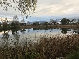
Lake Killarney is a small lake in New Zealand's South Island. It is in Tākaka just off State Highway 60. Previously used for swimming, it is now polluted due to nutrient runoff. Efforts are underway to improve water quality.


