
Tasman District is a local government district in the northwest of the South Island of New Zealand. It borders the Canterbury Region, West Coast Region, Marlborough Region and Nelson City. It is administered by the Tasman District Council, a unitary authority, which sits at Richmond, with community boards serving outlying communities in Motueka and Golden Bay / Mohua. The city of Nelson has its own unitary authority separate from Tasman District, and together they comprise a single region in some contexts, but not for local government functions or resource management (planning) functions.

Abel Tasman National Park is a national park at the north end of New Zealand's South Island. It covers 237.1 km2 (91.5 sq mi) of land between Golden Bay / Mohua and Tasman Bay / Te Tai-o-Aorere, making it the smallest of New Zealand's national parks. Despite this, the park is one of the most visited, partially due to the popularity of the Abel Tasman Coast Track which spans 60 km (37 mi) along the eastern and northern coastal areas of the park.

Collingwood is a town in the north-west corner of the South Island of New Zealand along Golden Bay / Mohua. The town is an ecotourism destination due to its proximity to Kahurangi National Park and Farewell Spit Nature Reserve.

Moturoa / Rabbit Island is a small island that lies across the southernmost part of Tasman Bay / Te Tai-o-Aorere, on the northern coast of New Zealand's South Island. The long narrow island runs east–west for 8 kilometres (5 mi), and covers 15 km2 (5.8 sq mi).

The Paparoa Range is a mountain range in the West Coast region of New Zealand's South Island. It was the first New Zealand land seen by a European – Abel Tasman in 1642. Part of the range has the country's highest protection as a national park; the Paparoa National Park was established in 1987. Within that park, the Cave Creek disaster occurred in 1995.
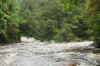
The Little Boulder River is a river of the Tasman Region of New Zealand's South Island. It flows from its sources within Kahurangi National Park to reach the Aorere River south of Collingwood.
The Little Slate River is a river of New Zealand's Tasman Region. As with its neighbour, the Slate River, it is a tributary of the Aorere River. The Little Slate meets the Aorere 15 kilometres southwest of Collingwood.

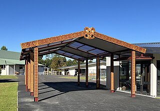
Andrew James Richmond was a 19th-century Member of Parliament in Golden Bay / Mohua and Nelson, New Zealand.

Golden Bay / Mohua is a large shallow bay in New Zealand's Tasman District, near the northern tip of the South Island. An arm of the Tasman Sea, the bay lies northwest of Tasman Bay / Te Tai-o-Aorere and Cook Strait. It is protected in the north by Farewell Spit, a 26 km long arm of fine golden sand that is the country's longest sandspit. The Aorere and Tākaka rivers are the major waterways to flow into the bay from the south and the west.
Collingwood Area School is an area school in the Golden Bay / Mohua town of Collingwood in New Zealand. The school dates back to 1859, when it was founded as Collingwood School. It was known as Collingwood District High School from 1937 to 1978.

Parapara is a coastal location in the Tasman District of New Zealand. It is located near Golden Bay, close to the edge of the Parapara Inlet, between Tākaka and Collingwood.
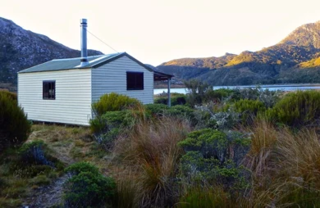
Boulder Lake is a lake in the Tasman District of New Zealand located within Kahurangi National Park. In the late 1890s and early 1900s, water from the lake was used for gold mining purposes for which the lake level was raised by a low dam. British investors lost much money with the venture and large scale mining stopped in 1905 when a flood took out part of the flume. The dam was blown up in the 1930s by a farmer disgruntled with depression-era gold miners stealing his sheep. Boulder Lake is today a tramping destination, with the Department of Conservation maintaining both a hut at the lake and a track to the lake.

The Butler Range, also known as North Butler Range, is a range located in the Westland District of the West Coast Region on the South Island of New Zealand. The range has also been known as Peaks of the Mist Range.

The Abel Tasman Monument is a memorial to the first recorded contact between Europeans—led by the Dutch explorer Abel Tasman—and Māori in New Zealand's Golden Bay on 18 and 19 December 1642. It was unveiled on the tercentenary of the encounter by the prime minister, several government ministers, and a Dutch delegation. The monument, originally referred to as the Abel Tasman Memorial, was designed by the architect Ernst Plischke as an abstracted sail, and consists of a large concrete monolith painted white. Located on a bluff at Tarakohe just east of Pōhara, the land for the monument was gifted by the Golden Bay Cement Company. The dignitaries opened the Abel Tasman National Park the following day and the area holding the monument is part of the national park. As was typical for the 1940s, the original inscription focused on the European experience only and overlooked the Māori perspective, demonstrating Western-centric systemic bias. The monument is one of New Zealand's National Memorials.

Tarakohe, in older sources referred to as Terekohe, is a locality in the Tasman District of New Zealand's upper South Island, located east of Pōhara in Golden Bay.

Bainham is a settlement in the Tasman District of New Zealand. Originally called Riverdale, it is located inland from Golden Bay, 14 kilometres (8.7 mi) southwest of Collingwood.
The Wharepapa / Arthur Range is a mountain range partially marking the boundary between the Tasman District and West Coast Region of New Zealand's South Island. The range is at the eastern extent of the Tasman Mountains which make up much of the island's northwest, making it easily visible from across the low-lying Waimea Plains further to the east. The range's location and its many uses make it a significant site for local Māori, including the iwi of Te Ātiawa and Ngāti Rārua. This includes the prominent peaks of Mount Arthur and Pukeone / Mount Campbell, which both hold mana in their own right and have become part of the identity of the aforementioned iwi.
The Kaituna River is a river in Tasman District's Golden Bay / Mohua, New Zealand.

Druggans Dam, for some time known as Toi Toi Flat Dam, is a reservoir in the Tasman District of the South Island of New Zealand. It was built to get water for gold-mining purposes.

Brown River is a river in Tasman, New Zealand.


