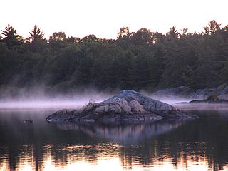
An inlet is an indentation of a shoreline, usually long and narrow, such as a small bay or arm, that often leads to an enclosed body of salt water, such as a sound, bay, lagoon, or marsh.

Tasman District is a local government district in the northwest of the South Island of New Zealand. It borders the Canterbury Region, West Coast Region, Marlborough Region and Nelson City. It is administered by the Tasman District Council, a unitary authority, which sits at Richmond, with community boards serving outlying communities in Motueka and Golden Bay / Mohua. The city of Nelson has its own unitary authority separate from Tasman District, and together they comprise a single region in some contexts, but not for local government functions or resource management (planning) functions.

The Archipelago is a township in central Ontario, Canada, along the Georgian Bay in the District of Parry Sound.
Waimea is a common place name in Hawaii and New Zealand. In Hawaiian, it means reddish water; in Māori it means forgotten or hidden stream. It may refer to:

The Wai-iti River is in the north of the South Island of New Zealand. It flows northeast for 45 kilometres (28 mi) before combining with the Wairoa River to form the Waimea River. This flows into the southern end of Tasman Bay / Te Tai-o-Aorere near Richmond.

Tasman Bay / Te Tai-o-Aorere, originally known as Blind Bay, is a large V-shaped bay at the north end of New Zealand's South Island. Located in the centre of the island's northern coast, it stretches along 120 kilometres (75 mi) of coastline and is 70 kilometres (43 mi) across at its widest point. It is an arm of the Tasman Sea, lying on the western approach to Cook Strait.
The Waimea River is located in the north of the South Island of New Zealand. It is formed from the confluence of the Wairoa River and the Wai-iti River, which meet near Brightwater. The combined waters flow into Tasman Bay / Te Tai-o-Aorere near Appleby, opposite Rabbit Island.
The Diocese of Nelson is one of the 13 dioceses and hui amorangi of the Anglican Church in Aotearoa, New Zealand and Polynesia. The Diocese covers the northern part of the South Island of New Zealand, which is mostly the area north of a line drawn from Greymouth to Kaikoura.

Popponesset Bay System is a group of bays located at the towns of Mashpee and Barnstable (east), on Cape Cod, Massachusetts with a southern shore bounded by water from Nantucket Sound.

The Wairoa River is located in the north of the South Island of New Zealand. It flows north for 45 kilometres before combining with the Wai-iti River to form the Waimea River. This flows into the southern end of Tasman Bay / Te Tai-o-Aorere near Richmond.

Penzance Bay is a popular bay located in Tennyson Inlet, within the Marlborough Sounds. Tennyson Inlet is an arm of Pelorus Sound. The bay is immediately north of Tuna Bay which is accessed by the same road.
Massacre Bay is an inlet on the southeast coast of the island of Attu in the Aleutian Islands in Alaska. Massacre Bay was among the landing sites of United States Army troops in the Battle of Attu in May 1943, which led to the recapture of the island from the Japanese during World War II.
Holtz Bay is an inlet on the northeast coast of the island of Attu in the Aleutian Islands in Alaska.
The Moutere River is a river of the Tasman Region of New Zealand's South Island. It flows north from its origins southwest of Mapua, reaching Tasman Bay / Te Tai-o-Aorere at the Moutere Inlet, a tidal lagoon three kilometres south of Motueka.

State Highway 60 is a state highway servicing the far northwest of the South Island of New Zealand. Running between the settlements of Richmond and Collingwood, it is 116 kilometres (72 mi) long and lies entirely within the Tasman District. It is the northernmost highway in the South Island and is a popular tourist route, servicing Motueka, Abel Tasman National Park, Golden Bay, and Farewell Spit.
The Waimea Plains is a small but fertile area of low-lying land south of the port city of Nelson, situated on Tasman Bay / Te Tai-o-Aorere in the South Island of New Zealand. It is irrigated by the Waimea River from the Waimea Inlet in the north and bounded by the town of Brightwater in the south. The fertile soil promotes the growth of kiwifruit, apples and vineyards.

Appleby is a locality in the Tasman district in the South Island of New Zealand. It is located around the Waimea River near the Tasman Bay / Te Tai-o-Aorere. It was first settled in the early 1840s. State Highway 60 passes through the settlement.
Bell Island may refer to:
Croisilles Harbour is a natural inlet north of Nelson at the westernmost edge of the Marlborough Sounds on the northern coast of New Zealand's South Island. It has two major arms, Okiwi Bay and Squally Cove.
Tasman is a settlement in the Tasman District of New Zealand's upper South Island. It is located between Mapua and Motueka, 45 kilometres (28 mi) from Abel Tasman National Park and 40 kilometres (25 mi) from Nelson.
This page is based on this
Wikipedia article Text is available under the
CC BY-SA 4.0 license; additional terms may apply.
Images, videos and audio are available under their respective licenses.


