
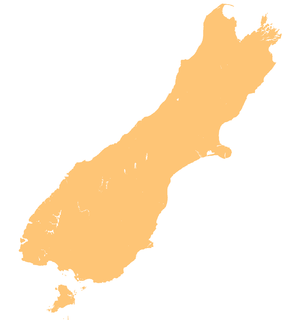
The D'Urville River is in the South Island of New Zealand.

The town of Motueka in the South Island of New Zealand lies close to the mouth of the Motueka River, on the western shore of Tasman Bay. It is, after Richmond, the second largest centre in the Tasman Region, with a population of 7125. The Motueka Ward had an estimated population of 10,900 at 30 June 2009.
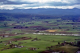
The Motueka River is located in the north of the South Island of New Zealand and is a popular tourist destination for watersports and fishing. The Motueka flows 116 kilometres (72 mi) from the mountains 40 km west of the city of Nelson in the southeast of the catchment and flows north to the Tasman Bay.
Tapawera is a hamlet in New Zealand's South Island. It is located 30 kilometres southwest of Nelson by the banks of the Motueka River. The population including the surrounding area was 405 in the 2006 Census, an increase of 21 from 2001. The town is a gateway to the Kahurangi National Park.

Tasman Bay / Te Tai-o-Aorere, originally known as Blind Bay, is a large V-shaped bay at the north end of New Zealand's South Island. Located in the centre of the island's northern coast, it stretches along 120 kilometres (75 mi) of coastline and is 70 kilometres (43 mi) across at its widest point. It is an arm of the Tasman Sea, lying on the western approach to Cook Strait.
Arapito is a town in the Karamea area of New Zealand. Arapito is a farming community on the south side of the Karamea River, and upriver from the main Karamea township.
The Baton River is a river in the Tasman District of the South Island of New Zealand. It rises near the Baton Saddle in the Arthur Range and flows ESE then northeast before feeding into the Motueka River 2 kilometres (1.2 mi) south of Woodstock. A tramping track follows the upper part of the river valley, leading to the Karamea-Leslie track and Kahurangi National Park.
The Little Pokororo River is a river of the Tasman Region of New Zealand's South Island. Like its neighbour the Pokororo River it is a tributary of the Motueka River, which it meets 15 kilometres southwest of Motueka.
The Motupiko River is a river of the Tasman Region of New Zealand's South Island. A major tributary of the Motueka River, it flows north from its origins southeast of the Hope Saddle, meeting the Motueka at Kohatu Junction, 15 kilometres west of Wakefield. The Motupiko's tributaries include the Rainy River.

The Pearse River is a river of the Tasman Region of New Zealand's South Island. It flows east from sources in the Arthur Range, reaching the Motueka River 20 kilometres southwest of Motueka.
The Pokororo River is a river of the Tasman Region of New Zealand's South Island. It flows southeast from the Arthur Range to reach the Motueka River 15 kilometres southwest of the town of Motueka.
The Sherry River is a river in New Zealand's Tasman Region. It flows north from its origins in the Hope Range to meet the Wangapeka River eight kilometres from the latter's outflow into the Motueka River.
The Tadmor River is a river of the Tasman Region of New Zealand's South Island. It flows generally north from its sources in the Hope Range to reach the Motueka River three kilometres northwest of Tapawera.
The Wangapeka River is a river of the Tasman Region of New Zealand's South Island. It rises in two branches, the North Branch and the South Branch, in the Matiri Range within Kahurangi National Park, meeting some 25 kilometres southeast of Karamea. It flows generally northeast to reach the Motueka River 30 kilometres south of Motueka.
The Eyre River is a river in the Canterbury region of New Zealand. It arises in the Puketeraki Range and flows south-east into the Waimakariri River near Christchurch International Airport. The connection with the Waimakariri is via a diversion channel running south-west, replacing the Eyre's original easterly flow. The river is named after Edward John Eyre, the Lieutenant-Governor of New Munster from 1848–53.
The Dove River is a river in the Tasman Region of New Zealand. It arises in hills between the Wai-iti River and Motueka River and flows north-west into the Motueka near the locality of Woodstock. The river is named for the native New Zealand pigeons once found in the forests around the river.
The Dart River arises in the Kahurangi National Park between the Lookout and Hope Ranges in the Tasman Region of New Zealand. It flows northward to join the Wangapeka River, which is a tributary of the Motueka River.
The Rainy River is a river of the southern Tasman Region of New Zealand's South Island. It flows north from its sources 2 kilometres (1.2 mi) north of Saint Arnaud, reaching the Motupiko River 6 kilometres (3.7 mi) east of the Hope Saddle. The Motupiko River is a tributary of the Motueka River
State Highway 61 (SH 61) is a former New Zealand state highway in the Tasman Region of the South Island. It links the coastal town of Motueka with SH 6, the main route to the South Island's West Coast. Along with several other state highways, its status was revoked at the beginning of the 1990s. The route is now usually referred to as the Motueka Valley Highway.


