Motueka is a town in the South Island of New Zealand, close to the mouth of the Motueka River on the western shore of Tasman Bay. It is the second largest in the Tasman Region, with a population of 8,300 as of June 2024.[3]
The surrounding district has a number of apple, pear, and kiwifruitorchards, as well as growing a variety of specialised crops such as hops. The area formerly served as the main centre of tobacco growing in New Zealand until the early 1980s.[4] A number of small vineyards have also been developed.
Nearby beaches (such as Kaiteriteri and Mārahau) are very popular with holidaymakers, and the area around Motueka has one of the country's highest annual sunshine-hour indices.[5]Riwaka lies 4.8km north of Motueka via State Highway 60 and Nelson is 41.7km to the east of Motueka via State Highway 60 and State Highway 6.
The name Motueka, or more correctly Motuweka, comes from the Māori language, and means weka island, the weka being a bird of the rail family. The town is colloquially called "Mot" by some residents.[citation needed]
History
The Motueka District Museum
The first known European visitor to the coast near Motueka in 1827 was French explorer Jules Dumont d'Urville, of the French corvette Astrolabe. He explored and described much of the Tasman Bay shore line. Three ships carrying the New Zealand Company's Nelson expedition, led by Captain Arthur Wakefield, anchored at Astrolabe Roads, north of Kaiteriteri Beach—about 16 kilometres (10mi) due north of Motueka—in October 1841. Kaiteriteri was selected as a site for the first settlement but was later abandoned in favour of Nelson Haven.
The exceptional fertility of the soil and the suitability of the surrounding land for small farm settlement were the main reasons for the establishment of the second town of the Nelson settlement at Motueka in 1842. There was trade between Nelson and Motueka in vegetables and timber in the 1840s. In 1850, Motueka had "a church, various tradespeople, a general store, a doctor, a clergyman, a magistrate and a constable". Motueka was described as "the village was laid out in small sections in the middle of a splendid bush, and had some good open land all around on which the farms were situated” in the 1850s.[7] A significant flood hit Motueka in 1877 with the majority of buildings in the High Street being flooded.[7]
During the period, 1853 to 1876, Motueka was administrated as part of the Nelson Province.
Motueka was created as a borough in 1900 with the first meeting of the Motueka Borough Council being held on 17 January 1900.[8] The population at that time was 900 people with 182 ratepayers and 183 dwellings.[9] The post office building was opened in 1902 by Sir Joseph Ward.[9]
Motueka war memorial, Motueka
The Motueka war memorial was unveiled in 1922. It commemorates the 32 soldiers who died in WWI from the Motueka district. A plaque on the war memorial was unveiled in 1957 to commemorate the 35 soldiers who died in WWII from the Motueka district.[10]
Demographics
The population of Motueka in 1951 was 2464 people which increased to 2824 people in 1956 and 3310 people in 1961.[11]
Motueka covers 12.68km2 (4.90sqmi)[2] and had an estimated population of 8,300 as of June 2024,[3] with a population density of 655 people per km2.
Before the 2023 census, the town had a larger boundary, covering 13.66km2 (5.27sqmi).[2] Using that boundary, Motueka had a population of 8,007 at the 2018 New Zealand census, an increase of 897 people (12.6%) since the 2013 census, and an increase of 1,383 people (20.9%) since the 2006 census. There were 2,976 households, comprising 3,885 males and 4,128 females, giving a sex ratio of 0.94 males per female, with 1,323 people (16.5%) aged under 15 years, 1,314 (16.4%) aged 15 to 29, 3,189 (39.8%) aged 30 to 64, and 2,181 (27.2%) aged 65 or older.
Ethnicities were 85.8% European/Pākehā, 14.6% Māori, 2.5% Pasifika, 5.7% Asian, and 2.3% other ethnicities. People may identify with more than one ethnicity.
The percentage of people born overseas was 18.3, compared with 27.1% nationally.
Although some people chose not to answer the census's question about religious affiliation, 53.8% had no religion, 33.3% were Christian, 0.9% had Māori religious beliefs, 0.5% were Hindu, 0.1% were Muslim, 1.7% were Buddhist and 2.1% had other religions.
Of those at least 15 years old, 786 (11.8%) people had a bachelor's or higher degree, and 1,659 (24.8%) people had no formal qualifications. 489 people (7.3%) earned over $70,000 compared to 17.2% nationally. The employment status of those at least 15 was that 2,835 (42.4%) people were employed full-time, 1,008 (15.1%) were part-time, and 174 (2.6%) were unemployed.[12]
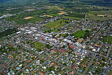
Motueka looking toward the south-west and the airport
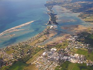
Motueka is situated on the small Motueka Plain near the Motueka River which enters Tasman Bay about 4km north of the town. To the west of the valley the land rises steeply to the Arthur and Pikiruna Ranges, and to the south the flat is broken by the gently rolling Moutere Hills.
St Thomas's Anglican church, located at 101 High street, was listed as a category two historic place in 1982. It was built in 1911.[19]
Former Catholic church
The former Motueka Catholic church (2023)
The former Catholic church, located at 31 High street, was listed as a category two historic place in 1982. St Peters Chanel church was consecrated in 1917 and was built out of marble from Tākaka. In 1985, the church was replaced by a larger church for the congregation.[20][21]
St Andrew's church
St Andrew's Church, Motueka (2023)
St Andrew's church, located at 64 High street, was listed as a category two historic place in 1982.[22]
The Motueka district museum is located in the former Motueka district high school buildings (built 1913) at 140 High Street. The museum includes exhibitions on local history.[26]
Library
The Motueka library is located at 32 Wallace Street.[27] It was rebuilt in 2022 and cost just over $4.92 million. It is over twice the size of the previous library on Pah St.[28]
Saltwater pool
Motueka is home to a saltwater pool which is located on the Motueka foreshore. It was originally built after a sighting of a shark in the 1920s. Originally a wire cage, in 1938, it was rebuilt as a pool and then upgraded in 1950 and 1992.[29][30]
Golf course
The Motueka golf club was awarded the Holden New Zealand golf club of the year in 2018. It is located on Harbour Road in Motueka.[31][32]
Motueka recreation centre
The Motueka recreation centre includes a stadium, climbing wall, a fitness lounge, a theatre facility, games room, a skating rink and netball courts. It is operated by Sport Tasman and is located at 40 Old Wharf Road.[33] The climbing wall was refurbished in 2016.[34]
Economy
Talley's Seafood Division at Port Motueka
Horticulture is the main industry in the area surrounding Motueka, and the town benefits directly from this. Some of the main crops are apples, beer hops and kiwifruit. Sheep and cattle farming also contribute to the local economy.[35]
Due to the seasonal growth of many crops, the town's population increases greatly with seasonal workers, especially during late summer and early autumn for the apple 'pick'.
At the height of tobacco production, Motueka was home to two tobacco factories. One owned by Australian company WD & HO Wills Holdings and the other by Rothmans International. The tobacco industry has ceased to exist in the area in the early 1980s, when the New Zealand government removed the requirement for some New Zealand grown tobacco to be included in locally produced cigarettes.[4]
Major employers in Motueka include:
Genia (formally MLC Group), operates a timber processing facility that specialises in cut-to-length componentry, small end section and specialised timber mouldings.
Prolam has manufacturing facilities in Lower Moutere and Riwaka (previously Prime Pine) that produce glulam beams, i beams, LVL timber, posts, wood flooring, timber retaining walls and mid floors.
Talley's Group was established in 1936 by Ivan Peter Talijancich. One of the town's largest employers, the company's Port Motueka site incorporates the Group Head Office, the Seafood Division and the Dairy Division. The Vegetable Division began operations in 1978 at Motueka, but has since been relocated to Blenheim and Ashburton.[37] Seafood processing contributed $46.5 million (10.9%) to the local economy in 2021.[38]
CJ Industries is a construction and landscaping company.
Motueka High School is a co-educational state secondary school for Year 9 to 13 students,[69][70] with a roll of 692 as of November 2024.[71]
There are two co-educational state primary schools in the township for Year 1 to 8 students: Parklands School,[72][73] with a roll of 209,[74] and Motueka South School,[75][76] with a roll of 201.[77]
There are two private primary schools in the township for Year 1 to 8 students: Motueka Steiner School,[78][79] with a roll of 100,[80] and St Peter Chanel School,[81][82] with a roll of 64.[83]
There are also five other primary schools in the area surrounding Motueka.[84]
Media
Newspaper
There are two local newspapers in Motueka: The Guardian Motueka, out every Wednesday and The Tasman Leader, out every Thursday. The "Motueka Star" was established in August 1901, and was a six-page newspaper, published twice weekly.[9]
The former State Highway61, now known as the Motueka Valley Highway, connects State Highway 60 at Motueka to State Highway 6 at Kohatu Junction near Tapawera.
Port
Port Motueka, 3 kilometres (2mi) south-east of Motueka, on a tidal lagoon of some 1,000 hectares (2,500 acres), provides sheltered berthage for coastal vessels and is the Gateway to the Abel Tasman National Park.[citation needed]
Motueka hosts the Kaiteriteri Carnival and Motueka Festival of Lights.
Sport
Mountain biking
Motueka sits on the Tasman's Great Taste Trail which is a mountain bike trail connecting the towns of Nelson, Wakefield, Richmond, Motueka and Kaiteriteri.[89]
↑ McLintock, Alexander Hare; Brian Newton Davis, M. A.; Taonga, New Zealand Ministry for Culture and Heritage Te Manatu. "MOTUEKA". An encyclopaedia of New Zealand, edited by A. H. McLintock, 1966. Retrieved 26 January 2023.
This page is based on this Wikipedia article Text is available under the CC BY-SA 4.0 license; additional terms may apply. Images, videos and audio are available under their respective licenses.