
Lake Vyrnwy is a reservoir in Powys, Wales, built in the 1880s for Liverpool Corporation Waterworks to supply Liverpool with fresh water. It flooded the head of the Vyrnwy valley and submerged the village of Llanwddyn.

Lake Mahinerangi is a lake formed when a dam was built on the Waipori River for hydroelectric generation. The lake is 35 kilometres (22 mi) to the west of Dunedin in New Zealand's South Island. Construction of the dam started in 1903 and since 1907, power has been produced.

The Stephens Creek Dam is an earth-filled embankment dam built on a rock foundation with an uncontrolled spillway across the Stephens Creek, located in the Far West region of New South Wales, Australia. The principal purpose of the dam is to supply potable water for the town of Broken Hill. The impounded 2,000-megalitre reservoir is called Stephens Creek Reservoir.

The Yuba River is a tributary of the Feather River in the Sierra Nevada and eastern Sacramento Valley, in the U.S. state of California. The main stem of the river is about 40 miles (64 km) long, and its headwaters are split into three major forks. The Yuba River proper is formed at the North Yuba and Middle Yuba rivers' confluence, with the South Yuba joining a short distance downstream. Measured to the head of the North Yuba River, the Yuba River is just over 100 miles (160 km) long.

The Bridge River is an approximately 120 kilometres (75 mi) long river in southern British Columbia. It flows south-east from the Coast Mountains. Until 1961, it was a major tributary of the Fraser River, entering that stream about six miles upstream from the town of Lillooet; its flow, however, was near-completely diverted into Seton Lake with the completion of the Bridge River Power Project, with the water now entering the Fraser just south of Lillooet as a result.

The Gold Creek Dam is an earth-fill embankment dam with an un-gated spillway across the Gold Creek that is located in the South East region of Queensland, Australia. The main purpose of the dam is for potable water supply of the Brisbane region. The resultant reservoir is called the Gold Creek Reservoir.
Lake Manchester Dam is a concrete gravity dam with an un-gated spillway across Cabbage Tree Creek. It is also known as Cabbage Tree Creek Dam. It is in the locality of Lake Manchester, City of Brisbane, Queensland, Australia. The main purpose of the dam is for potable water supply of Brisbane. The impounded reservoir is called Lake Manchester.
The Duncan River is in the West Kootenay region of southeastern British Columbia. Entering the North Arm of Kootenay Lake, the river is a major tributary of the Kootenay River, which in turn flows into the Columbia River. The Selkirk Mountains lie to the west and the Purcell Mountains to the east.
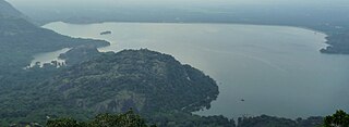
Aliyar Reservoir is a 6.48 km2 (2.5 sq mi) reservoir located in Aliyar village near Pollachi town in Coimbatore District, Tamil Nadu, South India. The dam is located in the foothills of Valparai, in the Anaimalai Hills of the Western Ghats. It is about 65 kilometres (40 mi) from Coimbatore. The dam offers some ideal getaways including a park, garden, aquarium, play area and a mini Theme-Park maintained by Tamil Nadu Fisheries Corporation for visitors enjoyment. The scenery is beautiful, with mountains surrounding three quarters of the reservoir. Boating is also available.

The Cobb Power Station is a hydroelectric facility on the Cobb River, in the Tasman District of New Zealand. The power station is located in Upper Tākaka, 112 km (70 mi) northwest of Nelson. Annual generation is approximately 190 gigawatt-hours (680 TJ). The initial stages of the construction of the station began as a privately-funded scheme in 1935, but the investor failed to raise the necessary capital. The national government took over building the station and the first power was produced in 1944, operating as a run-of-river station. A storage dam was completed in 1954. The resulting hydro lake is the highest in the country and at 596 m (1,955 ft), the station has New Zealand's highest hydraulic head of any power station.

Lake Cachi is an artificial lake in central Costa Rica created by the Cachí Dam, an arch dam north of Tapantí National Park, to the east-southeast of Cartago in Cartago Province. The main town is Cachí, away from the east bank of the lake. Built in the 1970s, it was one of the first hydroelectric projects in Costa Rica. It has an installed capacity of 102 MW with three units of 34 MW capacity each.
Kosasthalaiyar River, also known as Kortalaiyar, is one of the three rivers that flow in the Chennai metropolitan area.

Wingecarribee Dam, completed in 1974 as part of the Shoalhaven Scheme, is an earth and rockfill embankment dam structure located on the Wingecarribee River about 15 kilometres (9.3 mi) southeast of Bowral in New South Wales, Australia. The embankment of 573 cubic metres (20,200 cu ft) is 19 metres (62 ft) high and 1,140 metres (3,740 ft) in length. At 100% capacity, the dam wall holds back approximately 25,875 megalitres and creates the impounded reservoir of Wingecarribee Reservoir that has a surface area of 625 hectares, drawn from a catchment area of 40 square kilometres (15 sq mi). The spillway has a discharge capacity of 520 cubic metres per second (18,000 cu ft/s). Wingecarribee Reservoir lost around 9,000 megalitres of storage capacity as a result of the inflow of peat from the Wingecarribee Swamp collapse in August 1998. The original storage capacity was 34,500 megalitres.

The Metro Vancouver watersheds, also known as the Greater Vancouver watersheds, supply potable water to approximately 2.7 million residents in the Lower Mainland of British Columbia. They provide tap water to a land area covering more than 2,600 square kilometres (1,000 sq mi), serving a total of 21 member municipalities, one electoral district, and one treaty First Nation. From west to east, the watersheds are the Capilano, the Seymour, and the Coquitlam. They are located in the North Shore Mountains and Coquitlam Mountain, respectively. Each watershed possesses a reservoir for water storage purposes, under the control of Metro Vancouver. The reservoirs are supplied by about 3.5 metres (11 ft) of rain and 4.5 metres (15 ft) of snowpack annually. Two additional off-catchment areas under control of Metro Vancouver contribute to the water supply. The watersheds have a long history of controversies surrounding logging, highway development, and salmon run conservation.
Collingwood Water Race is a heritage-listed aqueduct at Monkhouse Timber Reserve, Rossville, Shire of Cook, Queensland, Australia. It was built from 1902 to 1906. It is also known as Annan River Company Water Race. It was added to the Queensland Heritage Register on 13 April 2006.

The Mégiscane River is a tributary of Parent Lake (Abitibi). It flows in the Northwest of Quebec, in Canada, in the administrative regions of:

Du Poète Lake is a freshwater lake that has become the "Du Poète Reservoir", located west of the Gouin Reservoir, in the territory of the city of La Tuque, in the administrative region of Mauricie, in the province of Quebec, in Canada. This lake extends entirely in the canton of Poisson.

Parapara is a coastal location in the Tasman District of New Zealand. It is located near Golden Bay, close to the edge of the Parapara Inlet, between Tākaka and Collingwood.
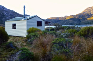
Boulder Lake is a lake in the Tasman District of New Zealand located within Kahurangi National Park. In the late 1890s and early 1900s, water from the lake was used for gold mining purposes for which the lake level was raised by a low dam. British investors lost much money with the venture and large scale mining stopped in 1905 when a flood took out part of the flume. The dam was blown up in the 1930s by a farmer disgruntled with depression-era gold miners stealing his sheep. Boulder Lake is today a tramping destination, with the Department of Conservation maintaining both a hut at the lake and a track to the lake.
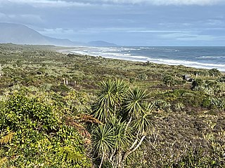
The Barrytown Flats are a 17 km (11 mi) coastal plain north of Greymouth on the West Coast of New Zealand's South Island. A series of postglacial shorelines and dunes backed by a former sea cliff, they was originally covered with wetland and lowland forest, including numerous nīkau palms. The sands were extensively sluiced and dredged for gold from the 1860s, centred on the small settlement of Barrytown. The drier areas of the flats have been converted into pasture, but significant areas of forest remain, including Nikau Scenic Reserve. The flats are bordered by Paparoa National Park and the only breeding site of the Westland petrel. There are significant deposits of ilmenite in the Barrytown sands, and there have been several mining proposals, but the possible environmental consequences have been contentious.

