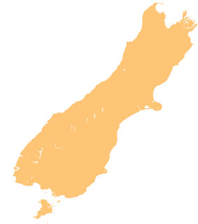
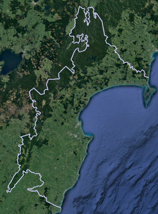
Kahurangi National Park in the northwest of the South Island of New Zealand is the second largest of the thirteen national parks of New Zealand. It was gazetted in 1996 and covers 5,193 km2 (2,005 sq mi), ranging from the Buller River near Murchison in the south, to the base of Farewell Spit in Golden Bay in the north. The park has no single dominant landform, but includes an unusually wide variety of landscapes, including mountain ranges, rivers, gorges, raised peneplains and karst features such as caves and arches. Many of the landforms within the park are considered to be nationally or internationally significant.

Abel Tasman National Park is a New Zealand national park located between Golden Bay / Mohua and Tasman Bay at the north end of the South Island. It is named after Abel Tasman, who in 1642 became the first European explorer to sight New Zealand and who anchored nearby in Golden Bay.

Kaipara Harbour is a large enclosed harbour estuary complex on the north western side of the North Island of New Zealand. The northern part of the harbour is administered by the Kaipara District and the southern part is administered by the Auckland Council. The local Māori tribe is Ngāti Whātua.

Protected areas of New Zealand are areas that are in some way protected to preserve their environmental, scientific, scenic, historical, cultural or recreational value. There are about 10,000 protected areas, covering about a third of the country. The method and aims of protection vary according to the importance of the resource and whether it is publicly or privately owned.

The Barker Inlet is a tidal inlet of the Gulf St Vincent in Adelaide, South Australia, named after Captain Collet Barker who first sighted it in 1831. It contains one of the southernmost mangrove forests in the world, a dolphin sanctuary, seagrass meadows and is an important fish and shellfish breeding ground. The inlet separates Torrens Island and Garden Island from the mainland to the east, and is characterised by a network of tidal creeks, artificially deepened channels, and wide mudflats. The extensive belt of mangroves are bordered by samphire saltmarsh flats and low-lying sand dunes.

Ngāti Rangi or Ngāti Rangituhia is a Māori iwi (tribe) of New Zealand. Contemporary settlement is mainly around Waiouru, Ohakune, and the Upper Whanganui River in the central North Island. The iwi's area of interest extends north from the Paretetaitonga peak of Mount Ruapehu, west to the Pukupuku Stream, east to the meeting of the Moawhango and Aorangi waterways, and south to the Haumakariri Stream. Ngāti Rangi trace their ancestry to Paerangi. They believe they were in New Zealand before the first migrations from Hawaiki.

Cape Rodney-Okakari Point Marine Reserve is a 5.5 km2 (2.1 sq mi) protected area in the North Island of New Zealand.

Pāuatahanui Wildlife Reserve is a wetland reserve at the eastern edge of the Pāuatahanui Inlet of the Porirua Harbour in Porirua, New Zealand. The reserve contains the most significant area of saltmarsh in the lower North Island of New Zealand. It also includes tidal mudflats, shrub lands and regenerating coastal forest. The reserve covers 50 hectares, of which the Department of Conservation owns 46 hectares, and Forest & Bird owns the remaining 4 hectares under covenant to the Queen Elizabeth II Trust. The reserve is managed by a committee of Forest & Bird representatives in association with the Department of Conservation.
Whanganui Inlet, commonly known by its former name Westhaven Inlet or West Haven, is a large natural indentation in the northwest coast of the South Island of New Zealand.

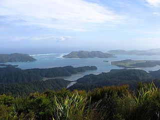
Ulva Island-Te Wharawhara Marine Reserve is a marine reserve covering an area of 1,075 hectares south-west and north-east of Ulva Island, in the Paterson Inlet of New Zealand's Stewart Island. It was established in 2004 and is administered by the Department of Conservation.

Waiau Glacier Coast Marine Reserve is a marine reserve of the West Coast Region of New Zealand's South Island. It covers an area of 4,641 hectares or 46 km2, from 11 km south from Kohuamarua Bluff near Ōkārito, to Omoeroa Bluff, and about 4 km out to sea.

The Wairarapa Moana Wetlands are a major wetland, located in the South Wairarapa District in the Wellington Region at the southern end of New Zealand's North Island.

Kahurangi Marine Reserve is a marine reserve administered by the Department of Conservation, covering 8,419 hectares offshore of Kahurangi National Park in the Buller District of New Zealand's West Coast Region.

Te Matuku Marine Reserve is a marine reserve administered by the New Zealand Department of Conservation. It includes Te Matuku Bay, one of the largest and least disturbed estuaries on Waiheke Island, as well as a surrounding area of sea. It covers an area of 690 ha and was established in 2003.
Te Matuku Bay is a bay on Waiheke Island in New Zealand's Hauraki Gulf. It is one of the largest and least disturbed estuaries on the island. Since 2003, the area has been protected as part of Te Matuku Marine Reserve.
Te Angiangi Marine Reserve is a marine reserve covering a marine area of 446 hectares in the Hawke's Bay Region of New Zealand's North Island. It was established in 1997 and is administered by the Department of Conservation.

Kutu Parera Marine Reserve is a marine reserve covering an area of 433 hectares at Gaer Arm in the Bradshaw Sound of Fiordland on New Zealand's South Island. It was established in 2005 and is administered by the Department of Conservation.

Taumoana Marine Reserve is a marine reserve covering an area of 464 hectares in Fiordland on New Zealand's South Island. It was established in 2005 and is administered by the Department of Conservation. It is located next to the Five Fingers Peninsula, at the entrance to Tamatea / Dusky Sound.
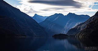
Moana Uta Marine Reserve is a marine reserve covering the entire length of Wet Jacket Arm in Fiordland on New Zealand's South Island, an area of 2,007 hectares. It was established in 2005 and is administered by the Department of Conservation.
Endeavour Inlet is a large inlet of Queen Charlotte Sound, part of New Zealand's Marlborough Sounds. It lies north-east of Bay of Many Coves / Miritū Bay and south-west of Resolution Bay. The inlet is home to a number of retreats, including Furneaux Lodge and Punga Cove.