
The South Island, also officially named Te Waipounamu, is the larger of the two major islands of New Zealand in surface area, the other being the smaller but more populous North Island. It is bordered to the north by Cook Strait, to the west by the Tasman Sea, and to the south and east by the Pacific Ocean. The South Island covers 150,437 square kilometres (58,084 sq mi), making it the world's 12th-largest island. At low altitude, it has an oceanic climate.

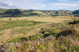
The Mackenzie Basin, popularly and traditionally known as the Mackenzie Country, is an elliptical intermontane basin located in the Mackenzie and Waitaki Districts, near the centre of the South Island of New Zealand. It is the largest such basin in New Zealand. Historically famous mainly for sheep farming, the sparsely populated area is now also a popular tourism destination.

Twizel is the largest town in the Mackenzie District, in the Canterbury Region of the South Island of New Zealand. The town was founded in 1968 to house construction workers on the Upper Waitaki Hydroelectric Scheme. Twizel has a resident population of 1,660 ; during the summer, holidaymakers nearly triple the town's population. Twizel is 37 km east of Lake Ōhau, 30 km north of Omarama and 60 km south of Lake Tekapo.

Lake Ōhau is a lake in the Mackenzie Basin in the South Island of New Zealand. The Hopkins and Dobson rivers fed into the northern end of Lake Ōhau. These rivers have their headwaters in the Southern Alps / Kā Tiritiri o te Moana. The lake's outflow is the Ōhau River, which travels from the southeast corner of Lake Ōhau and feeds into the Waitaki River hydroelectric project. The Barrier range dominate the western side of Lake Ōhau, while the Ben Ohau range dominates the eastern side of Lake Ōhau. At the northern end of the lake, in between the Hopkins and Dobson rivers, lies the Naumann Range of mountains.

Lake Pukaki is the largest of three roughly parallel alpine lakes running north–south along the northern edge of the Mackenzie Basin on New Zealand's South Island. The others are Lakes Tekapo and Ohau. All three lakes were formed when the terminal moraines of receding glaciers blocked their respective valleys, forming moraine-dammed lakes. The Alps2Ocean mountain bike trail follows the edge of Lake Pukaki for part of its length.
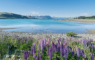
Lake Tekapo (Takapō) is the second-largest of three roughly parallel lakes running north–south along the northern edge of the Mackenzie Basin in the South Island of New Zealand. It covers an area of 83 square kilometres (32 sq mi), and is at an altitude of 710 metres (2,330 ft) above sea level.

Lake Tekapo is a small township located at the southern end of the lake of the same name in the inland South Island of New Zealand. It had 558 residents according to the 2018 census, being one of five settlements in the sparsely populated Mackenzie Basin.

Mackenzie District is a local government district in New Zealand's South Island administered by the Mackenzie District Council. It is part of the larger Canterbury region.

Regional parks of New Zealand are protected areas administered by regional councils, the top tier of local government.
Environment Canterbury, frequently abbreviated to ECan. is the promotional name for the Canterbury Regional Council. It is the regional council for Canterbury, the largest region in the South Island of New Zealand. It is part of New Zealand's structure of local government.

Wilding conifers, also known as wilding pines, are invasive trees in the high country of New Zealand. Millions of dollars are spent on controlling their spread.
Queen Elizabeth Park is a Wellington Regional Park located on the Kapiti Coast in New Zealand. The park contains the last area of natural dunes on the Kapiti Coast.
East Harbour Regional Park is a regional park stretching from Baring Head along the east side of the Wellington Harbour along the east side of Eastbourne. It is located in Lower Hutt City, in the Wellington Region of New Zealand's North Island.

Kaitoke Regional Park is regional park located at Kaitoke, northeast of Upper Hutt, in the Wellington Region of New Zealand's southern North Island. It is administered by Wellington Regional Council, alongside the adjacent regional park of Hutt Water Collection Area.

The Wairarapa Moana Wetlands are a major wetland, located in the South Wairarapa District in the Wellington Region at the southern end of New Zealand's North Island.

Whitireia Park is a headland north of Titahi Bay and Te Awarua-o-Porirua Harbour in Porirua, in the Wellington Region at the southern end of New Zealand's North Island. It is a regional park administered by Wellington Regional Council.
Ambury Regional Park is a regional park situated on the coast of Manukau Harbour, in Auckland in New Zealand's North Island. It is situated in the suburb of Māngere Bridge and in the local board area of Māngere-Ōtāhuhu, to the west of Māngere Mountain.

Ashley Rakahuri Regional Park is a regional park in the Canterbury Region of New Zealand's South Island. It covers 417 hectares on the banks of Ashley River / Rakahuri and Okuku River, and is operated by Environment Canterbury. The park is used for fishing, walking, swimming, cycling and family picnics.

Waimakariri River Regional Park is a regional park in the Canterbury Region of New Zealand's South Island. It covers 15,000 hectares on the banks of the Waimakariri River, and is operated by Environment Canterbury.

Northern Pegasus Bay is a regional park in the norther part of Canterbury's Pegasus Bay in New Zealand's South Island. It is operated by Environment Canterbury.

