
Aoraki / Mount Cook is the highest mountain in New Zealand. Its height, as of 2014, is listed as 3,724 metres. It sits in the Southern Alps, the mountain range that runs the length of the South Island. A popular tourist destination, it is also a favourite challenge for mountain climbers. Aoraki / Mount Cook consists of three summits: from south to north, the Low Peak, the Middle Peak and the High Peak. The summits lie slightly south and east of the main divide of the Southern Alps, with the Tasman Glacier to the east and the Hooker Glacier to the southwest. Mount Cook is ranked 10th in the world by topographic isolation.

The South Island, also officially named Te Waipounamu, is the larger of the two major islands of New Zealand in surface area, the other being the smaller but more populous North Island. It is bordered to the north by Cook Strait, to the west by the Tasman Sea, and to the south and east by the Pacific Ocean. The South Island covers 150,437 square kilometres (58,084 sq mi), making it the world's 12th-largest island, constituting 56% of New Zealand's land area. At low altitudes, it has an oceanic climate.

The Southern Alps are a mountain range extending along much of the length of New Zealand's South Island, reaching its greatest elevations near the range's western side. The name "Southern Alps" generally refers to the entire range, although separate names are given to many of the smaller ranges that form part of it.
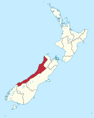
The West Coast is a region of New Zealand on the west coast of the South Island. It is administered by the West Coast Regional Council, and is known co-officially as Te Tai Poutini. It comprises the territorial authorities of Buller District, Grey District and Westland District. The principal towns are Westport, Greymouth and Hokitika. The region, one of the more remote areas of the country, is also the most sparsely populated. With a population of just 32,900 people, the West Coast is the least populous region in New Zealand. The population in the region grew by 0.4% over the year to July 2023.

Aoraki / Mount Cook National Park is a national park located in the central-west of the South Island of New Zealand. It was established in October 1953 and takes its name from the highest mountain in New Zealand, Aoraki / Mount Cook. The area of the park is 707 km2 (273 sq mi), and it shares a border with Westland Tai Poutini National Park along the Main Divide of the Southern Alps. The national park consists of reserves that were established as early as 1885 to protect the area's significant landscape and vegetation. Glaciers cover 40% of the park, including the county's largest glacier, Haupapa / Tasman Glacier. In 1990, the park was included in the area designated as the Te Wāhipounamu World Heritage Site. The park is managed by the Department of Conservation (DOC) alongside Ngāi Tahu, the iwi who are mana whenua in the region.

The Cook River / Weheka is in the South Island of New Zealand. The headwaters are from the La Perouse Glacier on the western flanks of the Southern Alps / Kā Tiritiri o te Moana, and it flows west, then northeast, then northwest and into the Tasman Sea. Its tributaries include the Balfour River, fed by Balfour Glacier, and the Fox River, fed by Fox Glacier / Te Moeka o Tuawe. Much of the river lies within the Westland Tai Poutini National Park. The river was renamed from Cook River to Cook River / Weheka as a result of the Ngāi Tahu Claims Settlement Act 1998.

Te Wāhipounamu is a World Heritage Site in the south west corner of the South Island of New Zealand.

The Copland River is a river on the West Coast of the South Island of New Zealand. It flows for 20 kilometres (12 mi) from its headwaters in the Southern Alps / Kā Tiritiri o te Moana to its confluence with the Karangarua River.
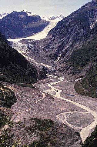
Fox Glacier is a 13-kilometre-long (8.1 mi) temperate maritime glacier located in Westland Tai Poutini National Park on the West Coast of New Zealand's South Island. Like nearby Franz Josef Glacier, Fox Glacier is one of the most accessible glaciers in the world, with a terminal face as low as 300 m above sea level, close to the village of Fox Glacier. It is a major tourist attraction and about 1000 people daily visit it during high tourist season.

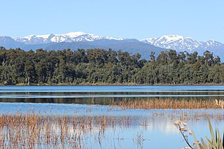
Ōkārito Lagoon is a coastal lagoon on the West Coast of New Zealand's South Island. It is located 130 kilometres (81 mi) south of Hokitika, and covers an area of about 3,240 hectares (12.5 sq mi), making it the largest unmodified coastal wetland in New Zealand. It preserves a sequence of vegetation types from mature rimu forest through mānuka scrub to brackish water that has been lost in much of the rest of the West Coast. The settlement of Ōkārito is at the southern end of the lagoon.

Ngāi Tai ki Tāmaki is a Māori tribe that is based in the area around Clevedon, part of the Auckland region. It is one of the twelve members of the Hauraki Collective of tribes.
Lake Mahinapua is a shallow lake on the West Coast of New Zealand's South Island. Once a lagoon at the mouth of the Hokitika River, it became a lake when the river shifted its course. Lake Māhinapua was the site of a significant battle between Ngāi Tahu and Ngāti Wairangi Māori, and is regarded by them as a sacred site where swimming and fishing are prohibited. In European times it was part of an inland waterway that carried timber and settlers between Hokitika and Ross until the building of the railway. Today it is protected as a scenic reserve for boating, camping, and hiking.

The Westland temperate forests, also known as the Westland temperate rainforests, is a temperate broadleaf and mixed forests ecoregion located along the central west coast of New Zealand’s South Island, also known as Te Waipounamu. These forests are found in the region of the Westland District, which spans approximately 11,880 square kilometers. It is bounded on the west by the Tasman Sea, and on the east by the Southern Alps. Much of this area is protected by the Westland Tai Poutini National Park.

The Copland Pass is an alpine pass in the Southern Alps of New Zealand. Known as Noti Hinetamatea by the indigenous Ngāi Tahu, the pass follows the route of the Makaawhio ancestor Hinetamatea and her sons Tātāwhākā and Marupeka.

Lake Gault is a small glacial lake in South Westland, New Zealand, near the township of Fox Glacier. A walking track from Lake Matheson leads to the lake, which is surrounded by mature native forest. A small hydro-electric power plant was constructed piping water from the lake to power a gold mining dredge at Gillespies Beach. Endangered Ōkārito kiwi (rowi) have been released into the wild around Lake Gault.
Gillespies Beach is a black sand beach and settlement on the West Coast of New Zealand's South Island, 20 kilometres (12 mi) west of Fox Glacier township by road. It is bounded by Westland Tai Poutini National Park to the east, and the Tasman Sea to the west. The beach itself stretches about five kilometres (3.1 mi) from Gillespies Point / Kōhaihai in the north to Otorokua Point in the south.

Waiau Glacier Coast Marine Reserve is a marine reserve of the West Coast Region of New Zealand's South Island. It covers an area of 4,641 hectares or 46 km2, from 11 km south from Kohuamarua Bluff near Ōkārito, to Omoeroa Bluff, and about 4 km out to sea.

Lake Wahapo is a small glacial lake in South Westland, New Zealand, within the Westland Tai Poutini National Park and near the township of Whataroa. It was a traditional mahinga kai for local Māori. State Highway 6 skirts the lake's southern shore. The lake discharges to the Ōkārito River via a small hydroelectric power station commissioned in 1960. The ecology of the lake has altered considerably since 1967, when the Waitangitāhuna River changed course to flow into the lake.

The Copland Track is a tramping track in the south Westland area of New Zealand's South Island, well known for the naturally-occurring hot springs at Welcome Flat along its route. The main track is approximately 25 kilometres (16 mi) long one-way from the trailhead at State Highway 6 to the track's inland end at the Douglas Rock Hut, and is usually completed in 2 to 4 days depending on whether the full distance is walked, with many opting to walk only as far as Welcome Flat. The track is the western portion of a longer path which historically connected the West Coast to Mount Cook Village via Copland Pass, however erosion and the retreat of the Hooker Glacier has led to the eastern side of this route becoming increasingly dangerous to traverse.

Gillespies Point is a small headland on the west coast of New Zealand's South Island. The point marks the north-eastern end of Gillespies Beach and the western end of Waikowhai Bluff, as well as the mouth of Waikowhai Stream. The point is deemed to have high conservation value despite not being covered by Westland Tai Poutini National Park or Waiau Glacier Coast Marine Reserve, and is a relatively untouched haul-out site of New Zealand fur seals.


