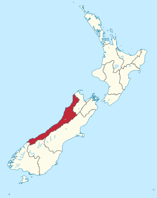
The West Coast is a region of New Zealand on the west coast of the South Island. It is administered by the West Coast Regional Council, and is known co-officially as Te Tai Poutini. It comprises the territorial authorities of Buller District, Grey District and Westland District. The principal towns are Westport, Greymouth and Hokitika. The region, one of the more remote areas of the country, is also the most sparsely populated. With a population of just 32,900 people, the West Coast is the least populous region in New Zealand. The population in the region grew by 0.4% over the year to July 2023.

Hokitika is a town in the West Coast region of New Zealand's South Island, 40 kilometres (25 mi) south of Greymouth, and close to the mouth of the Hokitika River. It is the seat and largest town in the Westland District. The town's estimated population is 3,120 as of June 2023.

Ross is a small town located in the Westland District on the West Coast of New Zealand's South Island, 27 kilometres (17 mi) south-west of Hokitika and 46 kilometres (29 mi) north-east of Hari Hari by road.

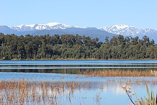
Lake Kaniere is a glacial lake located on the West Coast of New Zealand's South Island, nearly 200 m deep and surrounded on three sides by mountains and mature rimu forest. It is regarded by many as the most beautiful of the West Coast lakes, and is a popular tourist and leisure destination.

Westland District is a territorial authority district on the West Coast of New Zealand's South Island. It is administered by the Westland District Council. The district's population is 8,940.

The Westland Province was a province of New Zealand from 1873 until the abolition of provincial government in 1876. The capital was Hokitika.
Lake Mahinapua is a shallow lake on the West Coast of New Zealand's South Island. Once a lagoon at the mouth of the Hokitika River, it became a lake when the river shifted its course. Lake Māhinapua was the site of a significant battle between Ngāi Tahu and Ngāti Wairangi Māori, and is regarded by them as a sacred site where swimming and fishing are prohibited. In European times it was part of an inland waterway that carried timber and settlers between Hokitika and Ross until the building of the railway. Today it is protected as a scenic reserve for boating, camping, and hiking.

Whataroa is a small township in southern Westland on the West Coast of New Zealand's South Island. It is located on alluvial flats to the west of the Whataroa River. State Highway 6 passes through Whataroa on its route from Ross to Franz Josef / Waiau. Hari Hari is 31 kilometres (19 mi) to the north-east, and Franz Josef is 32 km to the south-west.

Bruce Bay is a bay and settlement in South Westland, New Zealand on the Tasman Sea. It is located on State Highway 6, 74 kilometres (46 mi) northeast of Haast and 45 kilometres (28 mi) southwest of Fox Glacier. The small settlement of Bruce Bay is located just south of the mouth of Mahitahi River. The bay is a nesting ground for the Fiordland crested penguin, and endemic Hector's dolphins and southern right whales can be observed from the shore on occasion. Some of the bush around the bay has been cleared for farming, and quartz stones can be found on the beach.
Agnes Addison was a New Zealand draper.
Westland District Council is the territorial authority for the Westland District of New Zealand.

James Holmes was a member of the New Zealand Legislative Council from Hokitika on the West Coast.
Westland County, also known as County of Westland, was a local government area on the West Coast of New Zealand's South Island. It existed from 1868 to 1873, and then from 1876 until 1989. In its first incarnation, it constituted the government for the area that was split from the Canterbury Province, with the West Coast Gold Rush having given the impetus for that split. It had the same administrative powers as a provincial council, but the legislative power rested with Parliament in Wellington. The first Westland County was the predecessor to Westland Province.

The Hokitika Borough was the borough council covering the urban part of the town of Hokitika, New Zealand between 1867 and 1989, when Hokitika Borough and Westland County merged to form Westland District.

Stuart and Chapman's bush tramway, Rimu was a 20 kilometres (12 mi) long bush tramway with a gauge of probably 2-foot 6-inch (762 mm) at Seddon's Terrace Sawmill in Rimu, New Zealand. It ran south of Ross to the Lake Ianthe area. It was used from at least 1899 to 1962.

Wallsend is a locality in the West Coast region of New Zealand, located on the south side of the Grey River. It is located opposite Taylorville. The two settlements were connected via a suspension bridge for pedestrians that was known as the Taylorville bridge.

Hokitika Museum is a museum in Hokitika on the West Coast of the South Island in New Zealand, and is the West Coast's largest museum and archive. It is housed in the historic Hokitika Carnegie Library building. Exhibitions include information about the gold rush and the unique West Coast stone pounamu (greenstone) and its value to Māori. The museum also holds a significant photographic collection. Seismic strengthening requirements closed the museum in September 2019. According to the Westland District Council Web site as of December 2021 the museum had not yet reopened.
Elizabeth Mary Hudson was an early nurse in Hokitika on the West Coast of the South Island of New Zealand.
The Ross Borough was the borough council covering the town of Ross, New Zealand and the nearby locality Donoghues, between 1878 and 1972, when Ross Borough was merged back into Westland County.
Westland Hospital was one of two hospitals in Hokitika, on the West Coast of New Zealand. It was founded in 1865 and closed in 1989.
