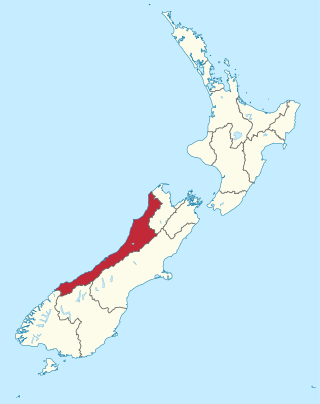
The West Coast is a region of New Zealand on the west coast of the South Island. It is administered by the West Coast Regional Council, and is known co-officially as Te Tai Poutini. It comprises the territorial authorities of Buller District, Grey District and Westland District. The principal towns are Westport, Greymouth and Hokitika. The region, one of the more remote areas of the country, is also the most sparsely populated. With a population of just 32,900 people, the West Coast is the least populous region in New Zealand. The population in the region grew by 0.4% over the year to July 2023.

Riverton, officially Riverton / Aparima, is a small New Zealand town 30 kilometres (19 mi) west of Invercargill, on the south-eastern shorelines of the Jacobs River Estuary. The estuary is formed by the Aparima and Pourakino rivers, leading through a narrow outflow channel into Foveaux Strait. Accessible via State Highway 99 on the Southern Scenic Route, the main part of the town is on flat land and the northern end of Oreti Beach. South Riverton is built on the hills between the eastern shore of the estuary and Taramea Bay.
Ngāi Tahu, or Kāi Tahu, is the principal Māori iwi (tribe) of the South Island. Its takiwā is the largest in New Zealand, and extends from the White Bluffs / Te Parinui o Whiti, Mount Mahanga and Kahurangi Point in the north to Stewart Island / Rakiura in the south. The takiwā comprises 18 rūnanga corresponding to traditional settlements. According to the 2018 census an estimated 74,082 people affiliated with the Kāi Tahu iwi.

Hokitika is a town in the West Coast region of New Zealand's South Island, 40 kilometres (25 mi) south of Greymouth, and close to the mouth of the Hokitika River. It is the seat and largest town in the Westland District. The town's estimated population is 3,120 as of June 2023.

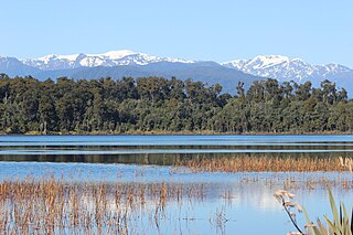
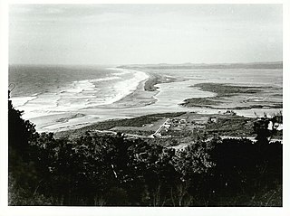
Ōkārito Lagoon is a coastal lagoon on the West Coast of New Zealand's South Island. It is located 130 kilometres (81 mi) south of Hokitika, and covers an area of about 3,240 hectares (12.5 sq mi), making it the largest unmodified coastal wetland in New Zealand. It preserves a sequence of vegetation types from mature rimu forest through mānuka scrub to brackish water that has been lost in much of the rest of the West Coast. The settlement of Ōkārito is at the southern end of the lagoon.

Westland Tai Poutini National Park is a national park located on the western coast of New Zealand's South Island. Established in 1960 as Westland National Park to commemorate the centenary of the European settlement of Westland District, it covers 1,320 square kilometres of largely mountainous terrain and forest. The park borders the Aoraki / Mount Cook National Park along the Main Divide of the Southern Alps, and includes many of the West Coast's glaciers, most notably including the Fox / Te Moeka o Tuawe and Franz Josef / Kā Roimata o Hine Hukatere glaciers.

Westland District is a territorial authority district on the West Coast of New Zealand's South Island. It is administered by the Westland District Council. The district's population is 8,940.
Lake Mahinapua is a shallow lake on the West Coast of New Zealand's South Island. Once a lagoon at the mouth of the Hokitika River, it became a lake when the river shifted its course. Lake Māhinapua was the site of a significant battle between Ngāi Tahu and Ngāti Wairangi Māori, and is regarded by them as a sacred site where swimming and fishing are prohibited. In European times it was part of an inland waterway that carried timber and settlers between Hokitika and Ross until the building of the railway. Today it is protected as a scenic reserve for boating, camping, and hiking.

Whataroa is a small township in southern Westland on the West Coast of New Zealand's South Island. It is located on alluvial flats to the west of the Whataroa River. State Highway 6 passes through Whataroa on its route from Ross to Franz Josef / Waiau. Hari Hari is 31 kilometres (19 mi) to the north-east, and Franz Josef is 32 km to the south-west.

Whangape Harbour is a harbour on the west coast of Northland, New Zealand. There is a settlement called Whangape on the northern side of the harbour. Another, called Pawarenga, is located on the southern side. Kaitaia is 42 km north east.
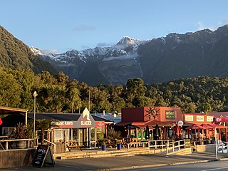
Fox Glacier, called Weheka until the 1940s, is a village on the West Coast of the South Island of New Zealand. The village is close to the eponymous Fox Glacier / Te Moeka o Tuawe.

Jacobs River is a locality in the West Coast region of the South Island of New Zealand, situated just to the north of where State Highway 6 crosses the Jacobs River. Bruce Bay is about 7 kilometres (4 mi) to the south-west, and Fox Glacier is almost 40 kilometres (25 mi) to the north-east, by road.

The West Coast Gold Rush, on the West Coast of New Zealand's South Island, lasted from 1864 to 1867.

Charles Edward Douglas was a New Zealand surveyor and explorer, who came to be known as Mr. Explorer Douglas, owing to his extensive explorations of the West Coast of New Zealand and his work for the New Zealand Survey Department. He was awarded the Royal Geographical Society Gill Memorial Prize in 1897.
Ōkārito is a small coastal settlement on the West Coast of New Zealand's South Island, 127 kilometres (79 mi) southwest of Hokitika, and 10 kilometres (6.2 mi) from State Highway 6. It is built at the southern end of the Ōkārito Lagoon at the mouth of the Ōkārito River. The settlement of The Forks is located just inland, on the banks of the river.
Te Atiawa o Te Waka-a-Māui is a Māori iwi (tribe) in the upper South Island of New Zealand. Its rohe extends from Golden Bay and Marlborough Sounds at the top of the South Island to Cape Campbell, St Arnaud and Westport.
Charles Eldon Fayne Robinson is a New Zealand Māori artist specialising in carving. Robinson has contributed to the carving of buildings on many marae in New Zealand as well as exhibiting his art in galleries and museums.
The Pounamu Pathway is a $34.5 million New Zealand tourism venture, launched in 2020 by the Māori hapū or subtribe Te Rūnanga o Ngāti Waewae, intended to create four linked visitor experience centres on the West Coast of the South Island. The visitor centres will tell stories of the West Coast's early Māori history and the importance of pounamu or greenstone.

Lake Wahapo is a small glacial lake in South Westland, New Zealand, within the Westland Tai Poutini National Park and near the township of Whataroa. It was a traditional mahinga kai for local Māori. State Highway 6 skirts the lake's southern shore. The lake discharges to the Ōkārito River via a small hydroelectric power station commissioned in 1960. The ecology of the lake has altered considerably since 1967, when the Waitangitāhuna River changed course to flow into the lake.

The historic Haast to Paringa Cattle Track is a trail through South Westland, New Zealand, constructed in 1875 to allow farmers in the Landsborough and Cascade Valley area to drive their cattle on an annual two-week journey to the sale yards in Whataroa. It was constructed as an inland loop to bypass the precipitous cliffs at Knights Point. For 90 years it was the only land access to the settlements of Haast and Jackson Bay, but the last mob of cattle was driven in 1961, and the construction of a highway connecting Paringa to Haast Pass in 1965 made it redundant. After falling into disuse, the cattle track was converted into a 33-kilometre (21 mi), three-day tramping track, opening in 1981. The track and its three huts are maintained by the New Zealand Department of Conservation.


