
The Remarkables are a mountain range and skifield in Otago in the South Island of New Zealand. Located on the southeastern shore of Lake Wakatipu, the range lives up to its name by rising sharply to create a remarkable backdrop for the waters. The range is clearly visible from the nearby town of Queenstown.

Mount Taranaki is a dormant stratovolcano in the Taranaki region on the west coast of New Zealand's North Island. At 2,518 metres (8,261 ft), it is the second highest mountain in the North Island, after Mount Ruapehu. It has a secondary cone, Fanthams Peak, 1,966 metres (6,450 ft), on its south side.

Orewa is a settlement in the northern Auckland Region of New Zealand. It is a suburb of the Hibiscus Coast, just north of the base of the Whangaparāoa Peninsula and 40 kilometres (25 mi) north of central Auckland. The Northern Motorway, part of State Highway 1, passes just inland of Orewa and extends through the twin Johnston Hill tunnels to near Puhoi.

Mount Burnett is a hill in Kahurangi National Park, in Golden Bay / Mohua, New Zealand.

The Paparoa Range is a mountain range in the West Coast region of New Zealand's South Island. It was the first New Zealand land seen by a European – Abel Tasman in 1642. Part of the range has the country's highest protection as a national park; the Paparoa National Park was established in 1987. Within that park, the Cave Creek disaster occurred in 1995.
Mount Adams is a mountain in the West Coast region of New Zealand's South Island. The summit is roughly 19 km south of Harihari and reaches 2,208 metres (7,244 ft) in height.
Abut Head is a forested headland on the West Coast of New Zealand's South Island. It is located north of the village of Whataroa and west of Harihari, and is southwest of the Westland District's main centre, Hokitika. On the southern side of the headland, the Whataroa River meets the Tasman Sea. To the east is the Saltwater Lagoon.
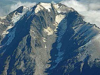
The Volta Glacier is located in Mount Aspiring National Park in the Southern Alps of the South Island of New Zealand.
The Butler River is a river of New Zealand. The source of the river is the Whataroa Glacier on the north western slopes of McKinnon Peak in the Southern Alps. From there the river flows in a west direction reaching the Whataroa River 15 kilometres (9 mi) southeast of Whataroa.

Te Awa o Mokotūāraro, formerly known as the Clive River, is a river in Hawke's Bay, New Zealand. At 33 kilometres (21 mi) long, it is the shortest of the main rivers flowing through the Heretaunga Plains.

The Ōkārito River is a river of the West Coast Region of New Zealand's South Island. It flows northwest from the northern end of Lake Mapourika, reaching the Ōkārito Lagoon 15 kilometres west of Whataroa.
The Rotokino River is a short river of the West Coast Region of New Zealand's South Island. It flows south from Lake Rotokino, draining its waters to the Whataroa River.

The Waitangitāhuna River are two rivers in the West Coast region of New Zealand's South Island. It was a single river until an avulsion in March 1967, when it became two rivers. Since then, the southern portion of the river has flowed into Lake Wahapo, while the northern section discharges into the Tasman Sea north of Ōkārito Lagoon.

The Butler Range is a range located in the Ashburton District of Canterbury on the South Island of New Zealand. To the south of the range is the Rakaia River. The area was first farmed by Samuel Butler, who called his holding Mesopotamia Station. The highest peak of Butler Range is Lauper Peak at 2,485 metres (8,153 ft), named after the Swiss-born explorer Jakob Lauper. Mount Butler is located further south in the Butler Range and is also named after Samuel Butler.

Te Toiokawharu is a hill in the Waitākere Ranges of the Auckland Region of New Zealand's North Island. At 474-metres, it is the tallest peak of the Waitākere Ranges. The peak has a low prominence due to surrounding hills of similar sizes.

Mount Haast is a mountain summit located in the Southern Alps / Kā Tiritiri o te Moana, in the Westland District of New Zealand. The mountain was named after the German-born geologist Julius von Haast by James Mackay (1831–1912).

Mount Haast is a hill located near Springs Junction, in the Buller District of New Zealand. The hill is prominent when approaching Springs Junction from the south-east on State Highway 7, where the pyramidal shape gives the (wrong) impression of a volcanic cone. The hill was named after the German-born geologist Julius von Haast by James Mackay (1831–1912).
Rakataura, also known as Hape or Rakatāura, is a legendary Polynesian navigator and a progenitor of many Māori iwi. Born in Hawaiki, Rakataura was the senior tohunga (priest/navigator) who led the Tainui migratory canoe to New Zealand. Rakataura is associated with stories involving the Manukau Harbour, the Te Tō Waka and the Waikato. Many place names in Tāmaki Makaurau and the Waikato region reference Rakataura, or are described in oral traditions as being named by Rakataura.
Ngā Oho, also known as Ngā Ohomatakamokamo-o-Ohomairangi, is the name of a historical iwi (tribe) of Māori who settled in the Auckland Region. In the 17th century, Ngā Oho and two other tribes of shared heritage, Ngā Riki and Ngā Iwi, formed the Waiohua confederation of tribes.
The Wharepapa / Arthur Range is a mountain range partially marking the boundary between the Tasman District and West Coast Region of New Zealand's South Island. The range is at the eastern extent of the Tasman Mountains which make up much of the island's northwest, making it easily visible from across the low-lying Waimea Plains further to the east. The range's location and its many uses make it a significant site for local Māori, including the iwi of Te Ātiawa and Ngāti Rārua. This includes the prominent peaks of Mount Arthur and Pukeone / Mount Campbell, which both hold mana in their own right and have become part of the identity of the aforementioned iwi.

