
The Okarito kiwi, also known as the rowi or Okarito brown kiwi, is a member of the kiwi family Apterygidae, described as new to science in 2003. The species is part of the brown kiwi complex, and is morphologically very similar to other members of that complex. It is found in a restricted area of the Ōkārito forest on the West Coast of New Zealand's South Island, and has a population of only about 600 birds.

Hari Hari is a small rural settlement in the south west of the West Coast region of New Zealand's South Island. It is slightly inland from the Tasman Sea and the Saltwater Lagoon and is situated between the Wanganui and Poerua Rivers, 45 minutes south of the tourist town of Hokitika. State Highway 6 passes through the town on its route from Ross to the Franz Josef Glacier. The Westland District's largest town, Greymouth is 110 kilometres (68 mi), and Hokitika 70 km (43 mi) to the north-east. Ross is 46 km (29 mi) to the north-east, and Franz Josef is 32 km south west.
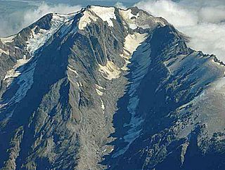
Mount Adams is a mountain in the West Coast region of New Zealand's South Island. The summit is roughly 19 km south of Harihari and reaches 2,208 metres (7,244 ft) in height.

The Perth River is a river in the Southern Alps in the West Coast region of New Zealand's South Island. Its source is in terrace icefields north of the Rangitata Divide and is joined by multiple tributaries, including a creek from Abel Lake. It features a number of rapids and passes through two gorges before meeting the Whataroa River. The river is largely inaccessible, but recently, an adventure tourism company has begun offering "heli-rafting" on the river: whitewater rafters are flown in by helicopter to raft the river.

The Whataroa River, sometimes the Wataroa River, is a river in the southern West Coast region of New Zealand's South Island. Its source is in the Southern Alps and it flows north and northwest, passing the township of Whataroa on the eastern side before reaching the Tasman Sea just south of Abut Head. The river is fed by many tributaries, such as the Perth River, and is crossed by State Highway 6 on its route between Whataroa and Te Taho.

Whataroa is a small township in southern Westland on the West Coast of New Zealand's South Island. It is located on alluvial flats to the west of the Whataroa River. State Highway 6 passes through Whataroa on its route from Ross to Franz Josef / Waiau. Hari Hari is 31 kilometres (19 mi) to the north-east, and Franz Josef is 32 km to the south-west.
Saltwater Lagoon is a lagoon on the West Coast of New Zealand's South Island.
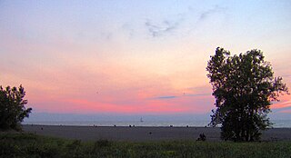
Headlands Beach State Park is a public beach in Mentor and Painesville Township, Ohio, United States. It is the longest natural beach in Ohio and attracts two million visitors annually. The breakwall at the eastern end of the park, frequented by fishermen, is surmounted by the Fairport Harbor West Breakwater Light. The park features a 35-acre beach for sunbathing, swimming, and beach glass hunting along with picnicking facilities and seasonal concessionaire.
Mendocino Headlands State Park is a California State Park in Mendocino, California. It consists of 347 acres (1.4 km2) of undeveloped seaside bluffs and islets surrounding the town of Mendocino, two beaches, and the much larger Big River Unit stretching for eight miles (13 km) along both banks of the nearby Big River.

Achilles Point is a rocky point on the headland at the eastern end of the small sandy beach named Ladies Bay, Auckland, New Zealand. The name 'Te Pane o Horoiwi' can also sometimes refer to the whole headland between St Heliers and Tamaki River estuary. Achilles Point is named after a ship called HMNZS Achilles (70) which defeated the German pocket battleship Admiral Graf Spee in 1939. The headland, from the point round to the Tamaki heads, was previously known as Te Pane o Horoiwi, named after Horoiwi who arrived in New Zealand on the Tainui canoe (waka).
West Coast is a former New Zealand Parliamentary electorate, from 1972 to 1996.
The Butler River is a river of New Zealand. The source of the river is the Whataroa Glacier on the north western slopes of McKinnon Peak in the Southern Alps. From there the river flows in a west direction reaching the Whataroa River 15 kilometres (9 mi) southeast of Whataroa.
The Gunn River is a river on the West Coast of New Zealand. It starts in the Price Range and flows east into the Whataroa River, which eventually drains into the Tasman Sea.

The Ōkārito River is a river of the West Coast Region of New Zealand's South Island. It flows northwest from the northern end of Lake Mapourika, reaching the Ōkārito Lagoon 15 kilometres west of Whataroa.
The Rotokino River is a short river of the West Coast Region of New Zealand's South Island. It flows south from Lake Rotokino, draining its waters to the Whataroa River.

The Waitangitāhuna River are two rivers in the West Coast region of New Zealand's South Island. It was a single river until an avulsion in March 1967, when it became two rivers. Since then, the southern portion of the river has flowed into Lake Wahapo, while the northern section discharges into the Tasman Sea north of Ōkārito Lagoon.
Totara was a parliamentary electorate in the West Coast of New Zealand from 1871 to 1881. It was represented by two Members of Parliament

The Butler Range, also known as North Butler Range, is a range located in the Westland District of the West Coast Region on the South Island of New Zealand. The range has also been known as Peaks of the Mist Range.

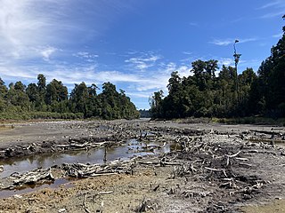
Lake Wahapo is a small glacial lake in South Westland, New Zealand, within the Westland Tai Poutini National Park and near the township of Whataroa. It was a traditional mahinga kai for local Māori. State Highway 6 skirts the lake's southern shore. The lake discharges to the Ōkārito River via a small hydroelectric power station commissioned in 1960. The ecology of the lake has altered considerably since 1967, when the Waitangitāhuna River changed course to flow into the lake.

Gillespies Point is a small headland on the west coast of New Zealand's South Island. The point marks the north-eastern end of Gillespies Beach and the western end of Waikowhai Bluff, as well as the mouth of Waikowhai Stream. The point is deemed to have high conservation value despite not being covered by Westland Tai Poutini National Park or Waiau Glacier Coast Marine Reserve, and is a relatively untouched haul-out site of New Zealand fur seals.
