
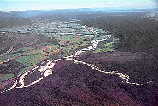
The Cook River / Weheka is in the South Island of New Zealand. The headwaters are from the La Perouse Glacier on the western flanks of the Southern Alps / Kā Tiritiri o te Moana, and it flows west, then northeast, then northwest and into the Tasman Sea. Its tributaries include the Balfour River, fed by Balfour Glacier, and the Fox River, fed by Fox Glacier / Te Moeka o Tuawe. Much of the river lies within the Westland Tai Poutini National Park. The river was renamed from Cook River to Cook River / Weheka as a result of the Ngāi Tahu Claims Settlement Act 1998.

The Copland River is a river on the West Coast of the South Island of New Zealand. It flows for 20 kilometres (12 mi) from its headwaters in the Southern Alps / Kā Tiritiri o te Moana to its confluence with the Karangarua River.

Arthur's Pass is a mountain pass in the Southern Alps of the South Island of New Zealand. The pass sits 920 metres or 3,020 feet above sea level and marks part of the boundary between the West Coast and Canterbury regions. Located 140 km from Christchurch and 95 km from Greymouth, the pass comprises part of a saddle between the valleys of the Ōtira River and of the Bealey River. Arthur's Pass lies on the border of the Selwyn and Westland districts.

Otehake River is located on the West Coast of the South Island of New Zealand. It flows northward through the Arthur's Pass National Park and into the Taramakau River.

Lake Hāwea is New Zealand's ninth largest lake.

The Manawatū River is a major river of the lower North Island of New Zealand. The river flows from the Ruahine Ranges, through both the Manawatū Gorge and the city of Palmerston North, and across the Manawatū Plains to the Tasman Sea at Foxton.
Cronadun is a small village located in the West Coast region of New Zealand's South Island. It is situated on the east bank of the Inangahua River, near its junction with Boatmans Creek. SH 69 and the Stillwater–Westport Line railway pass through the village.

Crooked River is a river that flows from headwaters in the Southern Alps to Lake Brunner in the West Coast region of New Zealand's South Island. It is named for the erratic path it takes. Near Lake Brunner, it passes through reasonably flat farmland, but closer to its source, it rushes through gorges and rapids. One tributary is the Poerua River from Lake Poerua.

The Cust River is a river in the Canterbury region of New Zealand. It flows east across the upper Canterbury Plains from its source north of the town of Oxford, New Zealand, flowing into the Cam River / Ruataniwha close to the town of Rangiora. The small town of Cust lies on the banks of the river. The lower part of the river, to the south-west of Rangiora, is diverted into a channel and called the "Main Drain". The channel was built in 1862 to drain the swampy land between Rangiora and the Waimakariri River, and when it was enlarged in 1868 it accidentally captured the Cust.
The Deception River is a river in New Zealand. It is a tributary of the West Coast's Ōtira River, flowing generally north for 17 kilometres (11 mi) from its source on the slopes of Mount Franklin. It passes close to Goat Pass, which gives access to the Mingha River. Almost the entire length of the river is within the Arthur's Pass National Park.
The Douglas River, formerly known as the Twain, is a river of the West Coast of New Zealand's South Island. Its source is high in the Southern Alps / Kā Tiritiri o te Moana, five kilometres (3.1 mi) south of Mount Sefton, and its upper reaches are fed by water from the Douglas Glacier. It flows west for 18 kilometres (11 mi), joined by runoff from the Horace Walker Glacier, before joining the waters of the Karangarua River. The Douglas River's entire course is within Westland Tai Poutini National Park. The river and glacier are named after Charles Edward Douglas, a 19th-century explorer and mountaineer.
The Drake River is a river of New Zealand. It is located in southern Westland, and flows entirely within the Mount Aspiring National Park. The river follows a southerly course for seven kilometres before turning northeast to flow another five kilometres before reaching the Waiatoto River.
The Gorge River is a river on the West Coast of New Zealand. It arises in the Hope Blue River Range and flows south-west into the Tasman Sea. Its tributaries include the Duncan River and Jerry River. It passes through Cascade Forest. Its mouth is about 15 km north-east of Awarua Point. The Gorge Islands are very small islands near the mouth. At its mouth, it is a fast tidal river.
The Gunn River is a river on the West Coast of New Zealand. It starts in the Price Range and flows east into the Whataroa River, which eventually drains into the Tasman Sea.
The Hall River is a river on the West Coast of New Zealand. It drains Lake Paringa, flowing north to the Paringa River, which drains into the Tasman Sea.
The Hapuka River is a river of Westland District, New Zealand. It flows from near The Woolsack north-west to join the Okuru and Turnbull Rivers just before they enter the Tasman Sea. The river is slow-moving and drains swampy land. There are brown trout in the lagoon area.

The Fox River is a river in the Westland District of New Zealand. It arises in two places; from a spring in the Fox Range, and from the head of the Fox Glacier. It runs west into the Cook River / Weheka, shortly before it exits into the Tasman Sea.
The Duncan River is a river in the West Coast Region of New Zealand. It arises in the Red Hills Range and flows north-east to the Gorge River, which flows west into the Tasman Sea.
The Donald River is a short tributary of the Waiatoto River within Mount Aspiring National Park. It flows west for 6 kilometres (4 mi) from the Donald Glacier on the western slopes of Mount Pollux.

The Olivine Ice Plateau is a glacier in the Olivine Wilderness Area and Aspiring National Park in New Zealand's South Island. The plateau is named after the mineral olivine, which is common within the Dun Mountain Ophiolite that underlies the area. The plateau extents to the west over the Forgotten River Col. into the Forgotten River and to the north it merges with the Andy Glacier, which feeds a tributary of the Arawhata River. The Olivine Ice Plateau is one of many glaciers in the region of the Arawhata, Dart / Te Awa Whakatipu, Hollyford / Whakatipu Kā Tuka and Matukituki rivers' headwaters.


