
Sir Johann Franz Julius von Haast was a German-born New Zealand explorer, geologist, and founder of the Canterbury Museum in Christchurch.

Haast is a small town in the Westland District on the West Coast of New Zealand's South Island. The township is beside the Haast River, 3 kilometres (2 mi) south of Haast Junction, on State Highway 6. The Haast region is in Te Wahipounamu – The South West New Zealand World Heritage, a UNESCO World Heritage Site designated in 1990.

Jackson Bay / Okahu is a gently curving 24-kilometre (15 mi) bay on the southern West Coast of the South Island of New Zealand. It faces the Tasman Sea to the north, and is backed by the Southern Alps. It contains the settlements of Hannahs Clearing, Waiatoto, Neils Beach, and the fishing village of Jackson Bay at its western end. The bay is the southernmost terminus of the West Coast's roads.

The Haast River / Awarua is a river on the West Coast of the South Island of New Zealand. The Māori name for the river is Awarua. It drains the western watershed of the Haast Pass. The Haast River is 100 kilometres (62 mi) in length, and enters the Tasman Sea near Haast township. The river's main tributary is the Landsborough River.
The Turnbull River is a short river on the West Coast of New Zealand's South Island. It flows northwest from the Southern Alps for 22 kilometres (14 mi), entering the Tasman Sea at the northern end of Jackson Bay, 10 kilometres (6.2 mi) south of Haast. The Turnbull shares its mouth with the Okuru River.

The Landsborough River is located in New Zealand's South Island. A major tributary of the Haast River, it flows southwest, parallel with the Southern Alps, for 50 kilometres from its source five kilometres north of Mount Hopkins to meet the Haast 12 kilometres below the Haast Pass.
Knights Point is on the West Coast of New Zealand's South Island.

The Nottaway River is a river in Quebec, Canada. The river drains Lake Matagami and travels 225 kilometers (140 mi) north-west before emptying into Rupert Bay at the south end of James Bay. Its drainage basin is 65,800 square kilometers (25,400 sq mi) and has a mean discharge of 1190 m3/s. Its source is the head of the Mégiscane River, which is 776 kilometers (482 mi) from the mouth.

State Highway 6 is a major New Zealand state highway. It extends from the Marlborough region in the northeastern corner of the South Island across the top of the island, then down the length of the island, initially along the West Coast and then across the Southern Alps through inland Otago and finally across the Southland Plains to the island's south coast. Distances are measured from north to south.
The Open Bay Islands are located in South Westland, off the south-west coast of the South Island of New Zealand. They consist of two main islands, Taumaki and Popotai, plus several smaller islets and rocks. They lie approximately 5 km (3.1 mi) offshore from the Okuru River mouth, near Haast, and are owned by the West Coast branch Māori iwi Ngāi Tahu known as Poutini Ngāi Tahu.
The Burke River is a river of New Zealand's South Island, located in Mount Aspiring National Park. It flows east for 19 kilometres (12 mi) from close to the Mueller Pass, reaching the Haast River 10 kilometres (6 mi) south of the Haast Pass.
The Gorge River is a river on the West Coast of New Zealand. It arises in the Hope Blue River Range and flows south-west into the Tasman Sea. Its tributaries include the Duncan River and Jerry River. It passes through Cascade Forest. Its mouth is about 15 km north-east of Awarua Point. The Gorge Islands are very small islands near the mouth. At its mouth, it is a fast tidal river.
The Ngatau River is a river of the West Coast region of New Zealand's South Island. It flows north-west from its sources in the Southern Alps to meet the Okuru River 20 kilometres (12 mi) south-east of Haast. The river's entire length is within Mount Aspiring National Park.

The Waita River is in the West Coast Region of New Zealand's South Island. It flows generally west to reach the Tasman Sea 10 kilometres northeast of the mouth of the Haast River. The river has its source on the western flanks of the Mataketake Range and passes through dense native forest which opens up into farm land before passing under the State Highway 6. The Maori River is one of the tributaries of the Waita.
The Wills River is a river of the southern West Coast region of New Zealand's South Island. It flows west to reach the Haast River 10 kilometres north of the Haast Pass.

The Clarke River in Westland District is the southernmost of three rivers thus-named in the South Island of New Zealand. It is a major tributary of the Haast River, flowing southwest from its source on the slopes of Mount Hooker before joining with the Landsborough River three kilometres before the waters of both flow into the Haast at the point where the latter river turns west towards its outflow into the Tasman Sea.

Tauparikākā Marine Reserve is a marine reserve located offshore about 20 kilometres (12 mi) north of Haast on the West Coast of New Zealand's South Island. It covers the area immediately offshore from Ship Creek, which is also known as Tauparikākā in Māori.
Pleasant Flat is an alluvial floodplain of the Haast River in the Haast Pass on New Zealand's South Island. A former stopping place for travellers crossing the pass before the building of the highway, it now has a campsite and picnic shelter. It has a notable view of Mount Hooker to the northeast.

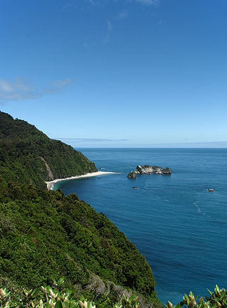
The historic Haast to Paringa Cattle Track is a trail through South Westland, New Zealand, constructed in 1875 to allow farmers in the Landsborough and Cascade Valley area to drive their cattle on an annual two-week journey to the sale yards in Whataroa. It was constructed as an inland loop to bypass the precipitous cliffs at Knights Point. For 90 years it was the only land access to the settlements of Haast and Jackson Bay, but the last mob of cattle was driven in 1961, and the construction of a highway connecting Paringa to Haast Pass in 1965 made it redundant. After falling into disuse, the cattle track was converted into a 33-kilometre (21 mi), three-day tramping track, opening in 1981. The track and its three huts are maintained by the New Zealand Department of Conservation.

Ship Creek is a small river that flows into an area of coastal swamp forest on the West Coast of New Zealand's South Island. Ship Creek is approximately 11 km (6.8 mi) long and flows northwest from catchment areas on the slopes of Bald Hill, reaching the Tasman Sea around 20 km (12 mi) north-east of Haast. Near the mouth of Ship Creek, there are short walks around dune lakes and ancient kahikatea swamp forest.


