
A distributary, or a distributary channel is a stream channel that branches off and flows away from a main stream channel. It is the opposite of a tributary, a stream that flows towards and into another stream or river. Distributaries are a result of river bifurcation and are often found where a river approaches a lake or an ocean and divides into distributary networks; as such they are a common feature of river deltas. They can also occur inland, on alluvial fans, or where a tributary stream bifurcates as it nears its confluence with a larger stream. In some cases, a minor distributary can divert so much water from the main channel that it can later become the main route.
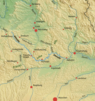
The Altmühl is a river in Bavaria, Germany. It is a left tributary of the river Danube and is approximately 230 kilometres (140 mi) long.

The River Dart is a river in Devon, England, that rises high on Dartmoor and flows for 75 kilometres (47 mi) to the sea at Dartmouth.

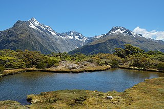
Mount Aspiring National Park is in the Southern Alps of the South Island of New Zealand, north of Fiordland National Park, situated in Otago and Westland regions. The park forms part of the Te Wahipounamu World Heritage Site.

The Buffalo River is the longest unimpounded river in Middle Tennessee in the United States. It flows 125 miles (201 km) through the southern and western portions of that region. The Buffalo is the largest tributary of the Duck River. Canoeing is popular, especially in its middle section. The river is named for the Buffalo fish which was abundant when the first European settlers arrived.

Lake Wakatipu is an inland lake in the South Island of New Zealand. It is in the southwest corner of the Otago region, near its boundary with Southland. Lake Wakatipu comes from the original Māori name Whakatipu wai-māori.

The Taieri River is the fourth-longest river in New Zealand and is in Otago in the South Island. Rising in the Lammerlaw Range, it initially flows north, then east around the Rock and Pillar range before turning southeast, reaching the sea 30 kilometres (19 mi) south of Dunedin.
The Routeburn Track is a 32 km tramping (hiking) track found in the South Island of New Zealand. The track can be done in either direction, starting on the Queenstown side of the Southern Alps, at the northern end of Lake Wakatipu or on the Te Anau side, at the Divide, several kilometres from the Homer Tunnel to Milford Sound.

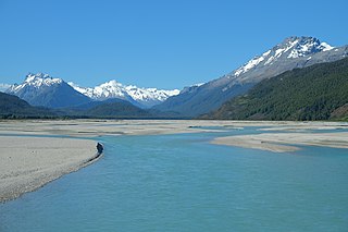
The Matukituki River is a short braided river in the Southern Alps of New Zealand's South Island. Both its West Branch and East Branch originate from the Main Divide mountain ranges near Mount Aspiring / Tititea. Their largely glacier-fed waters each flow for approximately 20 kilometres (12 mi) before joining near Camerons Flat. After this confluence, the Matukituki River leaves the boundaries of Mount Aspiring National Park and continues for another 30 kilometres (19 mi) to exit into Lake Wānaka at the lake's southwestern edge.
The Dart River flows through rugged forested country in the southwestern South Island of New Zealand. Partly in Mount Aspiring National Park, it flows south-west and then south for 60 kilometres (37 mi) from its headwaters in the Southern Alps and the Dart Glacier, eventually flowing into the northern end of Lake Wakatipu near Glenorchy.

The Missisquoi River is a transboundary river of the east shore of Lake Champlain, approximately 80 miles (130 km) long, in northern Vermont in the United States and southern Quebec in Canada.

The Waiau River is the largest river in the Southland region of New Zealand. 'Waiau' translates to 'River of Swirling Currents'. It is the outflow of Lake Te Anau, flowing from it into Lake Manapouri 10 kilometres (6 mi) to the south, and from there flows south for 70 kilometres (43 mi) before reaching the Foveaux Strait 8 kilometres (5 mi) south of Tuatapere. It also takes water from Lake Monowai.

The Kepler Track is a 60 km (37 mi) circular hiking track which travels through the landscape of the South Island of New Zealand and is situated near the town of Te Anau. The track passes through many landscapes of the Fiordland National Park such as rocky mountain ridges, tall mossy forests, lake shores, deep gorges, rare wetlands and rivers. Like the mountains it traverses, the track is named after Johannes Kepler. The track is one of the New Zealand Great Walks and is administered by the Department of Conservation (DOC).

The Châteauguay River is a tributary of the South Shore of the St. Lawrence River, flowing in:

Lake Marian is an alpine lake at the southern end of the Darran Mountains in the Fiordland National Park in the South Island of New Zealand. The lake is located just above the treeline in a hanging valley leading northwest from the Hollyford Valley near The Divide pass. The valley is sheltered by steep snow-covered peaks of over 2,000 metres (6,600 ft) on all sides apart from the entrance.

State Highway 94 is a New Zealand state highway connecting the large Southland town of Gore with one of New Zealand's most popular destinations, Milford Sound. It also passes the significant townships of Lumsden and Te Anau as well going through the Homer Tunnel. The road also goes through Fiordland and crosses the Main Divide of the Southern Alps.

The Ashburton River / Hakatere is a river in the Canterbury region of New Zealand, flowing across Mid Canterbury from the Southern Alps to the Pacific Ocean. The official name of the river was amended to become a dual name by the Ngāi Tahu Claims Settlement Act 1998. It has been identified as an Important Bird Area by BirdLife International because it supports breeding colonies of the endangered black-billed gull.

The Routeburn Classic mountain run is a mountain running event in New Zealand and is 32 km (20 mi) in distance, following the entire Routeburn Track. It is an annual event which was first held in 2001, and draws many local competitors as well as many international runners. Numbers are limited to about 350 for each event to reduce impact on the area, which is one of the great walks in New Zealand and is looked after by the Department of Conservation.

The Humboldt Mountains or Humboldt Range are one of the many ranges which make up the Southern Alps / Kā Tiritiri o te Moana in the South Island of New Zealand. They lie to the northwest of Lake Wakatipu in the Otago Region. Parts of the range lie within Fiordland National Park, and they form the southern extremity of Mount Aspiring National Park. The range was named by early explorer James McKerrow, and like many geographic features worldwide, it was named in honour of notable scientist Alexander von Humboldt.

Lake Sylvan is a small lake north of Lake Wakatipu in the South Island of New Zealand. It lies within the boundaries of the Mount Aspiring National Park near the Queenstown start of the Routeburn Track.


