
The Clutha River is the second longest river in New Zealand and the longest in the South Island. It flows south-southeast 338 kilometres (210 mi) through Central and South Otago from Lake Wānaka in the Southern Alps to the Pacific Ocean, 75 kilometres (47 mi) south west of Dunedin. It is the highest volume river in New Zealand, and the swiftest, with a catchment of 21,000 square kilometres (8,100 sq mi), discharging a mean flow of 614 cubic metres per second (21,700 cu ft/s). The river is known for its scenery, gold-rush history, and swift turquoise waters. A river conservation group, the Clutha Mata-Au River Parkway Group, is working to establish a regional river parkway, with a trail, along the entire river corridor.

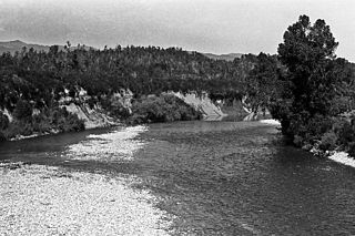
The Makarora River is in the Otago region of the South Island of New Zealand.

Arthur's Pass is a mountain pass in the Southern Alps of the South Island of New Zealand. The pass sits 920 metres or 3,020 feet above sea level and marks part of the boundary between the West Coast and Canterbury regions. Located 140 km from Christchurch and 95 km from Greymouth, the pass comprises part of a saddle between the valleys of the Ōtira River and of the Bealey River. Arthur's Pass lies on the border of the Selwyn and Westland districts.

Lewis Pass is the northernmost of the three main mountain passes through the Southern Alps in the South Island of New Zealand. With an elevation of 907 metres, it is slightly lower than Arthur's Pass and higher than Haast Pass.
The Inangahua River is located in the north-west of New Zealand’s South Island. It is a major tributary of the Buller River, where it joins at the town of Inangahua Junction.

The Conway River is part of the traditional boundary between the Canterbury and Marlborough regions in the South Island of New Zealand.

The Harper River is a tributary of the Wilberforce River which itself flows into the Rakaia River in New Zealand's Canterbury region. It is located in the Southern Alps and a pass in the Harper River headwaters leads into the Waimakariri River catchment. One of the most popular tramping routes in Canterbury enters the East Harper via Cass Saddle and exits via Lagoon Saddle at the head of the West Harper.

State Highway 7 is a major New Zealand state highway. One of the eight national highways, it crosses the Southern Alps to link the West Coast Region with Canterbury and to form a link between the South Island's two longest highways, State Highway 1 and State Highway 6. Distances are measured from east to west with the major junction list going from east to west.

State Highway 6 is a major New Zealand state highway. It extends from the Marlborough region in the northeastern corner of the South Island across the top of the island, then down the length of the island, initially along the West Coast and then across the Southern Alps through inland Otago and finally across the Southland Plains to the island's south coast. Distances are measured from north to south.

Craigieburn Forest Park is a protected area in the South Island of New Zealand, adjacent to Arthur's Pass National Park to the north.
Maungahaumi is a mountain in the Raukumara Range in the northeast of New Zealand's North Island.
The Callery River is a river of New Zealand. It lies mostly within Westland Tai Poutini National Park, and is a tributary of the Waiho River. The Callery flows west from the Callery Saddle for 16 kilometres (10 mi) before turning north to reach the Waiho close to Franz Josef township.

The Doubtful River is a river in the Canterbury region of New Zealand. It rises near Mount Barron and flows south then south-east through Lake Sumner Forest Park, reaching the Boyle River 40 kilometres (25 mi) west of Hanmer Springs. The Doubtful Range lies to the south. The Doubtless River and Devilskin Stream are tributaries entering from the north.

The Forgotten River is located in northern Fiordland, New Zealand and is a tributary of the Olivine River. The Forgotten River starts at the Forgotten River Col at the western edge of the Olivine Ice Plateau in the Five Finger Range. It flows south-westward to join the Olivine River as a hanging valley south of Four Brothers Pass.
State Highway 40 was part of the New Zealand state highway network before it was revoked in 1991–92.
The Seefeld Saddle is a saddle and mountain pass, 1,185 m (AA), in the Northern Limestone Alps in the Austrian federal state of Tyrol. Two major transport routes run over it: the Seefelder Straße (B 177) and the Mittenwald Railway. On the Seefeld Plateau north of the saddle lies the village and ski resort of Seefeld in Tirol.
The Olivine Ice Plateau is a glacier in the Olivine Wilderness Area and Aspiring National Park in New Zealand's South Island. The plateau is named after the mineral olivine, which is common within the Dun Mountain Ophiolite that underlies the area. The plateau extents to the west over the Forgotten River Col. into the Forgotten River and to the north it merges with the Andy Glacier, which feeds a tributary of the Arawhata River. The Olivine Ice Plateau is one of many glaciers in the region of the Arawhata, Dart / Te Awa Whakatipu, Hollyford / Whakatipu Kā Tuka and Matukituki rivers' headwaters.

Manuka Creek is a locality in Otago, New Zealand, on the banks of the Manuka Stream, a tributary of the Tokomairiro River. It is located a short distance to the east of State Highway 8. The Manuka Railway Station on the Roxburgh Branch line was located by it. Herbert Deveril and Albert Percy Godber photographed the railway station. The creek was once a busy site for gold mining.

The Two Thumb Range is a range of mountains in the Canterbury Region of New Zealand's South Island. It is located to the east of Lake Tekapo and has several peaks which rise to around 2,500 metres (8,200 ft). The southern end of the range contains one of Canterbury's main skifields, Mount Dobson.

The Wangapeka Track is a tramping track in the north-west of the South Island of New Zealand. It is one of the main tramping tracks in the Kahurangi National Park, a protected area managed by the Department of Conservation. The route traverses the southern end of the park, from the historic Wangapeka goldfields area west of Tapawera, to the coastal plains of the West Coast at Little Wanganui. The route is 59 km (37 mi) long, and crosses the Wangapeka and Little Wanganui saddles, each over 1,000 m (3,300 ft) in elevation. The track passes through the valleys of the Wangapeka River, Karamea River, Taipō River and Little Wanganui River. The majority of the track is in river valleys and under forest cover, with small sections in tussock land at Stag Flat and the Little Wanganui Saddle. It typically takes walkers 4–6 days to complete the route.
