| Rob Roy Peak | |
|---|---|
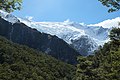
 South aspect | |
| Highest point | |
| Elevation | 2,644 m (8,675 ft) [1] [2] |
| Prominence | 458 m (1,503 ft) [2] |
| Isolation | 7.51 km (4.67 mi) [2] |
| Listing | Highest mountains of New Zealand |
| Coordinates | 44°27′06″S168°43′21″E / 44.451684°S 168.722569°E [2] |
| Naming | |
| Etymology | Rob Roy MacGregor |
| Geography | |
 Rob Roy Peak Location in New Zealand | |
 | |
| Interactive map of Rob Roy Peak | |
| Location | South Island |
| Country | New Zealand |
| Region | Otago |
| Protected area | Mount Aspiring National Park |
| Parent range | Southern Alps |
| Topo map | Topo50 CA11 [3] |
| Climbing | |
| First ascent | 2 March 1935 |
Rob Roy Peak is a 2,644-metre-elevation (8,675-foot) mountain in Otago, New Zealand.