| Mount Maori | |
|---|---|
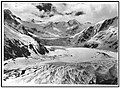
 South aspect | |
| Highest point | |
| Elevation | 2,535 m (8,317 ft) [1] [2] |
| Prominence | 309 m (1,014 ft) [2] |
| Isolation | 2.96 km (1.84 mi) [2] |
| Listing | New Zealand #63 |
| Coordinates | 44°26′09″S168°36′38″E / 44.435971°S 168.610547°E [2] |
| Naming | |
| Etymology | Māori |
| Geography | |
 Mount Maori Location in New Zealand | |
 | |
| Interactive map of Mount Maori | |
| Location | South Island |
| Country | New Zealand |
| Region | West Coast / Otago |
| Protected area | Mount Aspiring National Park |
| Parent range | Southern Alps Snowdrift Range [3] |
| Topo map(s) | NZMS260 E39 [4] Topo50 CA10 [3] |
| Climbing | |
| First ascent | March 1935 |
Mount Maori is a 2,535-metre-elevation (8,317-foot) mountain in the South Island of New Zealand.