
Haast is a small town in the Westland District on the West Coast of New Zealand's South Island. The township is beside the Haast River, 3 kilometres (2 mi) south of Haast Junction, on State Highway 6. The Haast region is in Te Wahipounamu – The South West New Zealand World Heritage, a UNESCO World Heritage Site designated in 1990.

Jackson Bay / Okahu is a gently curving 24-kilometre (15 mi) bay on the southern West Coast of the South Island of New Zealand. It faces the Tasman Sea to the north, and is backed by the Southern Alps. It contains the settlements of Hannahs Clearing, Waiatoto, Neils Beach, and the fishing village of Jackson Bay at its western end. The bay is the southernmost terminus of the West Coast's roads.
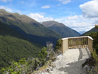
Haast Pass / Tioripatea is a mountain pass in the Southern Alps of the South Island of New Zealand. Māori used the pass in pre-European times.

Mount Aspiring National Park is in the Southern Alps of the South Island of New Zealand, north of Fiordland National Park, situated in Otago and Westland regions. The park forms part of the Te Wahipounamu World Heritage Site.

Mount Aspiring / Tititea is New Zealand's 23rd-highest mountain. The peak's altitude of 3,033 metres (9,951 ft) makes it the country's highest outside the Aoraki / Mount Cook region.

The Landsborough River is located in New Zealand's South Island. A major tributary of the Haast River, it flows southwest, parallel with the Southern Alps, for 50 kilometres from its source five kilometres north of Mount Hopkins to meet the Haast 12 kilometres below the Haast Pass.

The Paparoa Range is a mountain range in the West Coast region of New Zealand's South Island. It was the first New Zealand land seen by a European – Abel Tasman in 1642. Part of the range has the country's highest protection as a national park; the Paparoa National Park was established in 1987. Within that park, the Cave Creek disaster occurred in 1995.
The Volta Glacier is located in Mount Aspiring National Park in the Southern Alps of the South Island of New Zealand.
The Bonar River is a short river of New Zealand. It is in Mount Aspiring National Park and flows west for 5 kilometres (3 mi) before joining the Waiatoto River. Its source is on the slopes of Mount Taurus, 15 kilometres (9 mi) northeast of Mount Aspiring / Tititea.
The Burke River is a river of New Zealand's South Island, located in Mount Aspiring National Park. It flows east for 19 kilometres (12 mi) from close to the Mueller Pass, reaching the Haast River 10 kilometres (6 mi) south of the Haast Pass.
The Drake River is a river of New Zealand. It is located in southern Westland, and flows entirely within the Mount Aspiring National Park. The river follows a southerly course for seven kilometres before turning northeast to flow another five kilometres before reaching the Waiatoto River.
The Fish River, is a river in the Otago Region of New Zealand. A tributary of the Makarora River, it rises east of Mount Burke and flows south-eastward through Mount Aspiring National Park, crossing State Highway 6 at 44° 6.97'S 169° 20.66'E, to join that river south of Haast Pass.
The Ngatau River is a river of the West Coast region of New Zealand's South Island. It flows north-west from its sources in the Southern Alps to meet the Okuru River 20 kilometres (12 mi) south-east of Haast. The river's entire length is within Mount Aspiring National Park.
The Ōmoeroa River is a river of the West Coast region of New Zealand's South Island. It flows northwest from its source high in the Southern Alps, 14 kilometres north of Aoraki / Mount Cook, reaching the Tasman Sea 12 kilometres west of Franz Josef.
The Te Naihi River is a river of the Westland District of New Zealand's South Island. It flows generally northwest to reach the Waiatoto River 35 kilometres (22 mi) southwest of Haast. Much of the river's length is within Mount Aspiring National Park.
The Donald River is a short tributary of the Waiatoto River within Mount Aspiring National Park. It flows west for 6 kilometres (4 mi) from the Donald Glacier on the western slopes of Mount Pollux.

The Haast-Hollyford road or Haast-Hollyford Highway is a long-standing proposal to link Haast via the Hollyford Valley to Milford Sound and Te Anau in the South Island of New Zealand. Proposals for this road have been mooted since the 1880s.
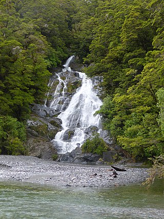
Fantail Falls is a waterfall in Mount Aspiring National Park, Westland District, New Zealand.

Roaring Billy Falls is a waterfall in Mount Aspiring National Park, Westland District, New Zealand. It is located in the Haast River valley, around 30 km (19 mi) inland from Haast, near Eighteen Mile Bluff on State Highway 6. The falls are a 30-metre-high (98 ft) cascade on The Roaring Billy stream. The bottom of the cascade is at an elevation of around 80 metres (262 ft) where it flows into the Haast River.

Thunder Creek Falls is a waterfall in Mount Aspiring National Park, Westland District, New Zealand. It is located in the Haast River valley, around 52 kilometres (32 mi) inland from Haast, near the Gates of Haast bridge on State Highway 6. The falls are about 28 metres (92 ft) high and the base is at an elevation of around 120 metres (390 ft) where it flows into the Haast River.


