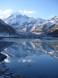
Aoraki / Mount Cook is the highest mountain in New Zealand. Its height, as of 2014, is listed as 3,724 metres. It lies in the Southern Alps / Kā Tiritiri o te Moana, the mountain range which runs the length of the South Island. A popular tourist destination, it is also a favourite challenge for mountain climbers. Aoraki / Mount Cook consists of three summits: from south to north, the Low Peak, the Middle Peak and the High Peak. The summits lie slightly south and east of the main divide of the Southern Alps / Kā Tiritiri o te Moana, with the Tasman Glacier to the east and the Hooker Glacier to the southwest.
Victoria University of Wellington is a university in Wellington, New Zealand. It was established in 1897 by Act of Parliament, and was a constituent college of the University of New Zealand.

Wellington is the capital city of New Zealand. It is located at the south-western tip of the North Island, between Cook Strait and the Remutaka Range. Wellington is the major population centre of the southern North Island, and is the administrative centre of the Wellington Region, which also includes the Kapiti Coast and the Wairarapa. It is the world's southernmost capital of a sovereign state. Wellington features a temperate maritime climate, and is the world's windiest city by average wind speed.

The North Island, also officially named Te Ika-a-Māui, is one of the two main islands of New Zealand, separated from the larger but much less populous South Island by the Cook Strait. The island's area is 113,729 square kilometres (43,911 sq mi), making it the world's 14th-largest island. It has a population of 3,896,200, accounting for approximately 77% of the total residents of New Zealand.

The South Island, also officially named Te Waipounamu, is the larger of the two major islands of New Zealand in surface area, the other being the smaller but more populous North Island. It is bordered to the north by Cook Strait, to the west by the Tasman Sea, and to the south and east by the Pacific Ocean. The South Island covers 150,437 square kilometres (58,084 sq mi), making it the world's 12th-largest island. It has a temperate climate.

The Treaty of Waitangi is a treaty first signed on 6 February 1840 by representatives of the British Crown and Māori chiefs (rangatira) from the North Island of New Zealand. It has become a document of central importance to the history, to the political constitution of the state, and to the national mythos of New Zealand, and has played a major role in framing the political relations between New Zealand's government and the Māori population, especially from the late-20th century.

The West Coast is a region of New Zealand on the west coast of the South Island that is administered by the West Coast Regional Council. It comprises the territorial authorities of Buller District, Grey District and Westland District. The principal towns are Westport, Greymouth, and Hokitika. The region is one of the more remote and most sparsely populated areas of the country.

Waitangi Day, the national day of New Zealand, marks the anniversary of the initial signing – on 6 February 1840 – of the Treaty of Waitangi, which is regarded as the founding document of the nation. The first Waitangi Day was not celebrated until 1934, and it was made a national public holiday in 1974.

The haka is a ceremonial dance or challenge in Māori culture. It is performed by a group, with vigorous movements and stamping of the feet with rhythmically shouted accompaniment. Although commonly associated with the traditional battle preparations of male warriors, haka have long been performed by both men and women, and several varieties of the haka fulfill social functions within Māori culture. Haka are performed to welcome distinguished guests, or to acknowledge great achievements, occasions or funerals.

Fox Glacier / Te Moeka o Tuawe is a 13-kilometre-long (8.1 mi) temperate maritime glacier located in Westland Tai Poutini National Park on the West Coast of New Zealand's South Island. Like nearby Franz Josef Glacier, Fox Glacier is one of the most accessible glaciers in the world, with a terminal face as low as 300 m above sea level, close to Fox Glacier village / Weheka. It is a major tourist attraction and about 1000 people daily visit it during high tourist season.

Franz Josef Glacier / Kā Roimata o Hine Hukatere is a 12 km (7.5 mi) long temperate maritime glacier in Westland Tai Poutini National Park on the West Coast of New Zealand's South Island. Together with the Fox Glacier 20 km (12 mi) to the south, and a third glacier, it descends from the Southern Alps to less than 300 metres (980 ft) above sea level.

The Museum of New Zealand Te Papa Tongarewa is New Zealand's national museum, located in Wellington. Known as Te Papa, or 'Our Place', it opened in 1998 after the merging of the National Museum and the National Art Gallery. More than 1.5 million people visit every year.

Hari Hari is a small rural settlement in the south west of the West Coast region of New Zealand's South Island. The name has a Maori meaning, from Te Aka Maori/English Dictionary, as "to take/carry joy" or, as local legend suggests, "come together in unison" from a Maori canoe paddling chant/song. In recent years, Hari Hari has been increasingly referred to as "Harihari" with Maori meaning as "ambulance". No official statutory process has taken place in order for this to happen.

Hinduism is the second largest religion in New Zealand. It is also the fastest growing religion in New Zealand. According to the 2018 census, Hindus represent 2.63% of the population of the New Zealand. There are about 123,534 Hindus in New Zealand.

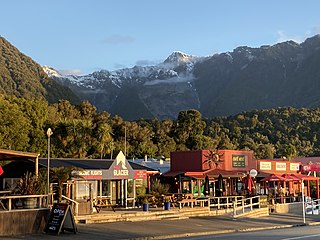
Franz Josef / Waiau is a small town in the West Coast region of the South Island of New Zealand. Whataroa is 32 kilometres (20 mi) to the north-east, and the township of Fox Glacier is 23 kilometres (14 mi) to the south-west. State Highway 6 runs through the town. The Waiho River runs from the Franz Josef Glacier to the south, through the town, and into the Tasman Sea to the north-west.
Fox Glacier is a village on the West Coast of the South Island of New Zealand. The village is close to the eponymous Fox Glacier.
Air Safaris is a New Zealand scenic flight and air charter company based at the Lake Tekapo Airport located 2.8 km west of the town of Lake Tekapo, off State Highway 8 in the Mackenzie District of New Zealand. The airline operates from 5 bases, Tekapo, Franz Josef, Glentanner, Twizel and Mt Cook airports. The company logo is a stylised chamois; these are wild goat-like antelope which inhabits the region of the South Island High Country.

The Westland temperate forests, also known as the Westland temperate rainforests, is a temperate broadleaf and mixed forests ecoregion located along the central west coast of New Zealand’s South Island, also known as Te Waipounamou. These forests are found in the region of the Westland District, which spans approximately 11,880 square kilometers. It is bounded on the west by the Tasman Sea, and on the east by the Southern Alps. Much of this area is protected by the Westland Tai Poutini National Park.

Akira Ioane is a New Zealand rugby union player. Ioane plays blindside flanker and number 8 for the Auckland rugby union team in the Mitre 10 Cup, for the Blues in the Super Rugby competition and was selected for the All Blacks in 2017, having previously represented New Zealand internationally in Sevens and the Māori All Blacks.
Isaia Walker-Leawere is a New Zealand rugby union player who plays as a lock for the Hurricanes in Super Rugby and Hawke's Bay in New Zealand's domestic Mitre 10 Cup competition.

