Franz Josef Glacier

Last updated • 9 min readFrom Wikipedia, The Free Encyclopedia

Franz Josef Glacier /
Kā Roimata o Hine Hukatere
Franz josef Glacier LC0250.jpg
Franz Josef Glacier in 2011
NZ-West Coast plain map.png
Disc Plain red.svg
Franz Josef Glacier / Kā Roimata o Hine Hukatere
LocationWestland Tai Poutini National Park
Coordinates 43°28′01″S170°11′30″E / 43.46694°S 170.19167°E / -43.46694; 170.19167
Length12 km (7.5 mi)
ThicknessUp to 300 metres (980 ft) thick
StatusRetreating

The Franz Josef Glacier (Māori : Kā Roimata o Hine Hukatere; officially Franz Josef Glacier / Kā Roimata o Hine Hukatere) is a 12-kilometre-long (7.5 mi) [1] temperate maritime glacier in Westland Tai Poutini National Park on the West Coast of New Zealand's South Island. Together with the Fox Glacier 20 kilometres (12 mi) to the south, and a third glacier, it descends from the Southern Alps to less than 300 metres (980 ft) above sea level. [2]

Contents

The area surrounding the two glaciers is part of Te Wāhipounamu, a World Heritage Site park. The Waiho River emerges from the glacier terminal of Franz Josef. [3]

Naming

The Māori name for the glacier is Kā Roimata o Hine Hukatere, literally: 'The tears of Hine Hukatere'. According to oral tradition, Hine Hukatere loved climbing in the mountains and persuaded her lover Tuawe to climb with her. Tuawe was a less experienced climber than Hine Hukatere but loved to accompany her, until an avalanche swept him from the peaks to his death. Hine Hukatere was broken-hearted and her many, many tears flowed down the mountain. Rangi the Sky Father took pity on her and froze them to form the glacier. [4] [5] [6]

The first European description of one of the West Coast glaciers (believed to be Franz Josef) was made in the log of the ship Mary Louisa in 1859. [7] The glacier was later named after Emperor Franz Joseph I of Austria by the German geologist Julius von Haast in 1865.

Following the passage of the Ngāi Tahu Claims Settlement Act 1998, the name of the glacier was officially altered to Franz Josef Glacier / Kā Roimata o Hine Hukatere. [8]

Geography

An aerial view down the glacier. Looking down the Franz Josef Glacier from above the Melchior Glacier.jpg
An aerial view down the glacier.

The névé or snowfield at the head of Franz Josef Glacier is over 2,500 metres (8,200 ft) above sea level and 20 square kilometres (7.7 sq mi) in area. [9] This wide névé, which is over 300 metres (980 ft) deep, feeds large amounts of compacted snow into a steep and narrow valley which drops quickly to very low altitudes: the glacier descends to 300 metres (980 ft) above sea level in just 11 km (6.8 mi). This combination of factors leads to Franz Josef persisting where most temperate-zone glaciers would have already melted, and allows it to share a valley with temperate rain forest. [10]

Franz Josef Glacier currently terminates 19 km (12 mi) from the Tasman Sea. Near the end of the last ice age about 18,000 years ago it extended to the present-day coastline or even beyond. As it retreated the glacier left behind moraines of accumulated rock and chunks of ice which created coastal hills and lakes. Lake Wombat is a kettle lake created by ice left in a moraine 9000 years ago, while Peters Pool close to the glacier's face arose in the same fashion just 210 years ago. [10]

The Waiho Loop 4 km north of the settlement of Franz Josef is the terminal moraine of Franz Josef Glacier, deposited by the retreating glacier about 12,000–3,000 years ago. [10] An arc of rubble 80 m high, it was too rugged to be cleared for farming, and remains covered in native forest. [11]

Advance and retreat

The glacier from the valley floor in 2001 Franz Josef glacier.JPG
The glacier from the valley floor in 2001

Franz Josef Glacier exhibits a cyclic pattern of advance and retreat, driven by differences between the volume of meltwater at the foot of the glacier and volume of snowfall feeding the névé. Over the past 14,000 years glaciers worldwide have generally retreated. Most of New Zealand's large glaciers shrank significantly towards the end of the 20th century, a consequence of global warming. [12] However, in the Southern Alps warmer temperatures cause increased precipitation on the western face of the Main Divide, and Franz Josef glacier being short and steep is more sensitive to increased snow in the névé than other glaciers. If the increased precipitation falls as snow, the glacier will advance; if as rain, it will retreat. [10] Increased snowfall takes around 5–6 years to result in changes in the terminus location. [9]

The same viewpoint in 2016 Upper part of the track (cropped) - the glacier in 2016.jpg
The same viewpoint in 2016

Franz Josef Glacier advanced rapidly during the Little Ice Age, reaching a maximum in the early 18th century. [13] When Haast became the first European to see the glacier it was still much longer than today, and the ice surface was 300 m higher. [10] Between its first official mapping in 1893 and a century later in 1983, Franz Josef Glacier retreated 3 km up the valley. [5]

Historic variations of the terminus position of the Franz Josef Glacier and associated events. Franz Jozef Glacier NZ fig13.gif
Historic variations of the terminus position of the Franz Josef Glacier and associated events.

There were several periods of advance in the 20th century – 1946 to 1951 (340 m), 1965 to 1967 (400 m), 1983 to 1999 (1420 m) and 2004 to 2008 (280 m) [15] – but all were followed by periods of greater retreat.

This cyclic behaviour is well illustrated by a postage stamp issued in 1946, depicting the view from St James Anglican Church. The church was built in 1931, with a panoramic altar window to take advantage of its location. By 1954, the glacier had disappeared from view from the church, but it reappeared briefly in 1997.

Between 1983 and 2008 while most of the world's glaciers were retreating many New Zealand glaciers advanced; Franz Josef regained nearly half the ice it had lost over the previous century. This anomalous growth has been attributed not to increased rainfall but to a series of cool years caused by increased southerly air flow in the Tasman sea. [16] [17] After 2008 the glacier entered a very rapid phase of retreat, shrinking by 1.5 km between 2008 and 2017. [18] [19] It is now once again 3 km shorter than it was 100 years ago. [20] Based on these patterns, Franz Josef Glacier is predicted to retreat 5 kilometres (3.1 mi) and lose 38% of its mass by 2100 in a mid-range scenario of warming, [21] although it may retreat as much as 8 kilometres (5.0 mi). [20]

Floods

There have been some incidents of jökulhlaups (outbreak floods from water-filled ice tunnels) at the glacier. The névés of Fox and Franz Josef glaciers has one of the world's highest precipitation levels: up to 15 m a year. In December 1965, after 280 mm of rain in two days, the Waiho River broke out of the glacier and carried chunks of ice downriver. These were still up to 50 cm across when they reached the Tasman Sea 20 km downstream. [22] Another flood destroyed the access road bridge in 1989, followed by a further flood in April 1991. [9] [22] Torrential rain destroyed the bridge across the Waiho River in March 2019, and it took 18 days to replace it. [23]

Flora

Westland Tai Poutini National Park is one of the few places in New Zealand with a full sequence of pristine landscape from mountain peaks to the sea. The retreat of Franz Josef Glacier has allowed native forest to colonise the bare rock left behind, and how long ago the glacier retreated can be read in the stage of plant succession present. Some bare rock was only exposed a decade ago, while other surfaces were exposed in 1951, 1830, 1750, and 1600. [10]

Tourism

Fox and Franz Josef glaciers are the most publicly-accessible glaciers in New Zealand, and among the most accessible in the world – until recently, there was easy walking access directly to the glacier termini. Consequently for over a century they have been a significant tourist attraction. [10]

1932 New Zealand Railways tourism poster New Zealand Railway poster - Franz Josef Glacier c.1932 (10468987545).jpg
1932 New Zealand Railways tourism poster

The glacier is associated with the Graham family, in particular mountaineers and guides Alec and Peter Graham and Rose Graham and historian Dorothy Fletcher (née Graham). Services in their hotel brought about the construction of St James Church.

Extract from the February 1936 issue of National Geographic Magazine:

But the Franz Josef Glacier and its background of mountains is worth waiting long to see on a clear day. It is one of the most remarkable glaciers in the world. Slipping down from a large snowfield at more than 8,000 feet, it terminates in subtropical bush, only 700 feet above sea level. Movement in its upper reaches is remarkably rapid, 15 or more feet a day.

Airplane flights have proved a popular method of seeing this eight-mile long river of bluish-green ice , pressing down among hills that are aflame in January with red flowering rata trees.

With Captain Mercer, I flew over the glacier and looked out toward the snow fields and bold Alps, and I also went with him on the initial air-mail route in New Zealand. [24]

Today the Franz Josef glacier area is the third-most-visited tourist spot in New Zealand, and one of the main tourist attractions on the West Coast. [25] It had around 250,000 visitors a year in 2008, [9] increasing to 700,000 a year (500,000 overnight) in 2017. [25] [26] It used to be possible to walk up to the glacier, but in March 2012 the terminal face of the glacier collapsed and it is now too dangerous to approach; signs warn against crossing the safety barriers at the lookout. [20] As of 2023, the valley walk ends at a lookout about 3000 m from the main terminal face of the glacier. [27] Visiting the glacier now requires a helicopter flight past the unstable terminal face. Glacier walks also require some specialised equipment, namely ice axes and crampons that latch onto a sturdy boot. These are usually provided by tour companies.

Terminal face of Franz Josef Glacier viewed from lookout at end of valley walk as of 2014 Lower part of Franz Josef Glacier.jpg
Terminal face of Franz Josef Glacier viewed from lookout at end of valley walk as of 2014

As the walking part of any tour up to the glacier takes a long time, and ends at the first icefall (a frozen waterfall, draping a natural step in the land underneath), many tourists book helicopter tours from one of the several local airlines, which usually drop their guests between the first and second icefalls, for a guided 1–2 hour walk through the broken ground atop the glacier. Although the glacial landscape changes almost daily, given the glacier's unusually fast flow, and some walks including passages through ice tunnels, they are still considered quite safe and only somewhat strenuous. In June 2010, an Australian tourist died of a heart attack during a guided hike of the glacier. [28] [29]

An alternative option to view the glacier is via the 8-hour day hike up the 1,303 metres (4,275 ft) high Alex Knob, overlooking the Franz Josef Glacier and valley below. The path up Alex Knob is of good tramping track standard, but strenuous due to steeply climbing about 1,100 metres (3,600 ft) in height and considered "advanced" due to the duration of the hike. [30]

At the entrance of the valley lies the village of Franz Josef, which has a permanent population of approximately 330 residents. It is situated 5 km from the glacier on State Highway 6 and has a petrol station, small but busy heliport, numerous tourist accommodation options (with up to 2,000 people staying overnight during the main season) and a number of restaurants and shops. [2] [3] Just south of the village, a sealed road leads from the highway into the Franz Josef Glacier valley and to a car park. Several small walks start from the Valley Road and the car park, and it is also possible to comfortably cycle from Franz Josef township to the car park. [31]

Panoramic view from the Franz Josef Glacier Franz josef glacier panorama.jpg
Panoramic view from the Franz Josef Glacier

See also

Related Research Articles

<span class="mw-page-title-main">Aoraki / Mount Cook</span> Highest mountain in New Zealand

Aoraki / Mount Cook is the highest mountain in New Zealand. Its height, as of 2014, is listed as 3,724 metres. It is situated in the Southern Alps, the mountain range that runs the length of the South Island. A popular tourist destination, it is also a favourite challenge for mountain climbers. Aoraki / Mount Cook consists of three summits: from south to north, the Low Peak, the Middle Peak and the High Peak. The summits lie slightly south and east of the main divide of the Southern Alps, with the Tasman Glacier to the east and the Hooker Glacier to the southwest. Mount Cook is ranked 10th in the world by topographic isolation.

<span class="mw-page-title-main">Aoraki / Mount Cook National Park</span> National park in New Zealand

Aoraki / Mount Cook National Park is a national park located in the Canterbury Region in the central-west of the South Island of New Zealand. It was established in October 1953 and takes its name from the highest mountain in New Zealand, Aoraki / Mount Cook. The area of the park is 707 km2 (273 sq mi), and it shares a border with Westland Tai Poutini National Park along the Main Divide of the Southern Alps. The national park consists of reserves that were established as early as 1885 to protect the area's significant landscape and vegetation. Glaciers cover 40% of the park, including the county's largest glacier, Haupapa / Tasman Glacier. In 1990, the park was included in the area designated as the Te Wāhipounamu World Heritage Site. The park is managed by the Department of Conservation (DOC) alongside Ngāi Tahu, the iwi who are mana whenua in the region.

<span class="mw-page-title-main">Te Wahipounamu</span> UNESCO World Heritage Site

Te Wāhipounamu is a World Heritage Site in the south west corner of the South Island of New Zealand.

<span class="mw-page-title-main">Fox Glacier</span> Glacier in the Southern Alps, New Zealand

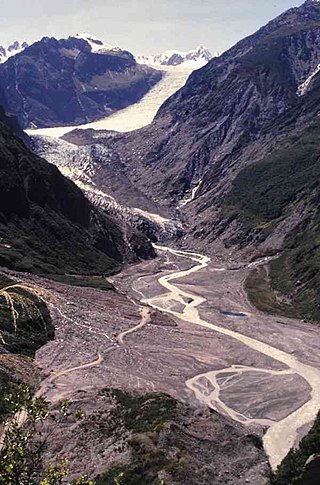
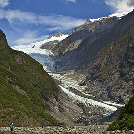
Fox Glacier is a 13-kilometre-long (8.1 mi) temperate maritime glacier located in Westland Tai Poutini National Park on the West Coast of New Zealand's South Island. Like nearby Franz Josef Glacier, Fox Glacier is one of the most accessible glaciers in the world, with a terminal face as low as 300 m above sea level, close to the village of Fox Glacier. It is a major tourist attraction and about 1000 people daily visit it during high tourist season.

<span class="mw-page-title-main">Tasman Glacier</span> Glacier in New Zealand

Tasman Glacier is the largest glacier in New Zealand, and one of several large glaciers which flow south and east towards the Mackenzie Basin from the Southern Alps in New Zealand's South Island.

<span class="mw-page-title-main">Westland Tai Poutini National Park</span> National park in New Zealand

Westland Tai Poutini National Park is a national park located on the western coast of New Zealand's South Island. Established in 1960 as Westland National Park to commemorate the centenary of the European settlement of Westland District, it covers 1,320 square kilometres of largely mountainous terrain and forest. The park borders the Aoraki / Mount Cook National Park along the Main Divide of the Southern Alps, and includes many of the West Coast's glaciers, most notably including the Fox / Te Moeka o Tuawe and Franz Josef / Kā Roimata o Hine Hukatere glaciers.

<span class="mw-page-title-main">Terminal moraine</span> Type of moraine that forms at the terminal of a glacier

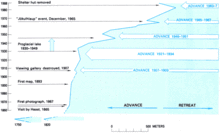
A terminal moraine, also called an end moraine, is a type of moraine that forms at the terminal (edge) of a glacier, marking its maximum advance. At this point, debris that has accumulated by plucking and abrasion, has been pushed by the front edge of the ice, is driven no further and instead is deposited in an unsorted pile of sediment. Because the glacier acts very much like a conveyor belt, the longer it stays in one place, the greater the amount of material that will be deposited. The moraine is left as the marking point of the terminal extent of the ice.

<span class="mw-page-title-main">Lake Matheson</span> Lake in New Zealand

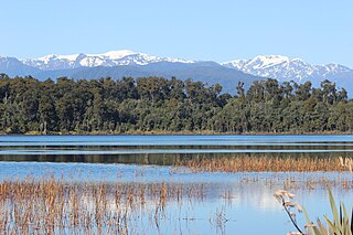
Lake Matheson is a small glacial lake in South Westland, New Zealand, near the township of Fox Glacier. It was a traditional food-gathering place for local Māori. An easy walking track circles the lake, which is famous for its reflected views of Aoraki / Mount Cook and Mount Tasman.

The Holocene glacial retreat is a geographical phenomenon that involved the global retreat of glaciers (deglaciation) that previously had advanced during the Last Glacial Maximum. Ice sheet retreat initiated ca. 19,000 years ago and accelerated after ca. 15,000 years ago. The Holocene, starting with abrupt warming 11,700 years ago, resulted in rapid melting of the remaining ice sheets of North America and Europe.

<span class="mw-page-title-main">Lake Mahinapua</span> Lake in New Zealand

Lake Mahinapua is a shallow lake on the West Coast of New Zealand's South Island. Once a lagoon at the mouth of the Hokitika River, it became a lake when the river shifted its course. Lake Māhinapua was the site of a significant battle between Ngāi Tahu and Ngāti Wairangi Māori, and is regarded by them as a sacred site where swimming and fishing are prohibited. In European times it was part of an inland waterway that carried timber and settlers between Hokitika and Ross until the building of the railway. Today it is protected as a scenic reserve for boating, camping, and hiking.

<span class="mw-page-title-main">Franz Josef / Waiau</span> Town in the West Coast Region of New Zealand

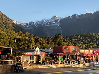
Franz Josef is a small town in the West Coast region of the South Island of New Zealand. Whataroa is 32 kilometres (20 mi) to the north-east, and the township of Fox Glacier is 23 kilometres (14 mi) to the south-west. The Waiho River runs from the Franz Josef Glacier to the south, through the town, and into the Tasman Sea to the north-west.

<span class="mw-page-title-main">Tasman Lake</span> Proglacial lake in Aoraki / Mount Cook National Park, South Island

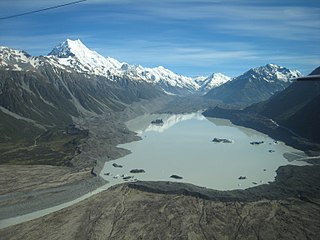
Tasman Lake is a proglacial lake formed by the recent retreat of the Tasman Glacier in New Zealand's South Island.

<span class="mw-page-title-main">Glaciers of New Zealand</span>

New Zealand contains many glaciers, mostly located near the Main Divide of the Southern Alps in the South Island. They are classed as mid-latitude mountain glaciers. There are eight small glaciers in the North Island on Mount Ruapehu.

<span class="mw-page-title-main">Fox Glacier (town)</span> Town in the West Coast Region of New Zealand

Fox Glacier, called Weheka until the 1940s, is a village on the West Coast of the South Island of New Zealand. The village is close to the eponymous Fox Glacier / Te Moeka o Tuawe.

<span class="mw-page-title-main">Waiho River</span> River in New Zealand

The Waiho River is a river of the West Coast region of New Zealand's South Island. It is fed by the meltwater of the Franz Josef Glacier and skirts the main township of Franz Josef to its south, where its river bed is crossed by SH 6 on a long single-lane bridge. Due to changes in rainfall and snow melt, the river's water flow varies greatly. In a severe rain storm on 26 March 2019, the bridge was destroyed after 400 millimetres (16 in) of rain had fallen. The bridge and one abutment was rebuilt, and the road link reopened after 18 days. The works cost NZ$6m.

<i>Sabatinca chrysargyra</i> Species of moth endemic to New Zealand

Sabatinca chrysargyra is a species of moth belonging to the family Micropterigidae. It was described by Edward Meyrick in 1886 and is endemic to New Zealand. It can be found from Franz Josef Glacier / Kā Roimata o Hine Hukatere south but only on the western side of the South Island. Adults are on the wing from the beginning of October until the middle of January. Larvae likely feed on foliose liverworts and have been found on species in the genus Plagiochila. The adult moths live in a range of habitats preferring sunny open spaces in forests or snow-tussock grasslands that can range in altitude from near sea level up to 1,230 m. This species is very similar in appearance to Sabatinca aemula and dissection of genitalia is required to distinguish between the two species.

<span class="mw-page-title-main">Westland temperate forests</span>

The Westland temperate forests, also known as the Westland temperate rainforests, is a temperate broadleaf and mixed forests ecoregion located along the central west coast of New Zealand’s South Island, also known as Te Waipounamu. These forests are found in the region of the Westland District, which spans approximately 11,880 square kilometers. It is bounded on the west by the Tasman Sea, and on the east by the Southern Alps. Much of this area is protected by the Westland Tai Poutini National Park.

<span class="mw-page-title-main">Waiau Glacier Coast Marine Reserve</span> Marine reserve in West Coast Region, New Zealand

Waiau Glacier Coast Marine Reserve is a marine reserve of the West Coast Region of New Zealand's South Island. It covers an area of 4,641 hectares or 46 km2, from 11 km south from Kohuamarua Bluff near Ōkārito, to Omoeroa Bluff, and about 4 km out to sea.

<span class="mw-page-title-main">Garden of Eden Ice Plateau</span> Glacier in the Southern Alps, New Zealand

The Garden of Eden Ice Plateau is a large ice field on the western side of New Zealand's Southern Alps / Kā Tiritiri o te Moana. At over 9 km (5.6 mi) long, the Garden of Eden is one of the largest ice fields in New Zealand, along with the equally-sized Garden of Allah Ice Field which sits just to the north. The ice field is one of many geographic features in the area between the main divide of the Southern Alps and the Adams Range which share biblical names, a convention first established by the earliest explorers to the area. The Garden's remote location and difficult conditions make research difficult, especially with restrictions on helicopter landings imposed through the designation of the area as Adams Wilderness Area in 2003. Despite this, the ice plateau has been a popular destination for tramping groups for over 80 years, with access routes from both coasts and easily reachable areas once on the plateau itself.

<span class="mw-page-title-main">Roberts Point Track</span> Tramping track in the West Coast, New Zealand

Roberts Point Track is an 11–12.3-kilometre tramping track in Franz Josef Glacier and Westland Tai Poutini National Park, New Zealand. It takes approximately 5 hours and 20 minutes to complete. Within the track are swing bridges, ice-carved rock, waterfalls, and sheer cliffs. After about an hour walk is Hende's Hut. It is classified by the Department of Conservation as an advanced track, requiring a "good level of fitness".

References

  1. "Glaciers in New Zealand". Te Ara: The Encyclopedia of New Zealand . Retrieved 16 January 2008.
  2. 1 2 "Franz Josef Glacier/Kā Roimata o Hine Hukatere". DOC . Retrieved 14 May 2008.
  3. 1 2 Waiho River at Franz Josef, South Westland Archived 2009-10-09 at the Portuguese Web Archive (from the New Zealand Ministry for the Environment website. Accessed 2008-05-23.)
  4. "Whenua". Te Rūnanga o Ngāi Tahu. Retrieved 14 June 2019.
  5. 1 2 Killick, David (30 August 2018). "The frozen tears of New Zealand's melting glaciers". Deutsche Welle. Retrieved 11 October 2020.
  6. "Glacier Name History". Glacier Country New Zealand. 29 January 2019. Archived from the original on 30 September 2020. Retrieved 19 October 2020.
  7. McSaveney, Eileen (1 March 2009). "Glaciers and glaciation". Te Ara: The Encyclopedia of New Zealand . Retrieved 12 February 2012.
  8. "Ngāi Tahu Claims Settlement Act 1998" . Retrieved 28 March 2016.
  9. 1 2 3 4 "Tasman, Franz Josef and Fox glaciers". Te Ara: The Encyclopedia of New Zealand . Retrieved 16 January 2008.
  10. 1 2 3 4 5 6 7 Wilson, Kerry-Jayne (2017). West Coast Walking: A naturalist's guide. Christchurch: Canterbury University Press. pp. 269–283. ISBN   978-1-927145-42-5.
  11. McSaveney, Eileen (24 September 2007). "Waiho moraine loop, Franz Josef". Te Ara – the Encyclopedia of New Zealand. Retrieved 28 September 2020.
  12. Johnston, Martin (19 November 2007). "Shrinking glaciers near crisis". New Zealand Herald .
  13. Fagan, Brian M. (2001). The Little Ice Age: How Climate Made History, 1300–1850. New York: Basic Books.
  14. Chinn, Trevor.J. (1989), "Glaciers of New Zealand", in Williams, R.S.; Ferrigno, J.G. (eds.), Satellite Image Atlas of Glaciers of the World – IRIAN JAYA, INDONESIA, and NEW ZEALAND, U.S. Geological Survey Professional Paper 1386-H, U.S. Geological Survey, p. 48, ISBN   0-607-71457-3
  15. Purdie, Heather; Anderson, Brian; Chinn, Trevor; Owens, Ian; MacKintosh, Andrew; Lawson, Wendy (2014). "Franz Josef and Fox Glaciers, New Zealand: Historic length records". Global and Planetary Change. 121: 41–52. Bibcode:2014GPC...121...41P. doi:10.1016/j.gloplacha.2014.06.008.
  16. Mitchell, Charlie (14 February 2017). "When the world's glaciers shrunk, New Zealand's grew bigger". Stuff . Retrieved 12 October 2020.
  17. Mackintosh, Andrew N.; Anderson, Brian M.; Lorrey, Andrew M.; Renwick, James A.; Frei, Prisco; Dean, Sam M. (14 February 2017). "Regional cooling caused recent New Zealand glacier advances in a period of global warming". Nature Communications. 8 (1): 14202. Bibcode:2017NatCo...814202M. doi: 10.1038/ncomms14202 . ISSN   2041-1723. PMC   5316876 . PMID   28195582.
  18. Mills, Laura (9 July 2012). "Franz Josef Glacier's 'rapid' retreat". The New Zealand Herald . Retrieved 13 July 2012.
  19. Ballance, Alison (23 February 2017). "The unusual case of the 'growing' glaciers". RNZ . Retrieved 11 October 2020.
  20. 1 2 3 Yarwood, Vaughan (May–June 2014). "The cold, hard truth". New Zealand Geographic. 127.
  21. Anderson, Brian; Lawson, Wendy; Owens, Ian (2008). "Response of Franz Josef Glacier Ka Roimata o Hine Hukatere to climate change". Global and Planetary Change. 63 (1). Elsevier: 23–30. Bibcode:2008GPC....63...23A. doi:10.1016/j.gloplacha.2008.04.003.
  22. 1 2 Grzelewski, Derek (July–September 1993). "Glaciers – ice on the move". New Zealand Geographic. 019.
  23. "Waiho Bridge reopens after being rebuilt in 18 days". RNZ . 13 April 2019. Retrieved 11 October 2020.
  24. Source Citation Moore, W. Robert. "New Zealand ' Down Under '." National Geographic Magazine, vol. LXIX, no. Two, Feb. 1936, pp. [165]+. National Geographic Archive 1888–1994, tinyurl.gale.com/tinyurl/EBhWJ4. Accessed 26 Mar. 2022. Gale Document Number: GALE|BAKTLL872081589
  25. 1 2 McMahon, Brendan; Sherman, Janna (27 September 2017). "Three options for future of Franz Josef". Otago Daily Times . Retrieved 11 October 2020.
  26. Petley, Dave (3 November 2017). "Managing the hazards in the town of Franz Josef, New Zealand". The Landslide Blog. Retrieved 11 October 2020.
  27. "Franz Josef Glacier/Kā Roimata o Hine Hukatere Walk".
  28. ABC News (13 June 2010). "Man falls to death on glacier". Australian Broadcasting Corporation. Retrieved 14 June 2010.
  29. "Obese tramper trapped in ice crevasse dies". The New Zealand Herald . APN News & Media. 17 September 2010. Retrieved 17 September 2010.
  30. "Alex Knob Track". Department of Conservation NZ. Retrieved 19 March 2015.
  31. "Franz Josef Glacier/Kā Roimata o Hine Hukatere". Department of Conservation NZ . Retrieved 19 March 2015.