Lake Kaniere

Last updated

Lake Kaniere
Lake Kaniere MRD 01.jpg
Lake Kaniere
Lake Kaniere
New Zealand relief map.jpg
Disc Plain red.svg
Lake Kaniere
NZ-SI plain map.png
Disc Plain red.svg
Lake Kaniere
Location Westland District, West Coast Region, South Island
Coordinates 42°50′S171°09′E / 42.833°S 171.150°E / -42.833; 171.150
Primary outflows Kaniere River
Basin  countriesNew Zealand
Max. length8 km (5.0 mi)
Max. width2 km (1.2 mi)
Surface area15 km2 (5.8 sq mi)
Max. depth195 m (640 ft)

Lake Kaniere is a glacial lake located on the West Coast of New Zealand's South Island, nearly 200 m deep and surrounded on three sides by mountains and mature rimu forest. It is regarded by many as the most beautiful of the West Coast lakes, [1] and is a popular tourist and leisure destination.

Contents

Geography

Lake Kaniere lies 19 kilometres (12 mi) southeast of Hokitika, between two mountain ranges. At about 15 km2 (5.8 sq mi), it is second only to Lake Brunner in size among the West Coast's lakes. It is oriented north-south, 8 km long and 2 km wide, and has a maximum depth of 195 m. [2] Mount Graham and Mount Upright / Te Taumata o Uekanuku are on the west coast of the lake, Tūhua on the east. The lake is included in the 7,000-hectare (17,000-acre) Lake Kaniere Scenic Reserve. [1]

The road from Hokitika meets the northern shore of the lake at "The Landing" and splits; Dorothy Falls Road runs up the entire eastern side of the lake past Hans Bay and Dorothy Falls to the Styx River, while the other fork goes a short way west to Sunny Bight. [2] A four-hour hiking trail continues down the west side of the lake before joining Dorothy Falls Road. [3] Most of the houses at Lake Kaniere today are holiday homes, and there is a DOC campground at Hans Bay. [4]

Geology

Lake Kaniere was created by the action of glaciers in the last ice age 14,000 years ago, like many West Coast lakes. It currently drains into the Tasman Sea at its northern end via the Kaniere River, but in the past its outlet was at the southern end, emptying into the Styx River. This exit was blocked by a landslide, diverting the water north. [1]

Lake Kaniere, West Coast, New Zealand 11.jpg
Lake Kaniere looking northwest from Mt Brown. The three main peaks on the west shore from left to right are Mt Upright / Te Taumata o Uekanuku (524 m), Mt Graham (829 m), and Conical Hill (764 m). The slopes of Tūhua (1125 m) can be seen to the right.

Fauna

The streams that feed into the lake are home to several species of native fish, including common bullies, longfin eels, banded kokopu and giant kokopu. [1] The lake has been stocked with fish in the past, and mostly contains brown trout and perch. [5] [6]

Many species of native birds can also be found on and around the lake, such as little shags, black shags, New Zealand scaup, paradise shelducks and pūkeko, and also, rarely, grey ducks. [1] There are several pairs of whio in the Styx River at the southern end of the lake. In the surrounding forest are yellow-crowned kākāriki, ruru, rifleman, brown creeper, and sometimes kea. [1]

Early Māori settlers found large numbers of kākāpō around the lake. [7]

Flora

Lake Kaniere Scenic Reserve is largely composed of mature rimu, and is considered one of the most ecologically-significant areas of lowland forest in the central West Coast. [1] The rimu forest composition varies: on the flat outwash terraces, it contains rātā (Metrosideros) and kaikawaka (Libocedrus bidwillii), while on the slopes there is more supplejack (Ripogonum scandens), kiekie (Freycinetia banksii), and miro (Prumnopitys ferruginea). In the swampier areas there are other tree species including manoao (Manoao colensoi), kaikawaka, and kahikatea (Dacrycarpus dacrydioides). [1]

Human history

1910 tourism postcard of the lake New Zealand. Department of Tourist and Health Resorts -Lake Kanieri New Zealand. New Zealand post card (carte postale), issued by the New Zealand Goverment Department of Tourist and Health Resorts (ca (21014317474).jpg
1910 tourism postcard of the lake
Painting by Alfred Walsh (1859-1916) Alfred Walsh - Lake Kanieri, Westland - 1979-48 - Auckland Art Gallery.jpg
Painting by Alfred Walsh (1859–1916)
Painting by Charles Blomfield (1848-1926) Charles Blomfield - Lake Kanieri - 1961-35 - Auckland Art Gallery.jpg
Painting by Charles Blomfield (1848–1926)

In pre-European times, Lake Kaniere was an important mahinga kai (food gathering place) for Māori, with longfin eels and weka being two of the most important food resources in and around the lake. [8]

In 1909 a small hydroelectric station was built on the Kaniere River, at a cost of £15,000, to power the pumping equipment at the Ross gold mine. [9] Water is taken near the weir at the northern end of the lake and travels 9 km through a series of tunnels and flumes to a twin power plant capable of generating 520 kW; the water race was originally used for gold sluicing in the Kaniere area. The most prominent of the wooden flumes, Johnson's Flume, collapsed in 1973 and was replaced by earthworks. The Kaniere Forks power station later supplied the gold dredge at Rimu, and after 1931 exclusively generated power for Hokitika, today supplying 3.75 GWh annually to the town. [9] [10] A 3½ hour walkway follows the water race, part of the West Coast Wilderness Trail. [11]

Lake Kaniere is a popular location for leisure activities such as camping, picknicking, jetboating, jetskiing, and water skiing. [5] It is occasionally used by naturists for nude swimming; [12] New Zealand has no official nude beaches, as public nudity is legal on any beach where it is "known to occur". [13] It is also the main water supply for Hokitika. [14]

Related Research Articles

<span class="mw-page-title-main">West Coast Region</span> Region of New Zealand

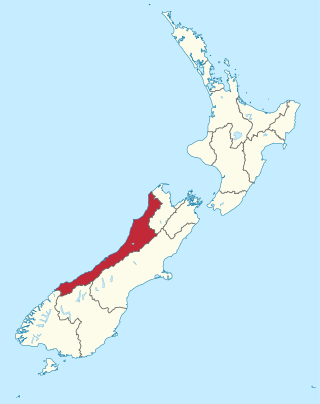
The West Coast is a region of New Zealand on the west coast of the South Island that is administered by the West Coast Regional Council, and is known co-officially as Te Tai Poutini. It comprises the territorial authorities of Buller District, Grey District and Westland District. The principal towns are Westport, Greymouth and Hokitika. The region, one of the more remote areas of the country, is also the most sparsely populated. With a population of just 32,000 people, Te Tai Poutini is the least populous region in New Zealand, and it is the only region where the population is declining.

<span class="mw-page-title-main">Hokitika</span> Town in West Coast, New Zealand

Hokitika is a town in the West Coast region of New Zealand's South Island, 40 kilometres (25 mi) south of Greymouth, and close to the mouth of the Hokitika River. It is the seat and largest town in the Westland District. The town's estimated population is 2,860 as of June 2022.

<span class="mw-page-title-main">Lake Brunner</span> Lake in the South Island of New Zealand

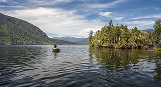
Lake Brunner is the largest lake in the West Coast Region of New Zealand, located 31 km (19 mi) southeast of Greymouth. The main settlement, Moana, is on its northern shore. It is an important settlement and waystation for local Māori. The first Europeans in the area were loggers, and sawmills were an important early industry. Being several kilometres inland from the coast road, it is less frequently visited by tourists than many of the West Coast's scenic highlights, but it is becoming increasingly popular, in part due to its reputation for fishing.

<span class="mw-page-title-main">Ōkārito Lagoon</span> Lagoon in New Zealand

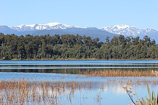
Ōkārito Lagoon is a coastal lagoon on the West Coast of New Zealand's South Island. It is located 130 kilometres (81 mi) south of Hokitika, and covers an area of about 3,240 hectares (12.5 sq mi), making it the largest unmodified coastal wetland in New Zealand. It preserves a sequence of vegetation types from mature rimu forest through mānuka scrub to brackish water that has been lost in much of the rest of the West Coast. The settlement of Ōkārito is at the southern end of the lagoon.

<span class="mw-page-title-main">Westland District</span> Territorial authority district in West Coast, New Zealand

Westland District is a territorial authority district on the West Coast of New Zealand's South Island. It is administered by the Westland District Council. The district's population is 8,820.

<span class="mw-page-title-main">Lake Matheson</span> Lake in New Zealand

Lake Matheson is a small glacial lake in South Westland, New Zealand, near the township of Fox Glacier. It was a traditional food-gathering place for local Māori. An easy walking track circles the lake, which is famous for its reflected views of Aoraki / Mount Cook and Mount Tasman.

<span class="mw-page-title-main">Lake Mahinapua</span> Lake in New Zealand

Lake Mahinapua is a shallow lake on the West Coast of New Zealand's South Island. Once a lagoon at the mouth of the Hokitika River, it became a lake when the river shifted its course. Lake Māhinapua was the site of a significant battle between Ngāi Tahu and Ngāti Wairangi Māori, and is regarded by them as a sacred site where swimming and fishing are prohibited. In European times it was part of an inland waterway that carried timber and settlers between Hokitika and Ross until the building of the railway. Today it is protected as a scenic reserve for boating, camping, and hiking.

<span class="mw-page-title-main">Mōkihinui River</span> River in New Zealand

The Mōkihinui River is a river located on the West Coast of New Zealand's South Island, about 40 kilometres north of Westport. Meridian Energy had proposed the Mokihinui Hydro project on the river in 2007 but it was cancelled in May 2012. In 2019, it was announced that large parts of the river catchment, including 15 km (9.3 mi) of river bed, would be added to Kahurangi National Park.

Kaniere is a small town in the Westland District of the West Coast region of New Zealand's South Island. Hokitika lies to the north-west, and the Hokitika River flows past to the south-west.

<span class="mw-page-title-main">Fox Glacier (town)</span> Town in the West Coast Region of New Zealand

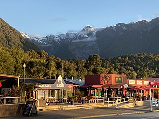
Fox Glacier, called Weheka until the 1940s, is a village on the West Coast of the South Island of New Zealand. The village is close to the eponymous Fox Glacier / Te Moeka o Tuawe.

<span class="mw-page-title-main">West Coast Treetop Walk</span>

The West Coast Treetop Walk is a canopy walkway through mature rimu forest near Hokitika on the West Coast of the South Island of New Zealand. The tourist attraction was built by Australian eco-tourism company 'Canopy01' in 2012 and comprises a 450 metres (1,480 ft) long elevated steel walkway, viewing tower, and cantilever.

<span class="mw-page-title-main">West Coast Wilderness Trail</span>

The West Coast Wilderness Trail has been funded as one of the projects of the New Zealand Cycle Trail. Once complete, the 139 kilometres (86 mi) track will connect Greymouth in the north with Ross in the south.

<span class="mw-page-title-main">Hokitika & Kanieri Tramway</span>

The Hokitika & Kanieri Tramway was an 3.5 kilometres (2 mi) long, privately owned bush tramway with a gauge of 3 ft 6 in between Hokitika and Kaniere in the Westland District on the West Coast of the South Island, New Zealand, which operated from 1866 to 1914 as a horse-drawn tram and from the 1920s to 1950s as a logging railway.

<span class="mw-page-title-main">Hokitika Gorge</span>

Hokitika Gorge and the surrounding Hokitika Gorge Scenic Reserve are a major tourist destination some 33 kilometres (21 mi) or 40 minutes drive inland from Hokitika, New Zealand. Since August 2020, a second suspension bridge over the Hokitika River at the gorge provides the opportunity for a round track.

<span class="mw-page-title-main">Ebenezer Teichelmann</span> New Zealand doctor, photographer, explorer

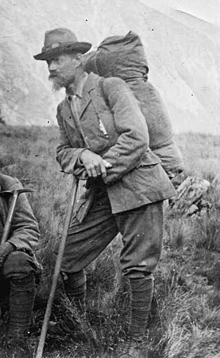
Ebenezer Teichelmann, known as 'the little Doctor' to his friends, was an Australian-born surgeon, mountaineer, explorer, conservationist and photographer in New Zealand. He was a survivor of the sinking of the SS Marquette in 1915. He achieved 26 first ascents of mountains and seven first ascents, or crossings, of passes, cols, or saddles, and is credited with reviving climbing in New Zealand when the sport was almost dead. A keen photographer, he used a full-plate glass camera, which was hauled up many mountains. His photographs were used in books and advertisements, and helped to achieve conservation status for West Coast reserves.

<span class="mw-page-title-main">Wairarapa Moana Wetlands</span> A protected regional park and a wetland of international significance

The Wairarapa Moana Wetlands are a major wetland, located in the South Wairarapa District in the Wellington Region at the southern end of New Zealand's North Island.

<span class="mw-page-title-main">Lake Wahapo</span> Lake in New Zealand

Lake Wahapo is a small glacial lake in South Westland, New Zealand, within the Westland Tai Poutini National Park and near the township of Whataroa. It was a traditional mahinga kai for local Māori. State Highway 6 skirts the lake's southern shore. The lake discharges to the Ōkārito River via a small hydroelectric power station commissioned in 1960. The ecology of the lake has altered considerably since 1967, when the Waitangitāhuna River changed course to flow into the lake.

<span class="mw-page-title-main">Te Matuku Marine Reserve</span>

Te Matuku Marine Reserve is a marine reserve administered by the New Zealand Department of Conservation. It includes Te Matuku Bay, one of the largest and least disturbed estuaries on Waiheke Island, as well as a surrounding area of sea. It covers an area of 690 ha and was established in 2003.

<span class="mw-page-title-main">Barrytown Flats</span> Coastal plain in New Zealand

The Barrytown Flats are a 17 km (11 mi) coastal plain north of Greymouth on the West Coast of New Zealand's South Island. A series of postglacial shorelines and dunes backed by a former sea cliff, they was originally covered with wetland and lowland forest, including numerous nīkau palms. The sands were extensively sluiced and dredged for gold from the 1860s, centred on the small settlement of Barrytown. The drier areas of the flats have been converted into pasture, but significant areas of forest remain, including Nikau Scenic Reserve. The flats are bordered by Paparoa National Park and the only breeding site of the Westland petrel. There are significant deposits of ilmenite in the Barrytown sands, and there have been several mining proposals, but the possible environmental consequences have been contentious.

References

  1. 1 2 3 4 5 6 7 8 Wilson, Kerry-Jayne (2013). West Coast Walking. A Naturalist's Guide. Christchurch, New Zealand: Canterbury University Press. pp. 236–238. ISBN   978-1-927145-42-5.
  2. 1 2 "Lake Kaniere Scenic Reserve". Department of Conservation Te Papa Atawhai. Retrieved 1 October 2020.
  3. "Lake Kaniere Walkway". www.doc.govt.nz. Retrieved 1 October 2020.
  4. Winter, Matt (22 March 2018). "Idyllic Lake Kaniere". NZ Today Magazine. Retrieved 1 October 2020.
  5. 1 2 Pope, Diana; Pope, Jeremy (1978). Mobil New Zealand travel guide : South Island and Stewart Island (3rd rev. ed.). Wellington [N.Z.]: Reed. ISBN   0-589-00998-2.
  6. "Lake Kaniere". nzfishing.com. Retrieved 1 October 2020.
  7. "Kaniere – frigate". Torpedo Bay Navy Museum. Retrieved 2 October 2020.
  8. "Ngāi Tahu Claims Settlement Act 1998: Schedule 31 – Statutory acknowledgement for Lake Kaniere" . Retrieved 2 October 2020.
  9. 1 2 Riley, Cheryl (2009). Power from the People. Greymouth: West Coast Electric Power Trust. pp. 66–67. ISBN   978-0-473-15728-9.
  10. "Kaniere Forks Power Station - McKays Creek - Kaniere Reservoir - Trustpower". www.trustpower.co.nz. Archived from the original on 19 August 2021. Retrieved 1 October 2020.
  11. "Lake Kaniere | Hokitika, New Zealand Attractions". Lonely Planet. Retrieved 1 October 2020.
  12. "Naturist Beaches - Rest of South". FreeBeaches NZ. Retrieved 1 April 2021.
  13. Ceramalus v Police,AP No 76/91( High Court of New Zealand 5 July 1991).
  14. "Lake Kaniere". Westland District Council. 20 August 2014. Archived from the original on 25 June 2021. Retrieved 1 October 2020.