
The Pastaza River also known as the Patate, flowing in Ecuador and Peru is a large tributary to the Marañón River in the northwestern Amazon Basin of South America.
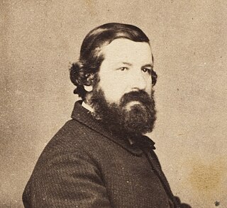
Sir Johann Franz Julius von Haast was a German-born New Zealand explorer, geologist, and founder of the Canterbury Museum in Christchurch.
The National Topographic System or NTS is the system used by Natural Resources Canada for providing general purpose topographic maps of the country. NTS maps are available in a variety of scales, the standard being 1:50,000 and 1:250,000 scales. The maps provide details on landforms and terrain, lakes and rivers, forested areas, administrative zones, populated areas, roads and railways, as well as other human-made features. These maps are currently used by all levels of government and industry for forest fire and flood control, depiction of crop areas, right-of-way, real estate planning, development of natural resources and highway planning. To add context, land area outside Canada is depicted on the 1:250,000 maps, but not on the 1:50,000 maps.

Haast is a small town in the Westland District territorial authority on the West Coast of New Zealand's South Island. The township is beside the Haast River, 3 kilometres (2 mi) south of Haast Junction, on State Highway 6. The Haast region is in Te Wahipounamu – The South West New Zealand World Heritage, a UNESCO World Heritage Site designated in 1990.
The Aan River is a short river in the South Island of New Zealand.
Haast Pass / Tioripatea is a mountain pass in the Southern Alps of the South Island of New Zealand. Māori used the pass in pre-European times.

Mount Aspiring / Tititea is New Zealand's 23rd-highest mountain. The peak's altitude of 3,033 metres (9,951 ft) makes it the country's highest outside the Aoraki / Mount Cook region.

The Landsborough River is located in New Zealand's South Island. A major tributary of the Haast River, it flows southwest, parallel with the Southern Alps, for 50 kilometres from its source five kilometres north of Mount Hopkins to meet the Haast 12 kilometres below the Haast Pass.

A national mapping agency (NMA) is an organisation, usually publicly owned, that produces topographic maps and geographic information of a country. Some national mapping agencies also deal with cadastral matters.

Ōhinetamatea River / Saltwater Creek is a river in the Westland District of New Zealand.

The Hope River is in the Tasman District of the South Island of New Zealand. It is the northernmost of three Hope Rivers in the South Island.
Mount Franklin is a peak in the Nelson Lakes National Park in the Tasman Region of New Zealand. It is the northernmost – and highest – of New Zealand's four Mounts Franklin, located 15 kilometres (9.3 mi) south of Lake Rotoroa. It is the highest peak in the Tasman Region, just two metres higher than the nearby Mount Travers.
The Tasman Region's Clarke River is one of three rivers by that name in the South Island of New Zealand. It rises in the Kahurangi National Park from the eastern flanks of Mount Gomorrah flowing southeast then northeast before joining the Baton River 10 kilometres (6 mi) northwest of the township of Tapawera.
The Clarke River is a river in the Grey District, one of three Clarke rivers in the South island of New Zealand. It flows northwest for 12 kilometres before joining with the upper Grey River close to the boundary of Victoria Forest Park.
The Cass River is an alpine river in the Canterbury region of the South Island of New Zealand. It rises in the Hall Range immediately below Rankin Pass, and also receives water from the nearby Huxley Glacier. After dropping 600 metres (2,000 ft) very rapidly the river flows south with braided channels along a flat-bottomed valley for 25 kilometres (16 mi). The Leibig Range and Gamack Range are to the west, and the Haszard Range to the east. The river flows into the west side of Lake Tekapo where it has built up a gravel delta.
The Robinson River is a river in the West Coast Region of the South Island of New Zealand. It is a tributary of the Upper Grey River and much of the river lies within the Lake Sumner Conservation Park. Rising on the slopes of Mount Boscawen on the main divide about 12 kilometres (7.5 mi) south of the Lewis Pass, the river runs west-southwest along a straight, narrow valley before turning northwest to reach the Upper Grey.

The Ashburton River / Hakatere is a river in the Canterbury region of New Zealand, flowing across Mid Canterbury from the Southern Alps to the Pacific Ocean. The official name of the river was amended to become a dual name by the Ngāi Tahu Claims Settlement Act 1998. It has been identified as an Important Bird Area by BirdLife International because it supports breeding colonies of the endangered black-billed gull.
Pleasant Flat is an alluvial floodplain of the Haast River in the Haast Pass on New Zealand's South Island. A former stopping place for travellers crossing the pass before the building of the highway, it now has a campsite and picnic shelter. It has a notable view of Mount Hooker to the northeast.

The historic Haast to Paringa Cattle Track is a trail through South Westland, New Zealand, constructed in 1875 to allow farmers in the Landsborough and Cascade Valley area to drive their cattle on an annual two-week journey to the sale yards in Whataroa. It was constructed as an inland loop to bypass the precipitous cliffs at Knights Point. For 90 years it was the only land access to the settlements of Haast and Jackson Bay, but the last mob of cattle was driven in 1961, and the construction of a highway connecting Paringa to Haast Pass in 1965 made it redundant. After falling into disuse, the cattle track was converted into a 33-kilometre (21 mi), three-day tramping track, opening in 1981. The track and its three huts are maintained by the New Zealand Department of Conservation.

Thunder Creek Falls is a waterfall in Mount Aspiring National Park, Westland District, New Zealand. It is located in the Haast River valley, around 52 kilometres (32 mi) inland from Haast, near the Gates of Haast bridge on State Highway 6. The falls are about 28 metres (92 ft) high and the base is at an elevation of around 120 metres (390 ft) where it flows into the Haast River.


